

MLS Number : 5227200
Sold $46,900 - Hunting & Recreation
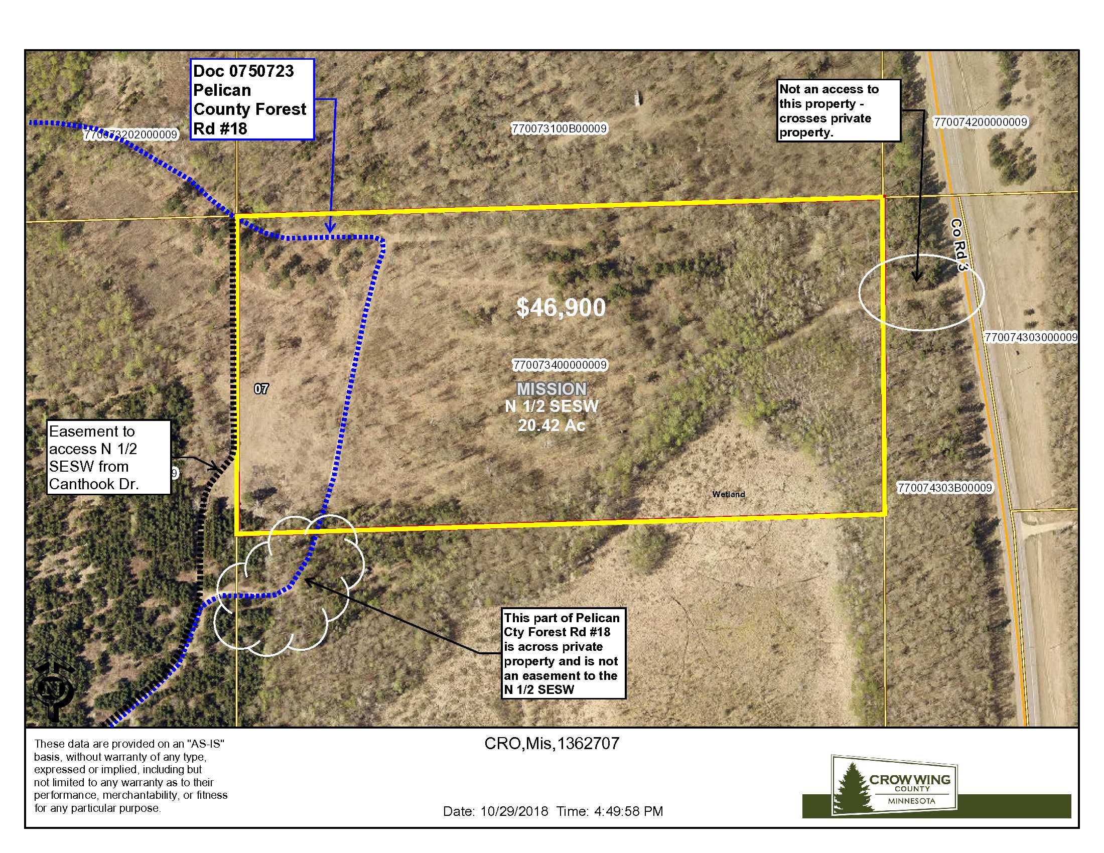
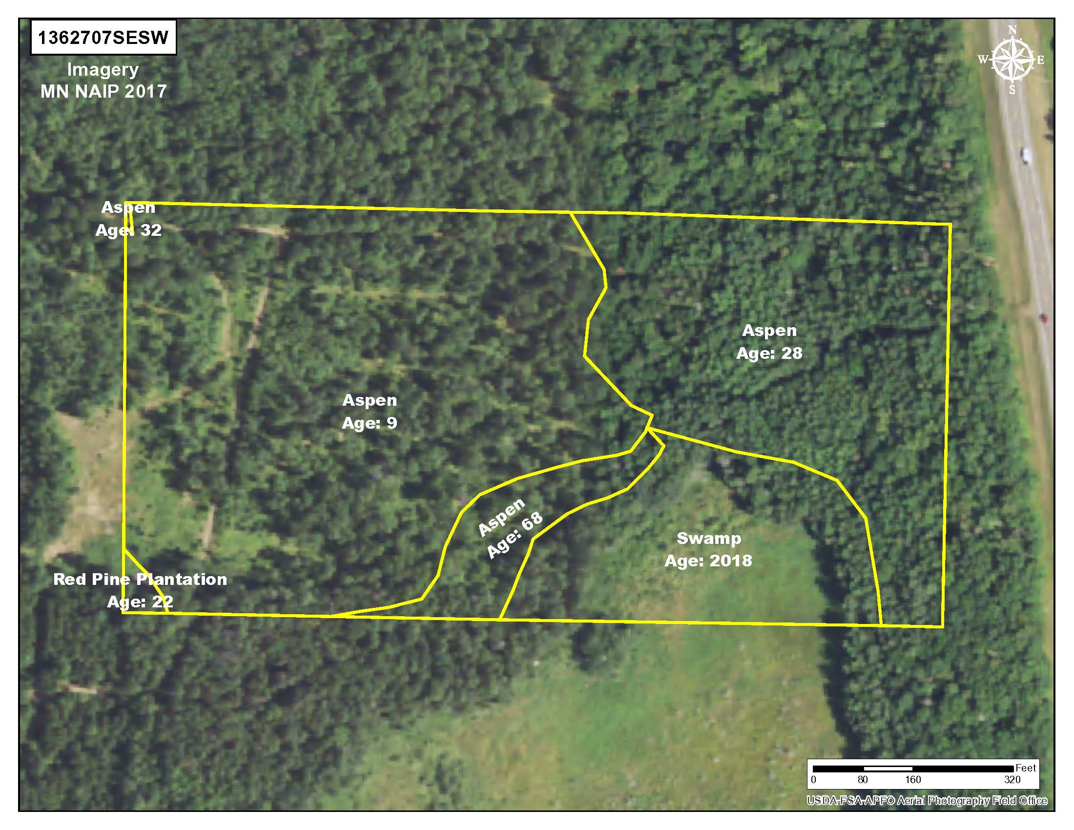
This 20 acre parcel is located in the center of the Brainerd Lakes area. Near the northeast shore of Pelican Lake off Canthook Drive on the Pelican Cty Forest Road #18. The tract is forested with 9 to 68-year-old aspen and overlooks a small wetland. Ideal for recreation or possible building site. The topography is level to sloping toward the wetland in the southeast corner of the property. This parcel has been carefully managed by PotlatchDeltic for decades. Near so many great amenities, yet feels very private. Just minutes from Breezy Point, Merrifield and Crosslake, the Whitefish Chain, Pelican and Horeseshoe Lakes. This parcel is in the Crosby-Ironton School District and just minutes away from the new Crosslake Community School. There are shared easements that affect the property. See Supplements for details.
Main Property Info
770073400000009
5227200
Sold
$46,900
$46,900
20.46
RR 2.5
Merrifield
Mission Twp
MN
56465
Crow Wing
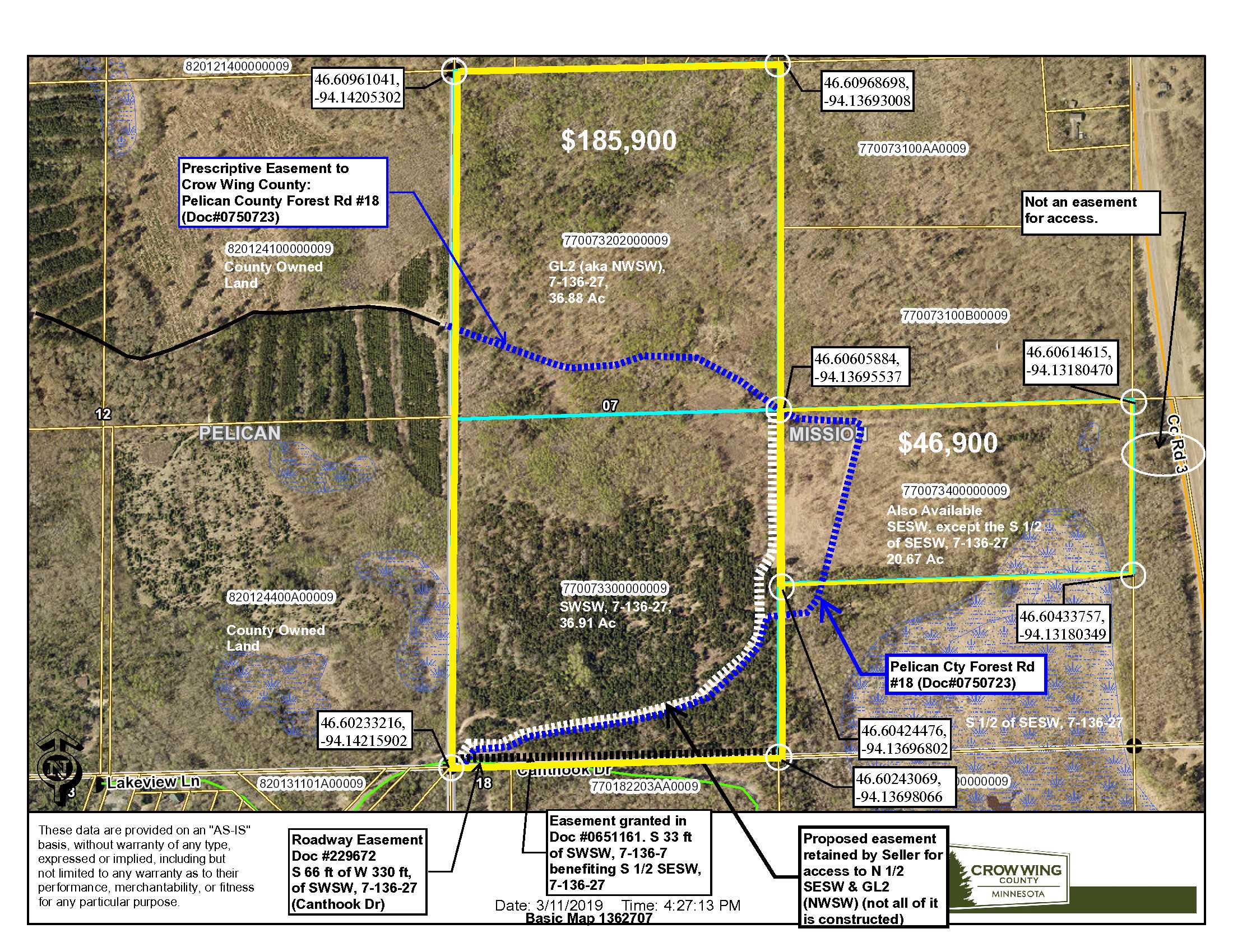
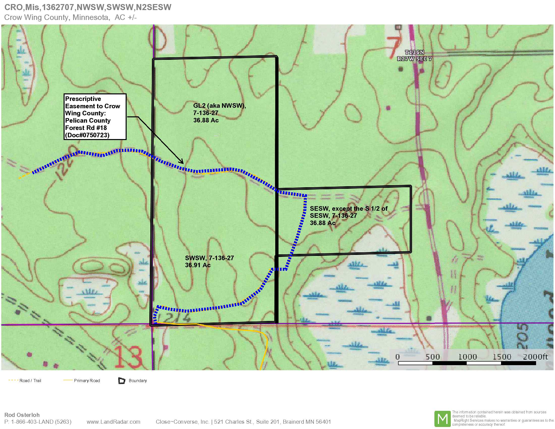
See EXHIBIT A. SESW, except the S half thereof, 7-136-27, Crow Wing County, Minnesota. Together with easement as shown and described in attached Easement Sketch and Easement Description. Subject to Pelican County Forest Road #18 per Doc #0750723 (Supplement B) and any other easements, restrictions, or reservations of record. Note: Easements granted and/or reserved will include terms governing shared use.
Property Location
From Brainerd MN at the intersection of Hwy 210 and Co Rd 3, North on Co Rd #3 for 17.3 miles to North Pelican Ln (on the west side of Co Rd 3); West on N Pelican Ln for .3 mile to Canthook Ln; North on Canthook Ln for .5 mile to trail on the North side (Pelican County Forest Rd #18) – near the SW’ly corner of the SWSW; Northerly and easterly on Pelican County Forest Rd #18 approximately .28 miles to the west line of the S ½ SESW (NOTE: Pelican County Forest Rd #18 continues on through this private property, but Seller does not have an easement to use Forest Rd #18 across the private property); See EXHIBIT A for the easement description and sketch of where this parcel can be accessed along the west line of the N ½ SESW (as of 3/13/19, this portion of the easement hasn’t been constructed).
Access to this tract is via the existing forest trail, aka Pelican County Forest Rd #18 (provides access to the County-owned land west of this tract). Just before PCFR#18 turns right into the S ½ SESW, the retained easement to this property continues north and angles to the west side of this parcel. Refer to maps and EXHIBIT A for more information.
Coordinates to approximate corners/points based on county mapping: NW: 46.60605884, -94.13695537 NE: 46.60614615, -94.13180470 SE: 46.60433757, -94.13180349 SW: 46.60424476, -94.13696802
N ½ SESW Pelican Cty Forest Rd #18, Mission Twp, Merrifield
Crosby-Ironton - 182
Property Details
0
18
1320 x 660 x 1320 x 660
Utilities
Electric and telephone
None
Crow Wing Power (1-800-648-9401)
Waterfront
None
None
None`
N/A
Taxes & Fees
No
$0
0
$240
0
$240
No
None
2018
Other Details
07
136
27
90
10
Additional Comments
This tract has been managed by PotlatchDeltic as commercial timberland. The tract is aspen, ranging from 9 to 68-years of age. If timber value is important to your use, consult with a forester.
Zone 242, which lies west of County Road 3. Adjoining 120 acres of County-owned land, this tract plays bigger than 73 acres. Well placed food plots could attract substantial wildlife. For information on this permit area, see: http://files.dnr.state.mn.us/recreation/hunting/deer/dpa/DPA242.pdf. NOTE: CWD was discovered in Mission Twp, but some distance from this property. Contact the MN DNR for details if this is a concern or refer to this link on the DNR’s CWD website https://www.dnr.state.mn.us/cwd/index.html.
This property is subject to Pelican County Forest Road #18 and together with an easement for ingress, egress and utility purposes. Acreage, dimensions, and taxes estimated based on county data and mapping or seller data; county disclaimers included by reference; subject to split approval if necessary. Not surveyed. Photos/maps and GPS coordinates for convenience only and not guaranteed; physically inspect prior to purchase. Any deer stands on the land are not property of seller and are not included in sale. Shared easements affect the property. See Map Easement Supplements for details.


