

MLS Number : 5227459
Sold $185,900 - Hunting & Recreation
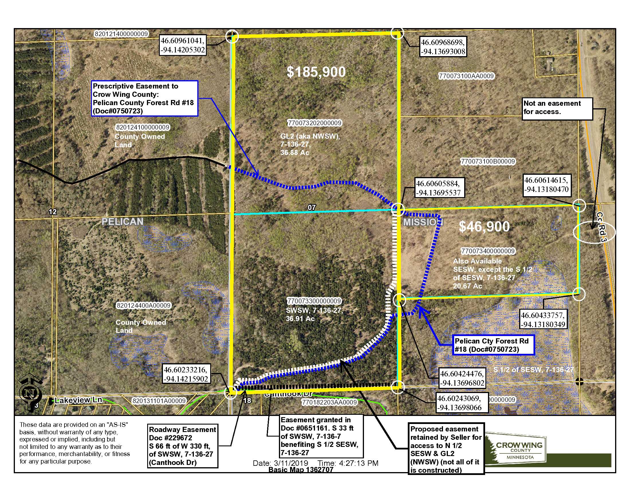
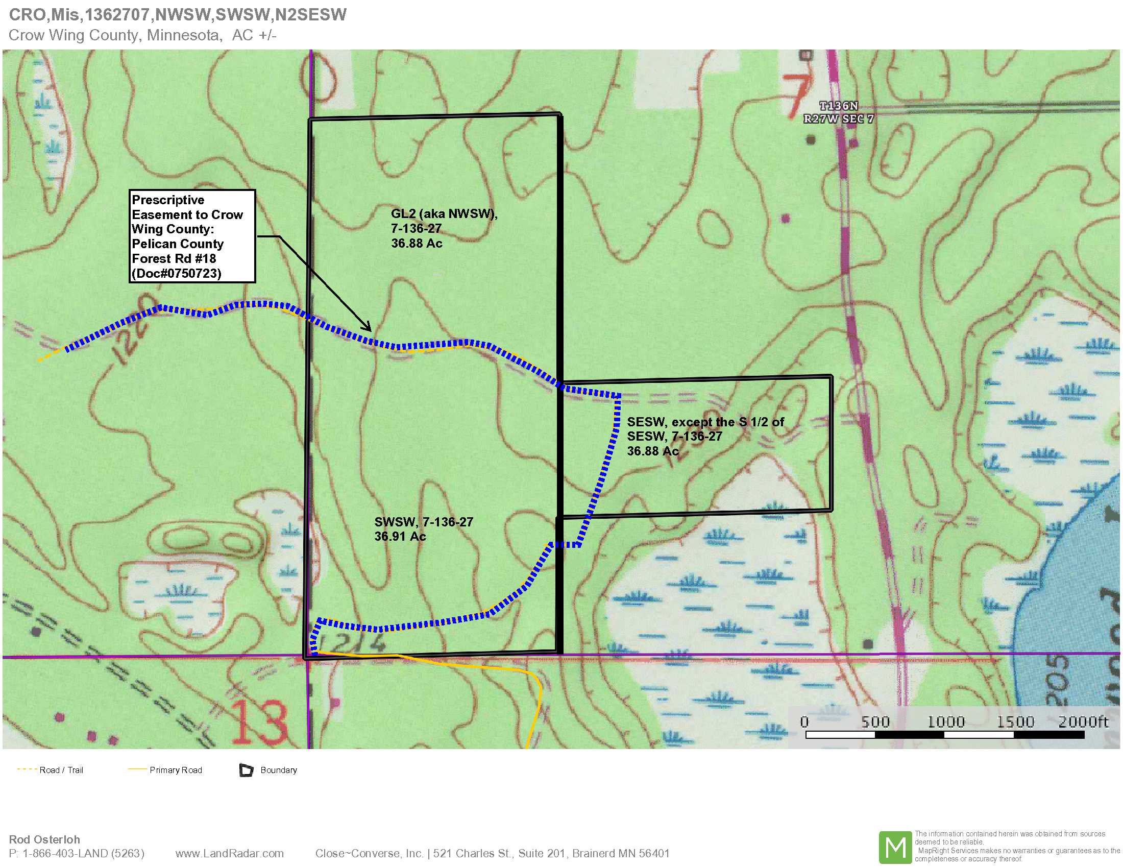
It’s rare to find 73 acres close to Pelican Lake north of Brainerd. This parcel is located just off the northeast shore of Pelican Lake on Canthook Drive and is heavily forested. It’s an upland tract and is ideal for hunting, recreation or a possible building site. A combination of red pine and aspen provides good wildlife habitat with level to rolling terrain. This tract has been carefully managed by PotlatchDeltic for decades and could yield future timber income if desired. This tract is in a great location in the Brainerd Lakes area. Close to Crosslake, Breezy Point and Merrifield. There are plentiful nearby lakes, many with public accesses, including Pelican, the Ossawinnamakee Chain and the Whitefish Chain. This property is within the Crosby-Ironton School District and just a short distance from the brand new Crosslake Community School. Shared easements affect this tract.
Main Property Info
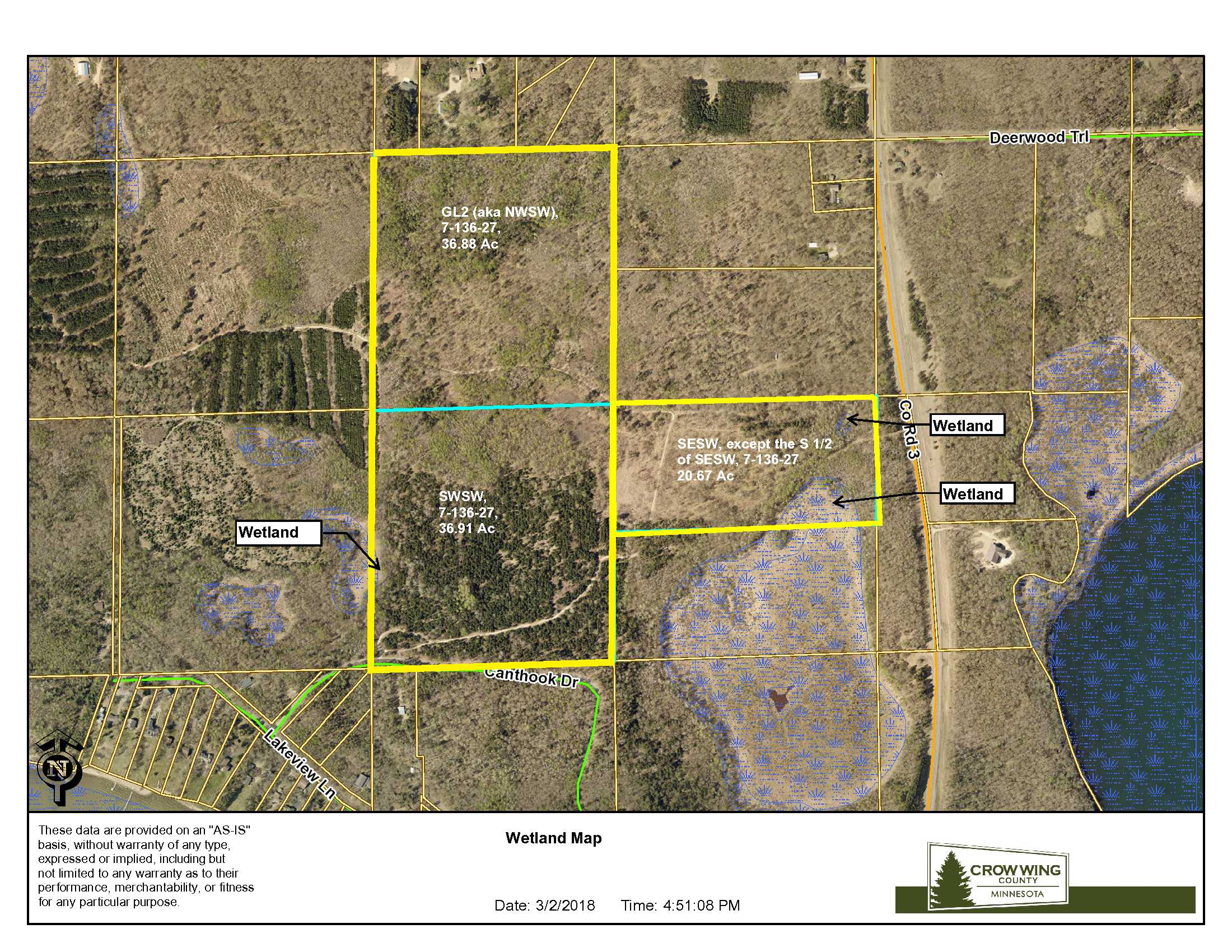
GL2(NWSW) #770073202000009 and SWSW #770073300000009
5227459
Sold
$185,900
$185,900
73.97
RR 2.5
Merrifield
Mission Twp
MN
56465
Crow Wing
See attached EXHIBIT A GL2 (aka NWSW) and SWSW, 7-136-27, Crow Wing County, Minnesota. Together with & subject to an easement retained by Seller for ingress, egress and utility purposes as described on Exhibit A, attached, benefiting the N ½ SESW & GL2(NWSW). Subject to Pelican County Forest Road #18 & easements in Documents #0750723, #0651161 and #229672. Subject to easements, restrictions and reservations of record, if any. Note: Easement(s) granted and/or reserved will include terms governing shared use of the easement(s).
Property Location
From Brainerd MN at the intersection of Hwy 210 and Co Rd 3, North on Co Rd #3 for 17.3 miles to N Pelican Ln on the west side of Co Rd 3; West on N Pelican Ln for .3 mile to Canthook Ln; North on Canthook Ln for .5 mile to trail on the North side (Pelican County Forest Rd #18) – near the SW’ly corner of the subject property.
The Access to the interior of the property is via the forest trail, aka Pelican County Forest Rd #18, which provides access to the County-owned land west of this tract. Shared easements affect this tract.
Coordinates to approximate corners/points based on county mapping: NW: 46.60961041, -94.14205302 NE: 46.60968698, -94.13693008 SE: 46.60243069, -94.13698066 SW: 46.60233216, -94.14215902
GL2(NWSW)&SWSW Canthook Dr, Mission Twp, Merrifield
Crosby-Ironton - 182
Property Details
0
73
1235 x 2640 x 1249 x 2647
Utilities
Electric and telephone
None
Crow Wing Power (1-800-648-9401)
Waterfront
None
None
None
N/A
Taxes & Fees
No
$0
0
$978
0
$978
No
None
2018
Other Details
136
27
07
99
1
Additional Comments
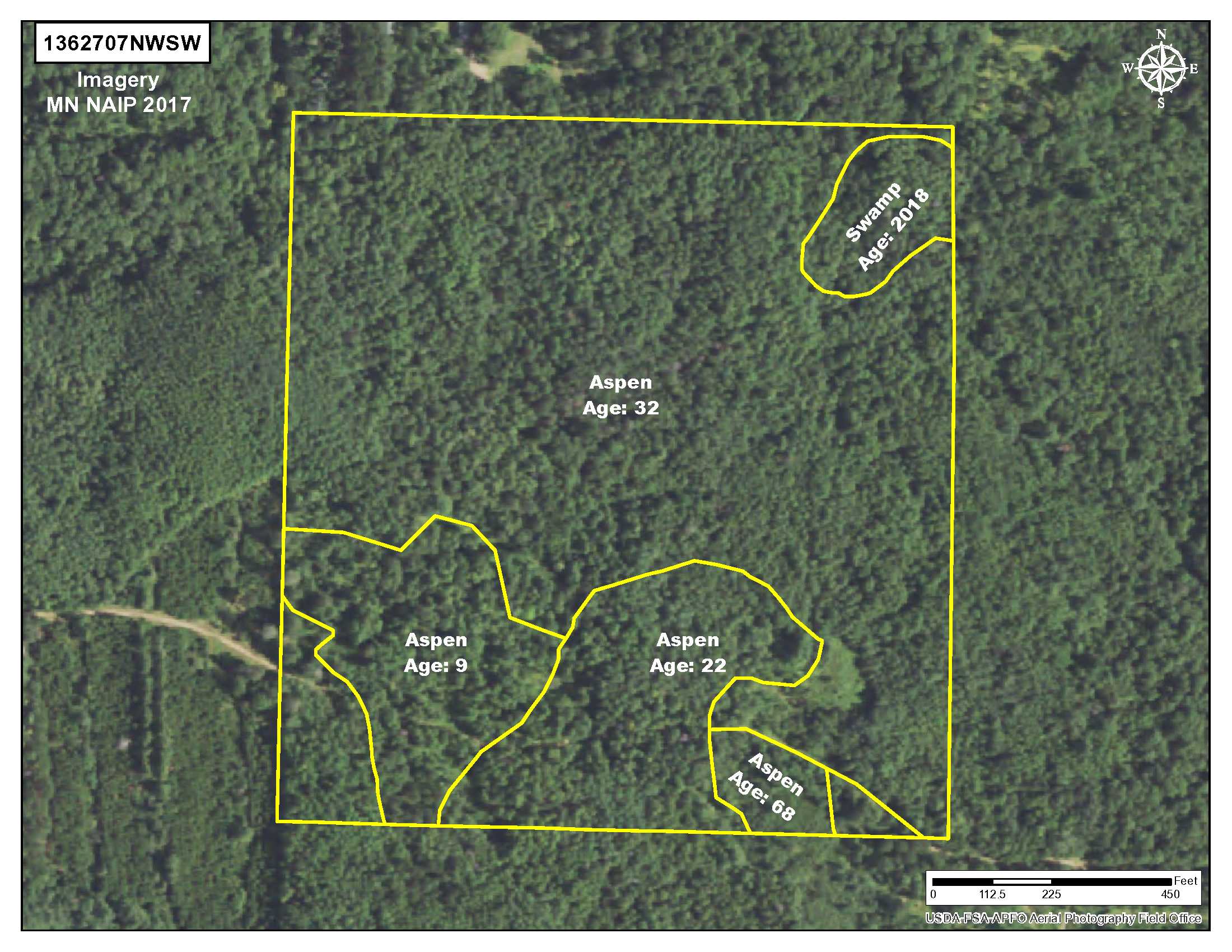
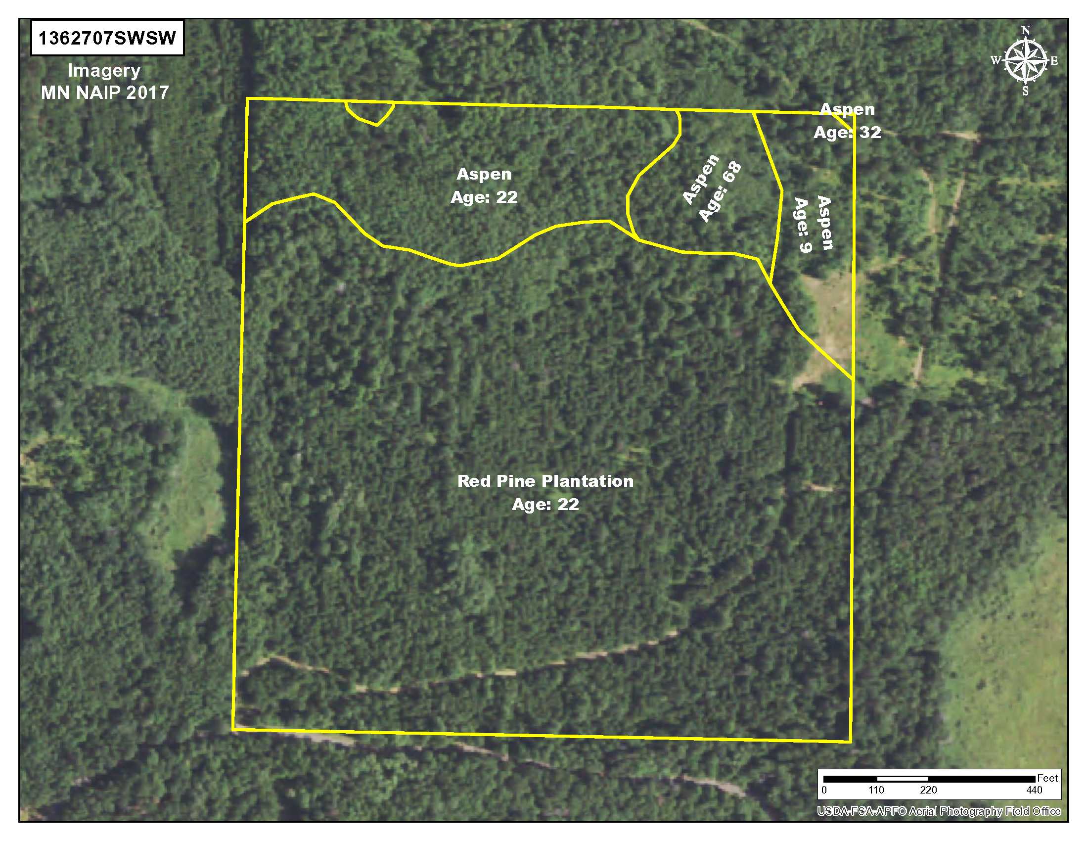
This tract has been managed by PotlatchDeltic as commercial timberland. The larger portion of the tract is aspen, ranging from 9 to 32 years of age, and the southerly portion of the property is red pine plantation, 22 years old. If desired, future harvests or thinning of the timber could yield income to the owner. If timber value is important to your use, consult with a forester.
Zone 242, which lies west of County Road 3. Adjoining 120 acres of County-owned land, this tract plays bigger than 73 acres. Well placed food plots could attract substantial wildlife. For information on this permit area, see: http://files.dnr.state.mn.us/recreation/hunting/deer/dpa/DPA242.pdf. NOTE: CWD was discovered in Mission Twp, but some distance from this property. Contact the MN DNR for details if this is a concern or refer to this link on the DNR’s CWD website https://www.dnr.state.mn.us/cwd/index.html.
This property is subject to Pelican County Forest Road #18 and easements along the southerly boundary and an easement to be retained by Seller to provide access to Seller’s property – the N ½ SESW (aka SESW except the South ½ of the SESW), 7-136-27. Acreage, dimensions, and taxes estimated based on county data and mapping or seller data; county disclaimers included by reference; subject to split approval if necessary. Not surveyed. Photos/maps and GPS coordinates for convenience only and not guaranteed; physically inspect prior to purchase. Any deer stands on the land are not property of seller and are not included in sale. Shared easements affect the property. See Map Easement Supplements for details. Use seller-approved PA and addendum; closing dates the 3rd Wednesday each month.


