

MLS Number : 4612359
Sold $209,000 - Hunting & Recreation, Waterfront Properties
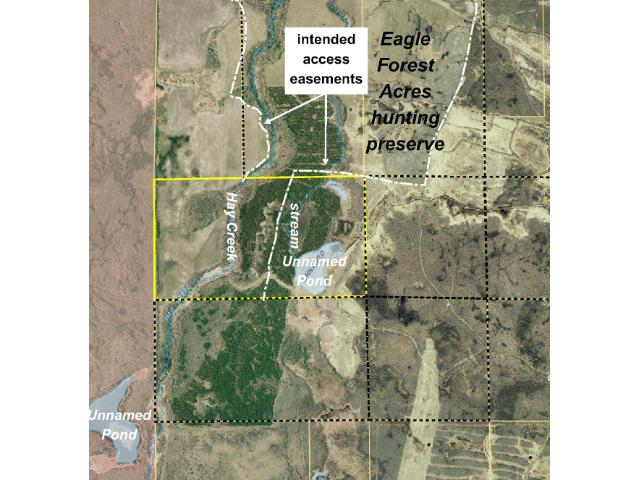
Approx 281 acres on Hay Creek adjacent to Eagle Forest Acres hunting preserve & just off the shores of Red Lake. Mostly wooded w/ preserved creek (+/- 4,300 ft), stream (+/- 2,200 ft), & pond (+/- 5,100 ft) frontage. Tog w/ & subj to access easements.
Main Property Info
Property ID
Pt of 330003800
Pt of 330003800
MLS Number
4612359
4612359
Status
Sold
Sold
List Price
$253,500
$253,500
Selling Price
$209,000
$209,000
Acres
281.800
281.800
Zoning
Portions along Hay Creek and unnamed stream zoned Tributary River 300'; remainder not zoned
Portions along Hay Creek and unnamed stream zoned Tributary River 300'; remainder not zoned
City
Blackduck
Blackduck
Township
O'Brien Twp
O'Brien Twp
State
MN
MN
Zip Code
56630
56630
County
Beltrami
Beltrami
Legal Description
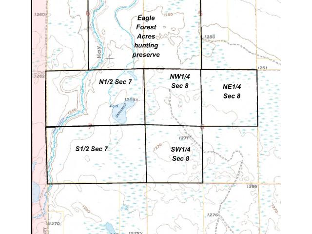
The north half of Sec 7 except Red Lake Indian Reservation, 7-150-32. Together with EASEMENT A, EASEMENT B, EASEMENT C, & EASEMENT D (see Supplements). Subject to easement providing access to south half of Sec 7 (not yet described). May be subject to SE Boundary Rd. Subject to any other easements, restrictions, or reservations of record. (Legal description of record to govern.)
The north half of Sec 7 except Red Lake Indian Reservation, 7-150-32. Together with EASEMENT A, EASEMENT B, EASEMENT C, & EASEMENT D (see Supplements). Subject to easement providing access to south half of Sec 7 (not yet described). May be subject to SE Boundary Rd. Subject to any other easements, restrictions, or reservations of record. (Legal description of record to govern.)
Property Location
Directions
From US Hwy 71/State Hwy 72 in Blackduck, N on State Hwy 72 approx 10 mi. Left on State Hwy 1 approx 12 mi. Left on trl approx 2 1/2 mi. (See Supplements for Driving Directions.)
From US Hwy 71/State Hwy 72 in Blackduck, N on State Hwy 72 approx 10 mi. Left on State Hwy 1 approx 12 mi. Left on trl approx 2 1/2 mi. (See Supplements for Driving Directions.)
Access
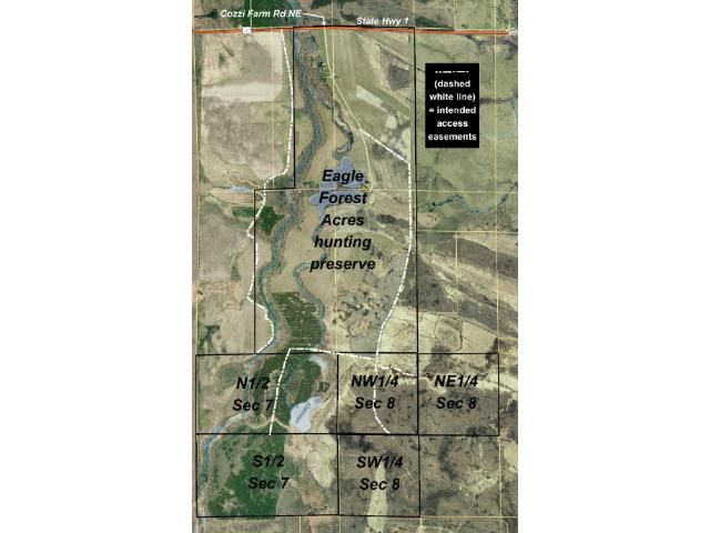
Access to the portion west of Hay Creek is via EASEMENT A, EASEMENT B, & EASEMENT C (see Supplements) from State Hwy 1 along existing trails through adjoining lands to the north. Access to the portion east of Hay Creek is via EASEMENT D (see attached file downloads) from Cozzi Farm Rd NE through adjoining land to the northeast. (Note: Southerly 500-600 ft of EASEMENT C is not constructed.) DIRECTIONS TO PORTION WEST OF HAY CREEK: From US Hwy 71/State Hwy 72 intersect in Blackduck (+/-25 mi NE of Bemidji), N on State Hwy 72 approx 10 mi. Left(W) on State Hwy 1 approx 12 mi (3/10 mile past Cozzi Farm Rd NE). Left(S) on easement trail and along tree line around field approx 2 1/2 mi into N boundary west of Hay Creek. (Note: Southerly 500-600 ft of EASEMENT C is not constructed.) DIRECTIONS TO PORTION EAST OF HAY CREEK: From US Hwy 71/State Hwy 72 intersection in Blackduck (+/-25 mi NE of Bemidji), N on State Hwy 72 approx 10 mi. Left(W) on State Hwy 1 approx 11 3/4 mi. S on Cozzi Farm Rd NE approx 7/10 mi. Left(SW & S) on trail approx 9/10 mi to four-way intersection. Cont straight(S) on trail approx 7/10 mi. Right(W) on trail approx 1/2 mi. Left(S) on trail approx 250 ft into N boundary east of Hay Creek.
Access to the portion west of Hay Creek is via EASEMENT A, EASEMENT B, & EASEMENT C (see Supplements) from State Hwy 1 along existing trails through adjoining lands to the north. Access to the portion east of Hay Creek is via EASEMENT D (see attached file downloads) from Cozzi Farm Rd NE through adjoining land to the northeast. (Note: Southerly 500-600 ft of EASEMENT C is not constructed.) DIRECTIONS TO PORTION WEST OF HAY CREEK: From US Hwy 71/State Hwy 72 intersect in Blackduck (+/-25 mi NE of Bemidji), N on State Hwy 72 approx 10 mi. Left(W) on State Hwy 1 approx 12 mi (3/10 mile past Cozzi Farm Rd NE). Left(S) on easement trail and along tree line around field approx 2 1/2 mi into N boundary west of Hay Creek. (Note: Southerly 500-600 ft of EASEMENT C is not constructed.) DIRECTIONS TO PORTION EAST OF HAY CREEK: From US Hwy 71/State Hwy 72 intersection in Blackduck (+/-25 mi NE of Bemidji), N on State Hwy 72 approx 10 mi. Left(W) on State Hwy 1 approx 11 3/4 mi. S on Cozzi Farm Rd NE approx 7/10 mi. Left(SW & S) on trail approx 9/10 mi to four-way intersection. Cont straight(S) on trail approx 7/10 mi. Right(W) on trail approx 1/2 mi. Left(S) on trail approx 250 ft into N boundary east of Hay Creek.
GPS Coordinates
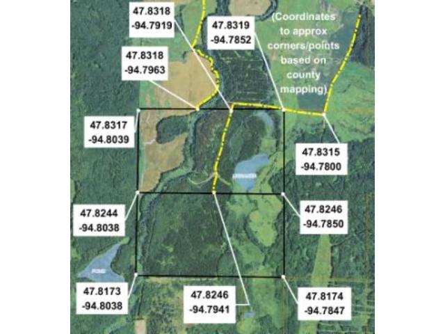
See map for coordinates to approximate corners and points based on county mapping.
See map for coordinates to approximate corners and points based on county mapping.
Address
PtN1/2Sec7 State Highway 1
PtN1/2Sec7 State Highway 1
Neighborhood
Eagle Forest Acres
Eagle Forest Acres
School District
Blackduck - 32
Blackduck - 32
Property Details
Dimensions (approx)
2657x2640x4640x4600
2657x2640x4640x4600
Utilities
Available Utilities
None
None
On Site Utilities
None
None
Power Company
Beltrami Electric (1-800-955-6083)
Beltrami Electric (1-800-955-6083)
Waterfront
Waterfront Name
N/A
N/A
Waterfront Number
999999999
999999999
Waterfront Feet (approx)
1
1
Types
Crop Type
Other
Other
Taxes & Fees
Association Fee
$0
$0
Tax Amount
$2,324
$2,324
Assessment Amount
0
0
Tax With Assessments
$2,324
$2,324
Tax Year
2016
2016
Other Details
Section Number
7
7
Township Number
150
150
Range Number
32
32
Estimated Upland %
55
55
Estimated Wetland %
45
45
Additional Comments
Hunting Comments
The subject property is near public land in MN Firearms Deer Zone 110. It ajoins Eagle Forest Acres hunting preserve, a premiere destination for pheasant, bear, and whitetail deer hunts. Ducks and partridge are also plentiful in the area.
The subject property is near public land in MN Firearms Deer Zone 110. It ajoins Eagle Forest Acres hunting preserve, a premiere destination for pheasant, bear, and whitetail deer hunts. Ducks and partridge are also plentiful in the area.
Disclosures
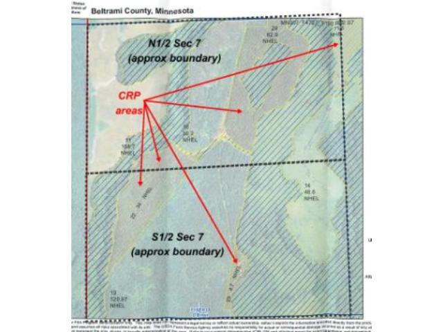
Parcel split; taxes estimated; subject to approval by Beltrami County. County tax description for the parent parcel indicates 572 total acres; however, the county's parcel information for the parent parcel indicates total calculated acreage of 563.58. Not surveyed; acreage and dimensions are approximate based on county data and mapping; county disclaimers are included by reference. Together with and subject to access easements and any other easements, restrictions, and reservations of record. (Note: Southerly 500-600 ft of EASEMENT C is not constructed.) May be subject to SE Boundary Rd along/near west side. Portions subject to CRP/farming lease agreements; see map of CRP areas and contact agent for details. Portions within 300 feet of Hay Creek are subject to Beltrami County Shoreland Management Ordinance. Photos/maps are for convenience only and not guaranteed; tree cover may be different than depicted; physically inspect prior to purchase.
Parcel split; taxes estimated; subject to approval by Beltrami County. County tax description for the parent parcel indicates 572 total acres; however, the county's parcel information for the parent parcel indicates total calculated acreage of 563.58. Not surveyed; acreage and dimensions are approximate based on county data and mapping; county disclaimers are included by reference. Together with and subject to access easements and any other easements, restrictions, and reservations of record. (Note: Southerly 500-600 ft of EASEMENT C is not constructed.) May be subject to SE Boundary Rd along/near west side. Portions subject to CRP/farming lease agreements; see map of CRP areas and contact agent for details. Portions within 300 feet of Hay Creek are subject to Beltrami County Shoreland Management Ordinance. Photos/maps are for convenience only and not guaranteed; tree cover may be different than depicted; physically inspect prior to purchase.
Additional Details
Waterfront Comments:
Hay Creek, which is considered a Tributary River Segment, weaves diagonally through the west half of this property; there is about 4,300 feet of preserved forested frontage along the creek. There is also approximately 2,200 feet of stream connecting the two ponds (one is approx 1.5 acres & the other is approx 14 acres) in the east half. Portions of the land within 300 feet of the creek or stream are subject to Beltrami County Shoreland Management Ordinance.
Hay Creek, which is considered a Tributary River Segment, weaves diagonally through the west half of this property; there is about 4,300 feet of preserved forested frontage along the creek. There is also approximately 2,200 feet of stream connecting the two ponds (one is approx 1.5 acres & the other is approx 14 acres) in the east half. Portions of the land within 300 feet of the creek or stream are subject to Beltrami County Shoreland Management Ordinance.


