
MLS Number : 4899706
Sold $295,000 - Hunting & Recreation, Waterfront Properties
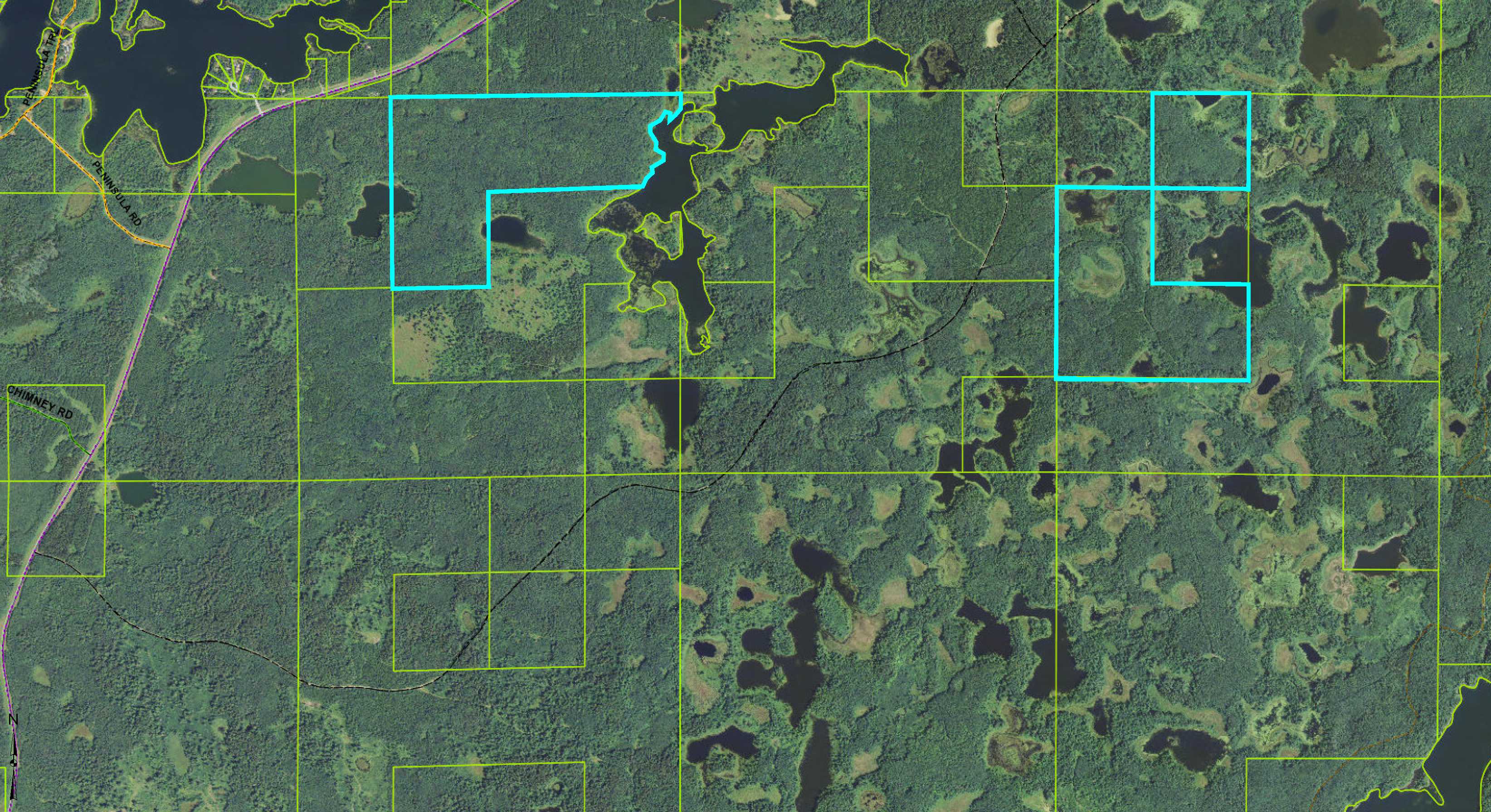
Potlatch land on Stassen Lake and various ponds northwest of Park Rapids. Varying topography combines upland with wetlands, open water ponds, and approx 1,676 ft of lake frontage. Access via easements off CR39 and Anchor Hill Rd.
Main Property Info
Property ID
210270200 & Pt 210290100
210270200 & Pt 210290100
MLS Number
4899706
4899706
Status
Sold
Sold
List Price
$359,800
$359,800
Selling Price
$295,000
$295,000
Acres
313
313
Zoning
Portions w/in 1000 ft of Stassen Lake subject to Shoreland Mgmt Ordinance; remainder not zoned
Portions w/in 1000 ft of Stassen Lake subject to Shoreland Mgmt Ordinance; remainder not zoned
City
Bagley
Bagley
Township
Long Lost Lake Twp
Long Lost Lake Twp
State
MN
MN
Zip Code
56621
56621
County
Clearwater
Clearwater
Legal Description
N2SW & NENW & SWNW, 27-143-37 and GL2(NENE) & E2NW & NWNE, 29-143-37. Tog w/ easements over SWSE, 20-143-37 & SENE, 28-143-37. Subj to ease, restrict, reserv of record.
N2SW & NENW & SWNW, 27-143-37 and GL2(NENE) & E2NW & NWNE, 29-143-37. Tog w/ easements over SWSE, 20-143-37 & SENE, 28-143-37. Subj to ease, restrict, reserv of record.
Property Location
Directions
TO SECTION 29 LAND - From US Hwy 71 & State Hwy 113 north of Park Rapids, west on State Hwy 113 for 13.5 mi. Right on CR39 (Long Lost Lake Rd) 3.3 mi. South on easement (not constructed) 0.2 mi into north side of the property. TO SECTION 27 LAND - From US Hwy 71 & State Hwy 113 north of Park Rapids, west on State Hwy 113 for 13.5 mi. Right on CR39 (Long Lost Lake Rd) 1.3 mi. Right on Anchor Hill Rd 3.1 mi. Right on easement trail 0.2 mi into west side of the property.
TO SECTION 29 LAND - From US Hwy 71 & State Hwy 113 north of Park Rapids, west on State Hwy 113 for 13.5 mi. Right on CR39 (Long Lost Lake Rd) 3.3 mi. South on easement (not constructed) 0.2 mi into north side of the property. TO SECTION 27 LAND - From US Hwy 71 & State Hwy 113 north of Park Rapids, west on State Hwy 113 for 13.5 mi. Right on CR39 (Long Lost Lake Rd) 1.3 mi. Right on Anchor Hill Rd 3.1 mi. Right on easement trail 0.2 mi into west side of the property.
Address
Long Lost Lake Rd (Co Rd 39) & Anchor Hill Rd
Long Lost Lake Rd (Co Rd 39) & Anchor Hill Rd
School District
Bagley - 162
Bagley - 162
Property Details
Dimensions (approx)
3998 x 191 x 1676 x 2127 x 1306 x 1337 x 2647 (Sec 29 land) + 2640 x 1320 x 1320 x 1320 x 1320 x 2640 & 1320 x 1320 x 1320 x 1320 (Sec 27 land).
3998 x 191 x 1676 x 2127 x 1306 x 1337 x 2647 (Sec 29 land) + 2640 x 1320 x 1320 x 1320 x 1320 x 2640 & 1320 x 1320 x 1320 x 1320 (Sec 27 land).
Waterfront
Waterfront Name
Stassen Lake & Various Ponds
Stassen Lake & Various Ponds
Taxes & Fees
Tax Amount
$2,354
$2,354
Assessment Amount
0
0
Tax With Assessments
$2,354
$2,354
Tax Year
2017
2017
Other Details
Section Number
27 & 29
27 & 29
Township Number
143
143
Range Number
37
37
Additional Comments
Disclosures
Parcel split; acreage, dimensions, and taxes estimated based on county data and mapping; county disclaimers included by reference; subject to split approval if necessary. Not surveyed. Photos/maps for convenience only and not guaranteed; physically inspect prior to purchase. Any deer stands on the land are not property of seller and are not included in sale. Use seller-approved PA and addendum; closing dates the 3rd Wednesday each month.
Parcel split; acreage, dimensions, and taxes estimated based on county data and mapping; county disclaimers included by reference; subject to split approval if necessary. Not surveyed. Photos/maps for convenience only and not guaranteed; physically inspect prior to purchase. Any deer stands on the land are not property of seller and are not included in sale. Use seller-approved PA and addendum; closing dates the 3rd Wednesday each month.


