
MLS Number : 4261962
Sold $36,500 - Hunting & Recreation
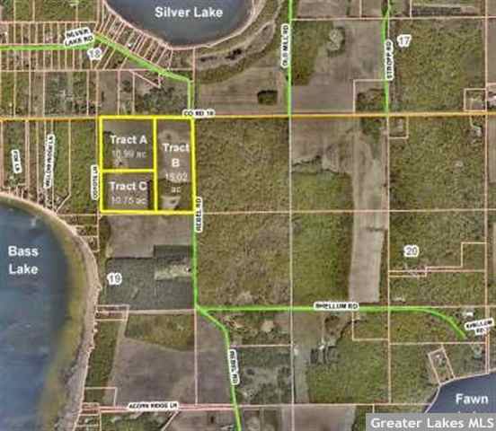
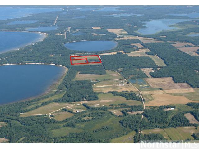
15+ acres just moments from Lake Edward, Mission Lake, & public access to Mississippi River. Surveyed tract has mostly level terrain, wooded & open areas, paved county rd access. Affordably priced for great location in the Brainerd/Baxter lakes area!
Main Property Info
Property ID
Pt 520191200A00009
Pt 520191200A00009
MLS Number
4261962
4261962
Status
Sold
Sold
List Price
$43,500
$43,500
Selling Price
$36,500
$36,500
Acres
15.020
15.020
Zoning
Rural Res 2.5 & Shoreland District
Rural Res 2.5 & Shoreland District
City
Merrifield
Merrifield
Township
Center Twp
Center Twp
State
MN
MN
Zip Code
56465
56465
County
Crow Wing
Crow Wing
Legal Description
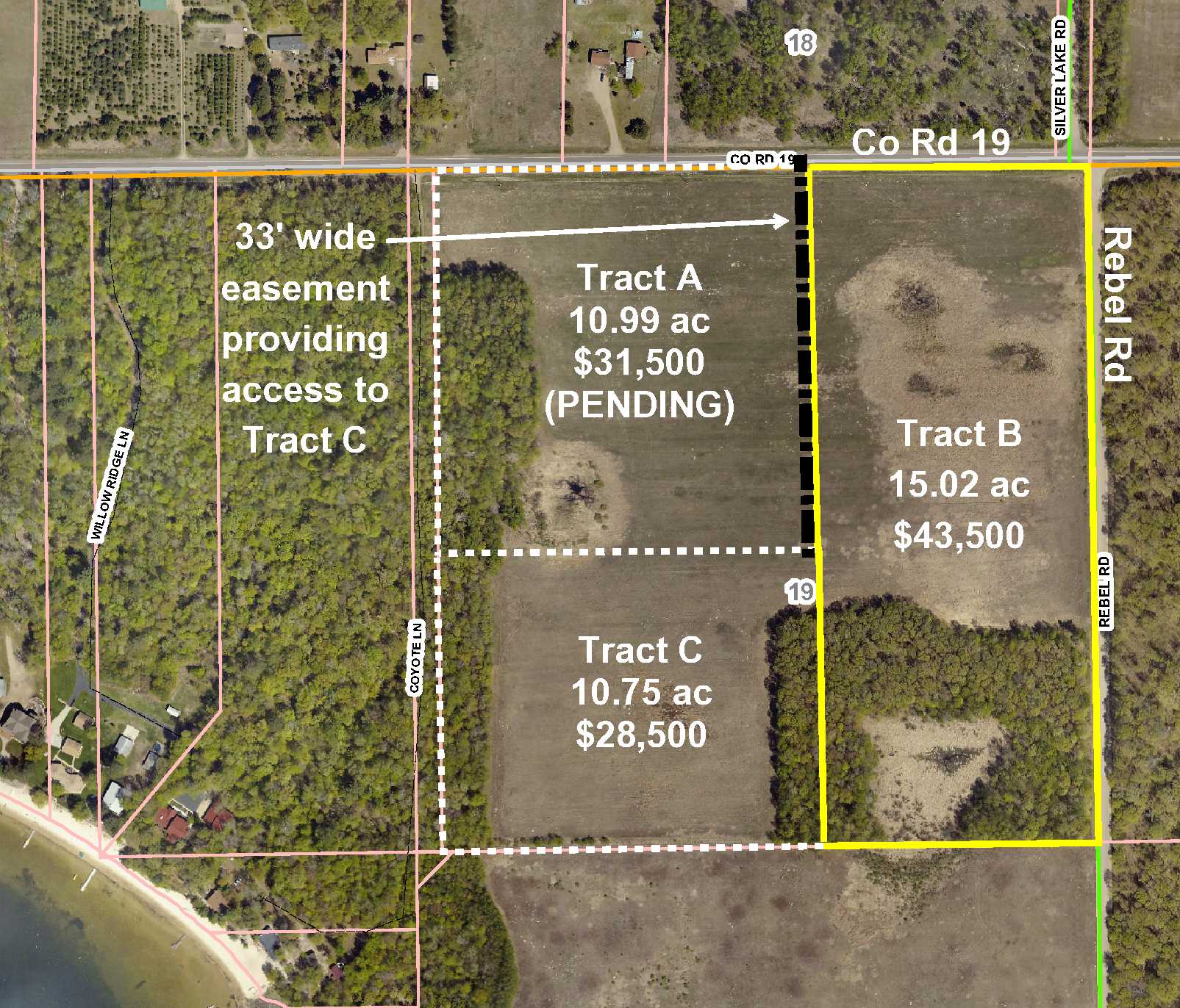
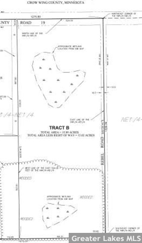
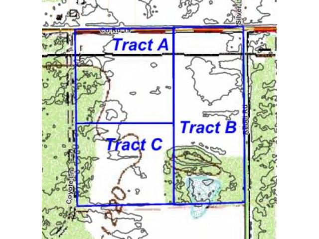
(Tract B) The east 524 ft of the NWNE, 19-135-27. Subject to Co Rd 19 and Rebel Rd. (See full description attached and on Certificate of Survey.)
(Tract B) The east 524 ft of the NWNE, 19-135-27. Subject to Co Rd 19 and Rebel Rd. (See full description attached and on Certificate of Survey.)
Property Location
Directions
From State Hwy 210 & 8th St NE/Mill Ave/CR 3 in Brainerd, N on 8th St NE for 8 1/2 mi. Right to continue on CR 3 for 2 mi. Right on CR 19 for 7/10 mi to NW corner of the tract on the right.
From State Hwy 210 & 8th St NE/Mill Ave/CR 3 in Brainerd, N on 8th St NE for 8 1/2 mi. Right to continue on CR 3 for 2 mi. Right on CR 19 for 7/10 mi to NW corner of the tract on the right.
Access
Paved Co Rd 19 runs along the north boundary and Rebel Rd runs along the east boundary of this tract.
Paved Co Rd 19 runs along the north boundary and Rebel Rd runs along the east boundary of this tract.
GPS Coordinates
Coordinates to approximate corners/points based on county mapping: NW corner along Co Rd 19 = 46.5004, -94.1282; NE corner at the intersection of Co Rd 19 and Rebel Rd = 46.5004, -94.1262; SE corner along Rebel Rd = 46.4967, -94.1261; SW corner = 46.4967, -94.1282
Coordinates to approximate corners/points based on county mapping: NW corner along Co Rd 19 = 46.5004, -94.1282; NE corner at the intersection of Co Rd 19 and Rebel Rd = 46.5004, -94.1262; SE corner along Rebel Rd = 46.4967, -94.1261; SW corner = 46.4967, -94.1282
Address
Tract B County Road 19
Tract B County Road 19
School District
Brainerd - 181
Brainerd - 181
Property Details
Dimensions (approx)
1328x1330x524x524
1328x1330x524x524
Utilities
Available Utilities
Electric,Telephone
Electric,Telephone
On Site Utilities
None
None
Power Company
Crow Wing Power (1-800-648-9401)
Crow Wing Power (1-800-648-9401)
Taxes & Fees
Association Fee
$0
$0
Tax Amount
$227
$227
Tax With Assessments
$349
$349
Tax Year
2015
2015
Other Details
Section Number
19
19
Township Number
135
135
Range Number
27
27
Estimated Upland %
85
85
Estimated Wetland %
15
15
Additional Comments
Timber Comments
This property has been managed according to Forest Stewardship Council (FSC) standards. If timber value is important to you, seek the advice of a competent forester to determine species, volumes and values.
This property has been managed according to Forest Stewardship Council (FSC) standards. If timber value is important to you, seek the advice of a competent forester to determine species, volumes and values.
Hunting Comments
Whitetail deer, small game, and waterfowl flourish in this rich environment of lakes, woods, and wetlands.
Whitetail deer, small game, and waterfowl flourish in this rich environment of lakes, woods, and wetlands.
Disclosures
Owner/broker. Subject to special assessments of $122/year through 2031 for Rebel Road/Sorenson Road paving. See survey for exact dimensions. Total acreage of the tract is 15.99 acres per Certificate of Survey; acreage represented (15.02) excludes right-of-ways. Parcel split; taxes estimated based on county data and mapping; county disclaimers included by reference; subject to split approval. Photos/maps for convenience only and not guaranteed; tree cover may be different than depicted; physically inspect prior to purchase.
Owner/broker. Subject to special assessments of $122/year through 2031 for Rebel Road/Sorenson Road paving. See survey for exact dimensions. Total acreage of the tract is 15.99 acres per Certificate of Survey; acreage represented (15.02) excludes right-of-ways. Parcel split; taxes estimated based on county data and mapping; county disclaimers included by reference; subject to split approval. Photos/maps for convenience only and not guaranteed; tree cover may be different than depicted; physically inspect prior to purchase.


