


MLS Number : 5576538
Sold $123,900 - Home & Cabin Sites, Hunting & Recreation
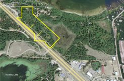
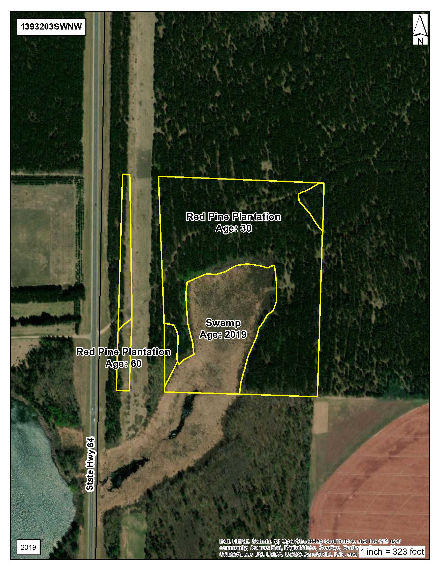
This 72.54 acre property has gentle rolling topography with some low land in the southwest corner and a 30 to 60-year old mature Potlatch Red Pine plantation. Near Akeley it lies in prime Whitetail hunting country! Added outdoor enjoyment includes nearby boat access on Nagle and Mow Lakes, the Badoura State Forest and several WMAs and AMAs too. A great setting for hunting or homesite privacy and the outdoor enthusiast. Convenient access off of State Hwy 64.
Main Property Info
Property ID
030301100 & 030301000
030301100 & 030301000
MLS Number
5576538
5576538
Status
Sold
Sold
List Price
$123,900
$123,900
Selling Price
$123,900
$123,900
Acres
72.54
72.54
Zoning
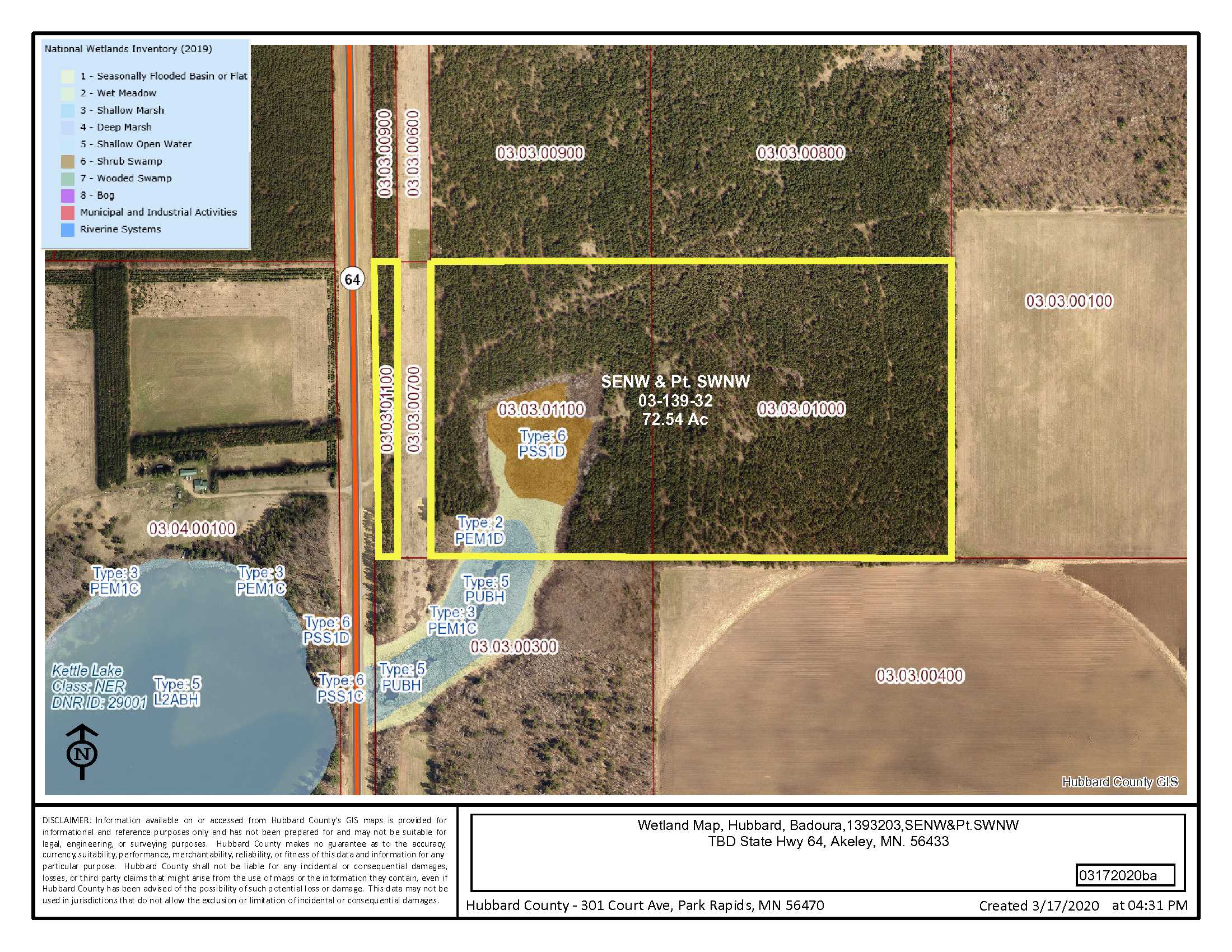
SW corner is zoned Shoreland
SW corner is zoned Shoreland
City
Akeley
Akeley
Township
Badoura Twp
Badoura Twp
State
MN
MN
Zip Code
56433
56433
County
Hubbard
Hubbard
Legal Description
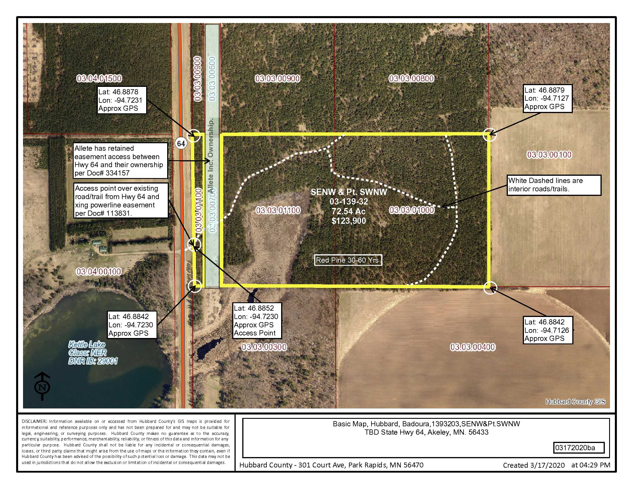
See EXHIBIT A SUMMARIZED LEGAL DESCRIPTION in Supplements. Pt. SWNW & SENW, 03-139-32, Hubbard County. Subject to easements, restrictions and reservations of record.
See EXHIBIT A SUMMARIZED LEGAL DESCRIPTION in Supplements. Pt. SWNW & SENW, 03-139-32, Hubbard County. Subject to easements, restrictions and reservations of record.
Property Location
Directions
From Akeley MN at the intersection of Hwy 34 (Broadway) and Hwy 64, go south on Hwy 64 8.2 miles to access on the left (East). (Approximate GPS: Lat: 46.8852, Lon: -94.7230.)
From Akeley MN at the intersection of Hwy 34 (Broadway) and Hwy 64, go south on Hwy 64 8.2 miles to access on the left (East). (Approximate GPS: Lat: 46.8852, Lon: -94.7230.)
Access
Paved State Hwy #64. (Approx GPS: Lat: 46.8852, Lon: -94.7230.)
Paved State Hwy #64. (Approx GPS: Lat: 46.8852, Lon: -94.7230.)
GPS Coordinates
Coordinates to approximate corners/points based on county mapping: NW: Lat: 46.8878, Lon: -94.7231 NE: Lat: 46.8879, Lon: -94.7127 SE: Lat: 46.8842, Lon: -94.7126 SW: Lat: 46.8842, Lon: -94.7230
Coordinates to approximate corners/points based on county mapping: NW: Lat: 46.8878, Lon: -94.7231 NE: Lat: 46.8879, Lon: -94.7127 SE: Lat: 46.8842, Lon: -94.7126 SW: Lat: 46.8842, Lon: -94.7230
Address
TBD State Hwy #64, Akeley, MN 56433
TBD State Hwy #64, Akeley, MN 56433
School District
Walker-Hackensack-Akeley - 113
Walker-Hackensack-Akeley - 113
Property Details
Pasture Acres
0
0
Tillable Acres
0
0
Wooded Acres
64.54
64.54
Dimensions (approx)
2460’ X 1330’ X 2460’ X 1330’
2460’ X 1330’ X 2460’ X 1330’
Utilities
Available Utilities
Electric and telephone nearby
Electric and telephone nearby
On Site Utilities
None
None
Power Company
Itasca-Mantrap Co-op (1-888-713-3377)
Itasca-Mantrap Co-op (1-888-713-3377)
Waterfront
Waterfront Name
N/A
N/A
Waterfront Number
N/A
N/A
Waterfront Feet (approx)
N/A
N/A
Taxes & Fees
Has Association Fee
No
No
Association Fee
$0
$0
Association Fee Includes
N/A
N/A
Tax Amount
$690
$690
Assessment Amount
0
0
Tax With Assessments
$690
$690
Assessment Pending
No
No
Assessment Description
N/A
N/A
Tax Year
2020
2020
Other Details
Section Number
03
03
Township Number
139
139
Range Number
32
32
Estimated Upland %
89
89
Estimated Wetland %
11
11
Additional Comments
Timber Comments
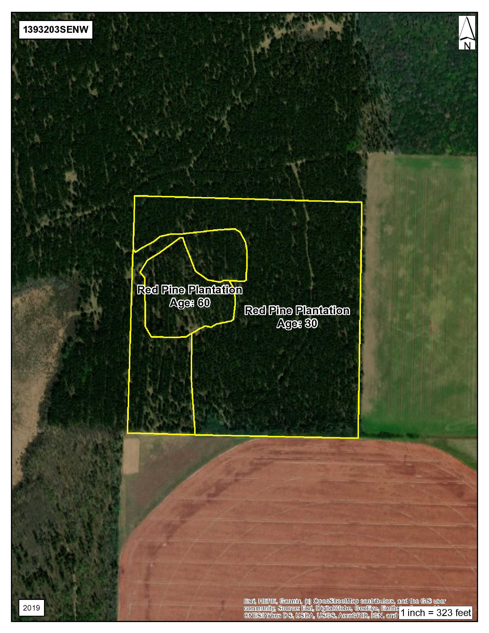
30 to 60-year old Red Pine Plantation This property has been managed according to Forest Stewardship Council (FSC) standards. If Timber value is important to you, seek the advice of a competent forester to determine species, volumes and values.
30 to 60-year old Red Pine Plantation This property has been managed according to Forest Stewardship Council (FSC) standards. If Timber value is important to you, seek the advice of a competent forester to determine species, volumes and values.
Hunting Comments
Deer Permit Area: 259
Deer Permit Area: 259
Disclosures
Easement(s) affect this property. See legal description and maps for details. Shared easements affect this property and easements granted and reserved/retained will include terms governing shared use of the easements. See legal description and maps for details. Acreage, dimensions, and taxes estimated based on county data and mapping or seller data; county disclaimers included by reference; subject to split approval if necessary. Not surveyed. Photos/maps and GPS coordinates for convenience only and not guaranteed; physically inspect prior to purchase. Any deer stands on the land are not property of seller and are not included in sale. Use seller-approved PA and addendum; closing dates the 3rd Wednesday each month. Seller is Potlatch Minnesota Timberlands LLC, a business entity under the laws of the State of Delaware.
Easement(s) affect this property. See legal description and maps for details. Shared easements affect this property and easements granted and reserved/retained will include terms governing shared use of the easements. See legal description and maps for details. Acreage, dimensions, and taxes estimated based on county data and mapping or seller data; county disclaimers included by reference; subject to split approval if necessary. Not surveyed. Photos/maps and GPS coordinates for convenience only and not guaranteed; physically inspect prior to purchase. Any deer stands on the land are not property of seller and are not included in sale. Use seller-approved PA and addendum; closing dates the 3rd Wednesday each month. Seller is Potlatch Minnesota Timberlands LLC, a business entity under the laws of the State of Delaware.