
MLS Number : 4727212
Sold $95,000 - Hunting & Recreation, Price Reduced
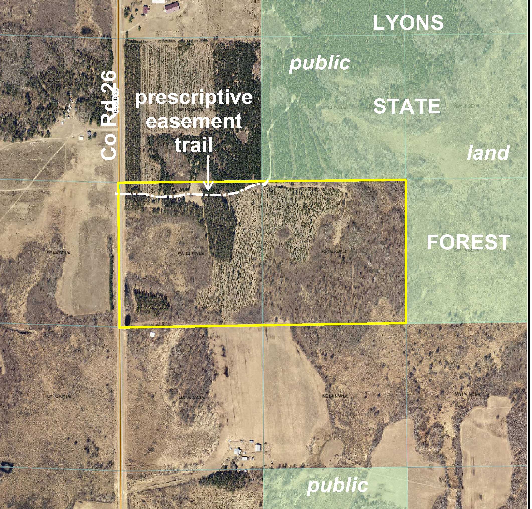
Price lowered from $109,900 to $99,500! Potlatch land adjoining public Lyons State Forest land northwest of Staples. Fairly level upland topography with spots of wetlands in the center of the westerly “40” and along the south part of the easterly “40.” Mixture of aspen, red pine, and northern hardwoods. Paved county road along the west side and a prescriptive easement trail along portion of the north side provides access into the tract. Leaf River a few miles to the south; Crow Wing River a few miles to the east.
Main Property Info
Property ID
030053010
030053010
MLS Number
4727212
4727212
Status
Sold
Sold
List Price
$99,500
$99,500
Selling Price
$95,000
$95,000
Acres
80
80
Zoning
A-2 Mixed Agriculture
A-2 Mixed Agriculture
City
Verndale
Verndale
Township
Bullard Twp
Bullard Twp
State
MN
MN
Zip Code
56481
56481
County
Wadena
Wadena
Legal Description
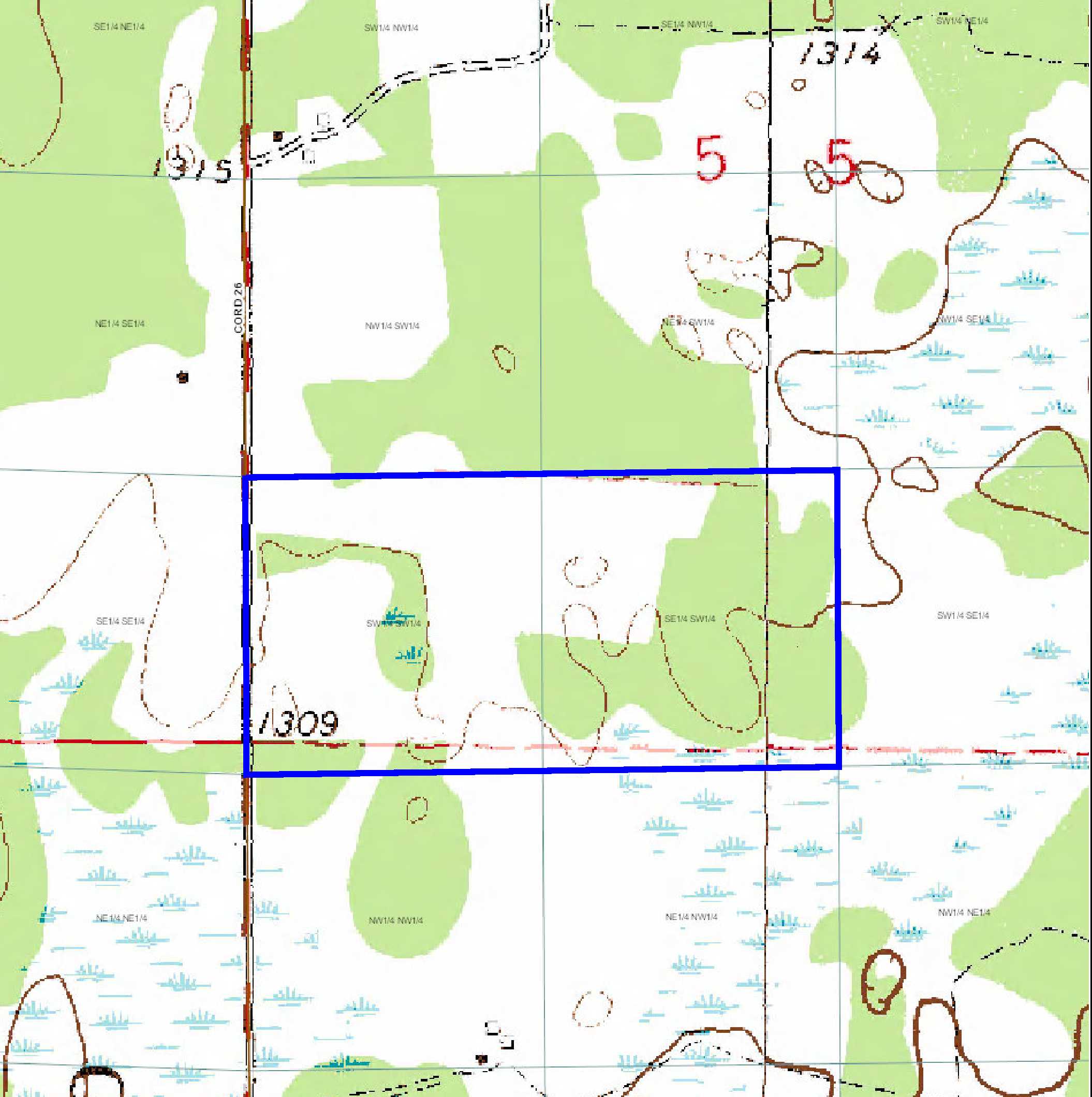
SESW & SWSW, 5-135-33. Subject to Co Rd 26, prescriptive easement in Doc# 243849, and any other easements, restrictions, or reservations of record.
SESW & SWSW, 5-135-33. Subject to Co Rd 26, prescriptive easement in Doc# 243849, and any other easements, restrictions, or reservations of record.
Property Location
Directions
From intersection of US Hwy 10 & Co Rd 26 between Staples and Aldrich, north on Co Rd 26 for 6 3/10 miles. Left to stay on Co Rd 26 for 5 6/10 miles to easement trail on right leading into the property. (OR, from the intersection of State Hwy 227 and Co Rd 26 in Nimrod, south on Co Rd 26 for 6 9/10 miles to easement trail on left leading into the property.)
From intersection of US Hwy 10 & Co Rd 26 between Staples and Aldrich, north on Co Rd 26 for 6 3/10 miles. Left to stay on Co Rd 26 for 5 6/10 miles to easement trail on right leading into the property. (OR, from the intersection of State Hwy 227 and Co Rd 26 in Nimrod, south on Co Rd 26 for 6 9/10 miles to easement trail on left leading into the property.)
Access
Paved Co Rd 26 along the west side and a prescriptive easement trail along portion of the north side provides access into the tract.
Paved Co Rd 26 along the west side and a prescriptive easement trail along portion of the north side provides access into the tract.
GPS Coordinates
Coordinates to approximate corners and points based on county mapping and field flagging: point where prescriptive easement trail off Co Rd 26 enters west side (near the NW corner) = 46.5314, -94.8844; NW corner along Co Rd 26 = 46.5317, -94.8845; point where prescriptive easement trail exits north boundary = 46.5318, -94.8791; NE corner = 46.5318, -94.8740; SE corner = 46.5282, -94.8739; point along south line at edge of wetland = 46.5282, -94.8755; SW corner along Co Rd 26 = 46.5282, -94.8844.
Coordinates to approximate corners and points based on county mapping and field flagging: point where prescriptive easement trail off Co Rd 26 enters west side (near the NW corner) = 46.5314, -94.8844; NW corner along Co Rd 26 = 46.5317, -94.8845; point where prescriptive easement trail exits north boundary = 46.5318, -94.8791; NE corner = 46.5318, -94.8740; SE corner = 46.5282, -94.8739; point along south line at edge of wetland = 46.5282, -94.8755; SW corner along Co Rd 26 = 46.5282, -94.8844.
Address
County Road 26
County Road 26
School District
Verndale - 818
Verndale - 818
Property Details
Dimensions (approx)
1320 x 2640 x 1320 x 2640
1320 x 2640 x 1320 x 2640
Utilities
Power Company
Todd-Wadena Electric (1-800-320-8932)
Todd-Wadena Electric (1-800-320-8932)
Taxes & Fees
Tax Amount
$1,354
$1,354
Tax With Assessments
$1,354
$1,354
Tax Year
2016
2016
Other Details
Section Number
5
5
Township Number
135
135
Range Number
33
33
Estimated Upland %
90
90
Estimated Wetland %
10
10
Additional Comments
Timber Comments
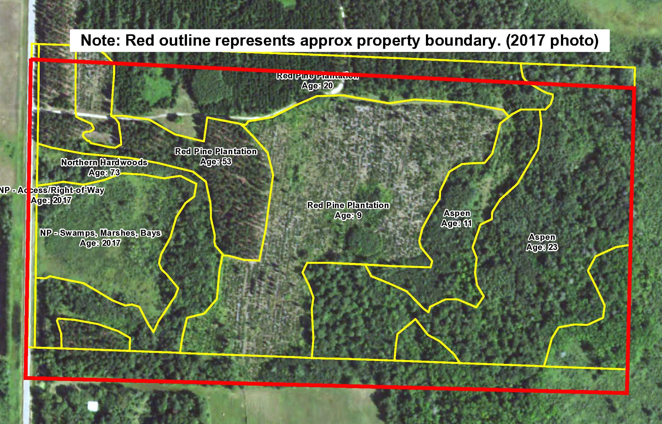
This property has been managed according to Forest Stewardship Council (FSC) standards. Timber includes aspen, red pine, and northern hardwoods. If timber value is important to you, seek the advice of a competent forester to determine species, volumes and values.
This property has been managed according to Forest Stewardship Council (FSC) standards. Timber includes aspen, red pine, and northern hardwoods. If timber value is important to you, seek the advice of a competent forester to determine species, volumes and values.
Hunting Comments
This property adjoins public land in MN Firearms Deer Zone 246.
This property adjoins public land in MN Firearms Deer Zone 246.
Disclosures
There is a small fence encroachment on the south line in the southwest corner. Not surveyed; acreage and dimensions approximate based on county data and mapping; county disclaimers included by reference. Photos/maps for convenience only and not guaranteed; tree cover may be different than depicted; physically inspect prior to purchase. Any deer stands on the land are not property of seller and are not included in sale. Use seller-approved PA and addendum; closing dates the 2nd Wednesday each month.
There is a small fence encroachment on the south line in the southwest corner. Not surveyed; acreage and dimensions approximate based on county data and mapping; county disclaimers included by reference. Photos/maps for convenience only and not guaranteed; tree cover may be different than depicted; physically inspect prior to purchase. Any deer stands on the land are not property of seller and are not included in sale. Use seller-approved PA and addendum; closing dates the 2nd Wednesday each month.


