

MLS Number : 4652282
Sold $52,500 - Hunting & Recreation, Price Reduced, Waterfront Properties
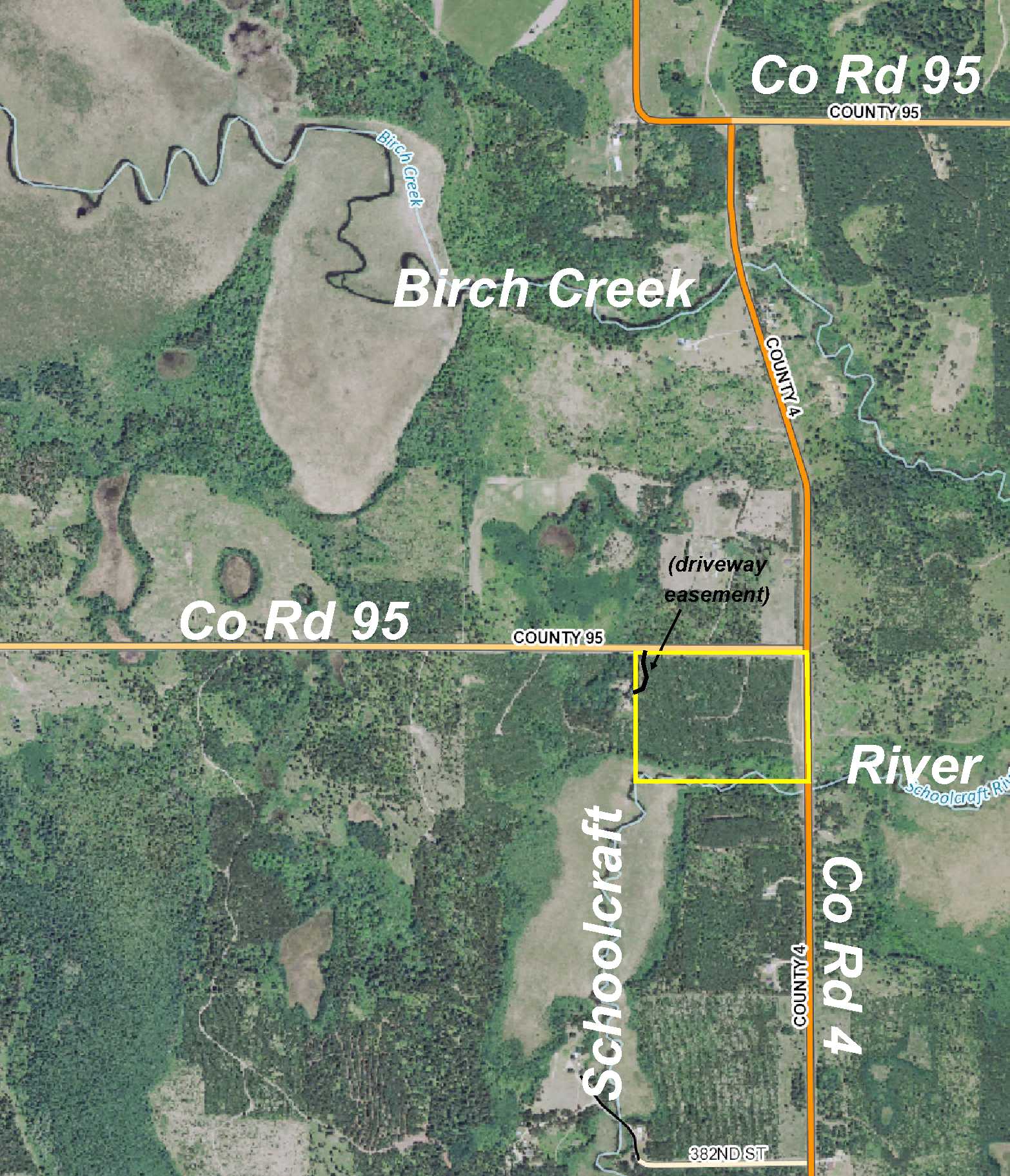
Price lowered from $59,900 to $55,500! Remote parcel of Potlatch land within Paul Bunyan State Forest bounds just a few miles from Lake George northeast of Park Rapids and west of Laporte. Tract has been surveyed. The land steeply slopes to Schoolcraft River along south side. Access via paved CR 4 along east and unpaved CR 95 along north. Hundreds of acres of public land 1/4 mile to the west for lots of hunting/recreational space, and public boat access to Lake George and Lake Paine are only a few miles away.
Main Property Info
Property ID
170800800
170800800
MLS Number
4652282
4652282
Status
Sold
Sold
List Price
$55,500
$55,500
Selling Price
$52,500
$52,500
Acres
30.000
30.000
Zoning
South 1/2 (approx) is in Shoreland zone of Forested River; remainder not zoned
South 1/2 (approx) is in Shoreland zone of Forested River; remainder not zoned
City
Lake George
Lake George
Township
Lake George Twp
Lake George Twp
State
MN
MN
Zip Code
56458
56458
County
Hubbard
Hubbard
Legal Description
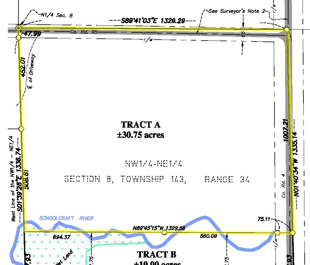
That part of the NWNE, 8-143-34, lying north of the south 327.75 ft thereof. Subject to Co Rd 4; Co Rd 95; driveway easement (not yet described); and any other easements, restrictions, reservations of record.
That part of the NWNE, 8-143-34, lying north of the south 327.75 ft thereof. Subject to Co Rd 4; Co Rd 95; driveway easement (not yet described); and any other easements, restrictions, reservations of record.
Property Location
Directions
From intersection of US Hwy 71 and State Hwy 200 approx 20 miles north of Park Rapids, northeast on US Hwy 71 for 7 3/10 miles. Left on Co Rd 4 for 2 3/10 miles to trail on left leading into the property. NE corner of the tract is at the intersection of Co Rd 4 and Co Rd 95.
From intersection of US Hwy 71 and State Hwy 200 approx 20 miles north of Park Rapids, northeast on US Hwy 71 for 7 3/10 miles. Left on Co Rd 4 for 2 3/10 miles to trail on left leading into the property. NE corner of the tract is at the intersection of Co Rd 4 and Co Rd 95.
Access
Access is via paved Co Rd 4 along the east side and unpaved Co Rd 95 along the north. There are trails off both county roads leading into the center of the property.
Access is via paved Co Rd 4 along the east side and unpaved Co Rd 95 along the north. There are trails off both county roads leading into the center of the property.
GPS Coordinates
GPS coordinates to approximate points based on county mapping: Point where trail off Co Rd 4 enters the east side = 47.2223, -95.0105; point where trail off Co Rd 95 enters the north side are 47.2250, -95.0124
GPS coordinates to approximate points based on county mapping: Point where trail off Co Rd 4 enters the east side = 47.2223, -95.0105; point where trail off Co Rd 95 enters the north side are 47.2250, -95.0124
Address
PtNWNE County Road 4
PtNWNE County Road 4
School District
Laporte - 306
Laporte - 306
Property Details
Dimensions (approx)
1007x1008x1329x1329
1007x1008x1329x1329
Utilities
Available Utilities
Electric
Electric
On Site Utilities
None
None
Power Company
Itasca-Mantrap Co-op (1-888-713-3377)
Itasca-Mantrap Co-op (1-888-713-3377)
Waterfront
Waterfront Name
Schoolcraft River
Schoolcraft River
Waterfront Number
S9990352
S9990352
Waterfront Feet (approx)
455
455
Taxes & Fees
Association Fee
$0
$0
Tax Amount
$566
$566
Tax With Assessments
$566
$566
Tax Year
2016
2016
Other Details
Section Number
8
8
Township Number
143
143
Range Number
34
34
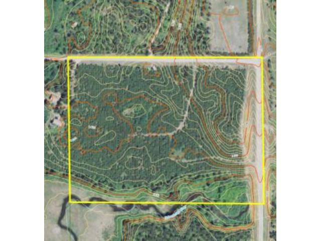
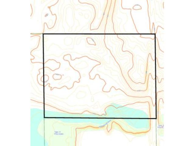
Estimated Upland %
90
90
Estimated Wetland %
10
10
Additional Comments
Timber Comments
This property has been managed according to Forest Stewardship Council (FSC) standards and is lightly wooded with red pine. If timber value is important to you, seek the advice of a competent forester to determine species, volumes and values.
This property has been managed according to Forest Stewardship Council (FSC) standards and is lightly wooded with red pine. If timber value is important to you, seek the advice of a competent forester to determine species, volumes and values.
Hunting Comments
This property is near public land.
This property is near public land.
Disclosures
Subject to driveway easement (not yet described). Acreage and dimensions based on survey. Photos/maps for convenience only and not guaranteed; tree cover may be different than depicted; physically inspect prior to purchase. Any deer stands on the land are not property of seller and are not included in sale. Use seller-approved PA and addendum; closing dates the 2nd Wednesday each month.
Subject to driveway easement (not yet described). Acreage and dimensions based on survey. Photos/maps for convenience only and not guaranteed; tree cover may be different than depicted; physically inspect prior to purchase. Any deer stands on the land are not property of seller and are not included in sale. Use seller-approved PA and addendum; closing dates the 2nd Wednesday each month.


