

MLS Number : 5249137
Sold $54,900 - Hunting & Recreation
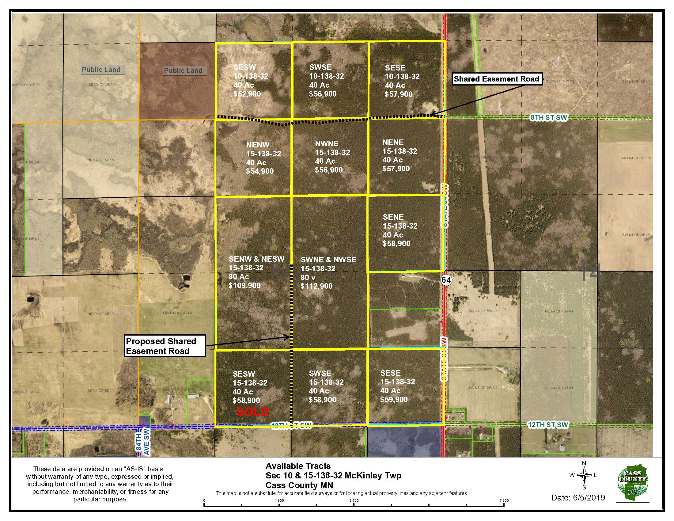
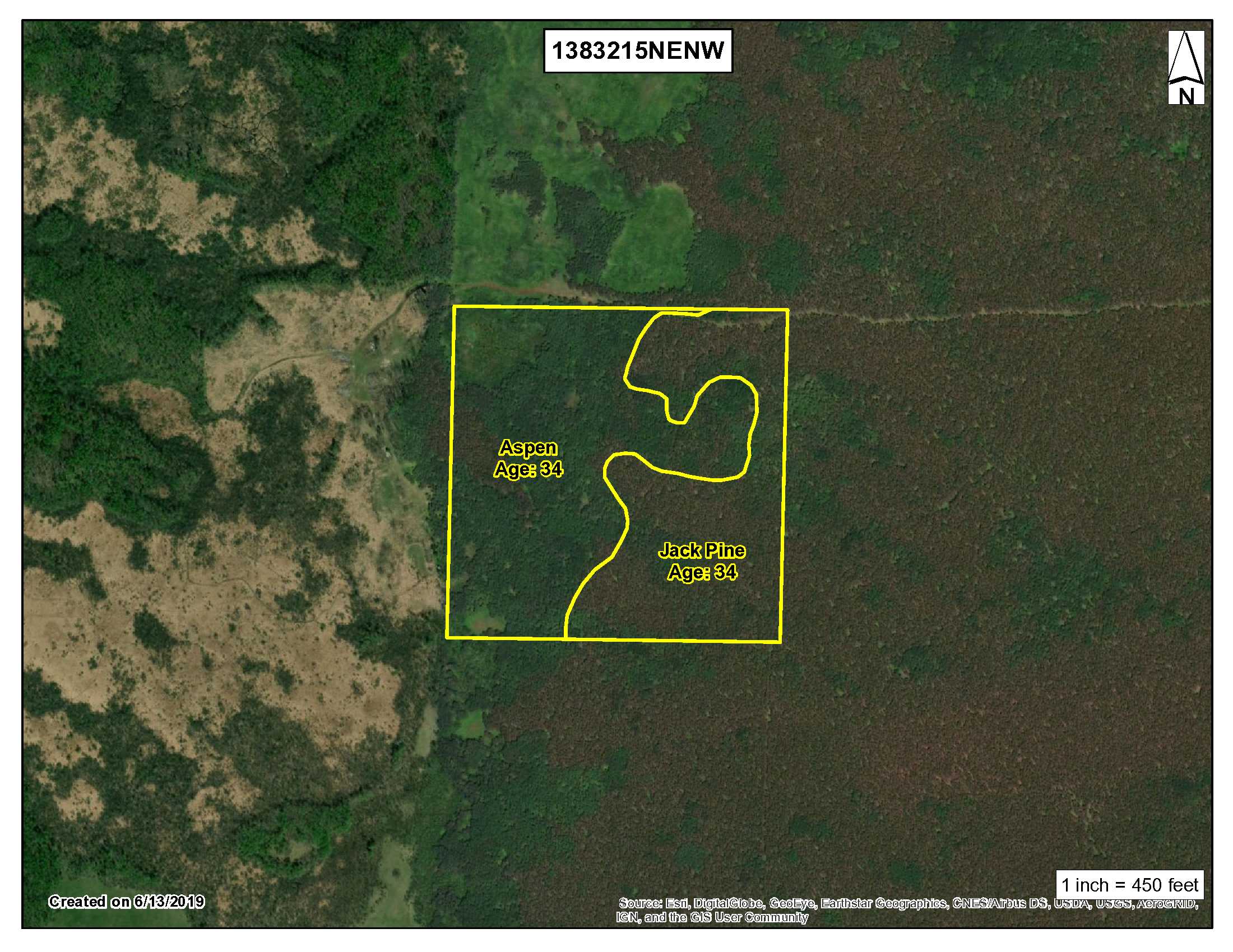
40 acres of PotlatchDeltic land features a 34-year old aspen and 34-year old jack pine forest with level terrain just west of Pine River. The mixture of timber will be excellent for deer and upland bird hunting. Access from State 64 SW is via a shared easement trail. You’ll enjoy complete privacy on the property yet you’ll be close to snowmobile trails, cross-country ski trails, ATV trails. Some of these include SnoWay 1, Spider Lake Trail, Huntersville ATV trails and more. Pine River, Backus and Jenkins are all less than a half hour away for shopping, dining, food and fuel. Large blocks of public land for hunting and recreation are less than 5 miles away in nearly any direction. Additional parcels available.
Main Property Info
Property ID
Pt of 25-015-1100
Pt of 25-015-1100
MLS Number
5249137
5249137
Status
Sold
Sold
List Price
$54,900
$54,900
Selling Price
$54,900
$54,900
Acres
40
40
Zoning
Agriculture/Forestry
Agriculture/Forestry
City
Backus
Backus
Township
McKinley Twp
McKinley Twp
State
MN
MN
Zip Code
56435
56435
County
Cass
Cass
Legal Description
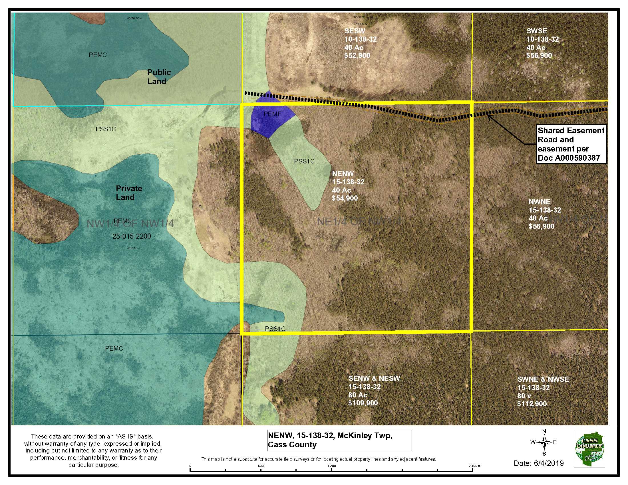
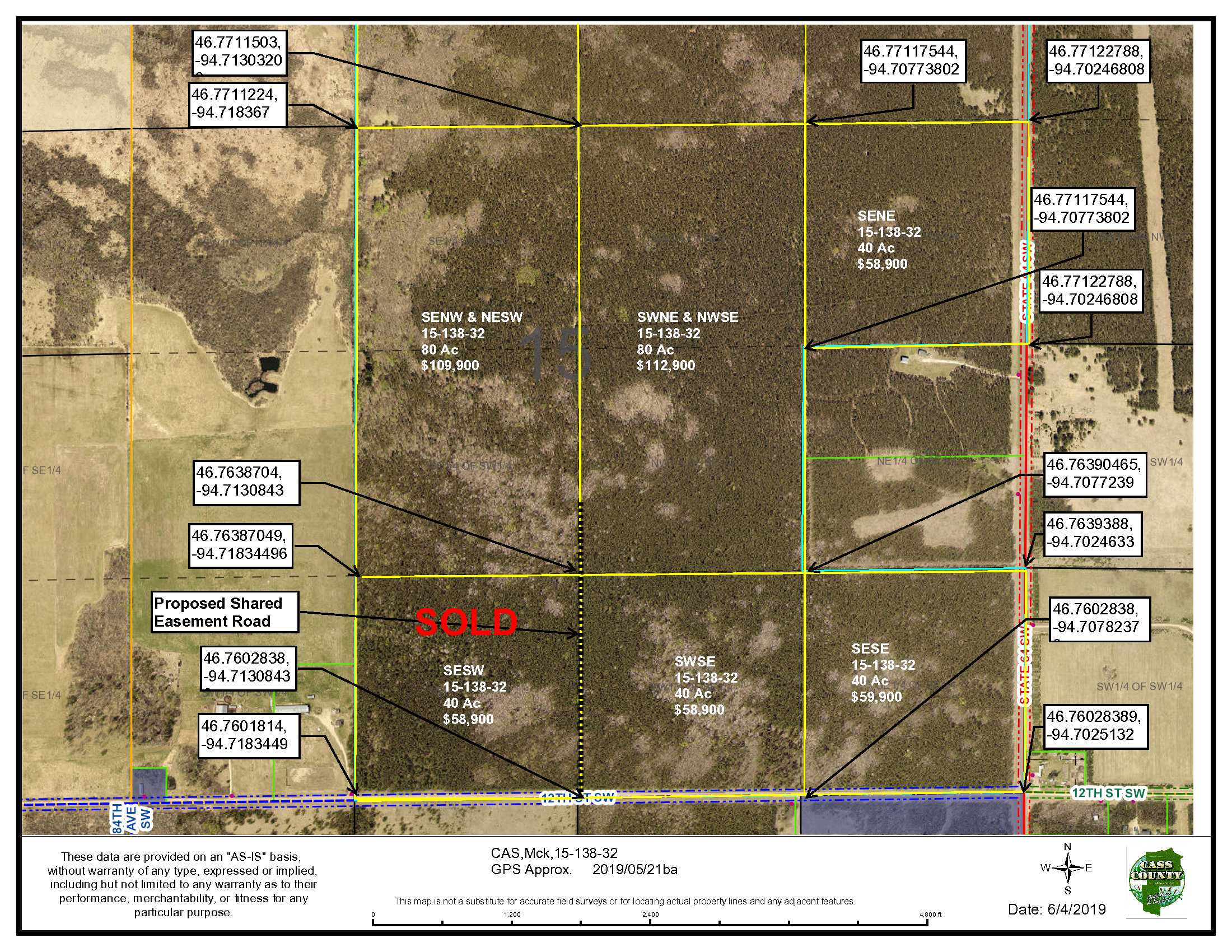
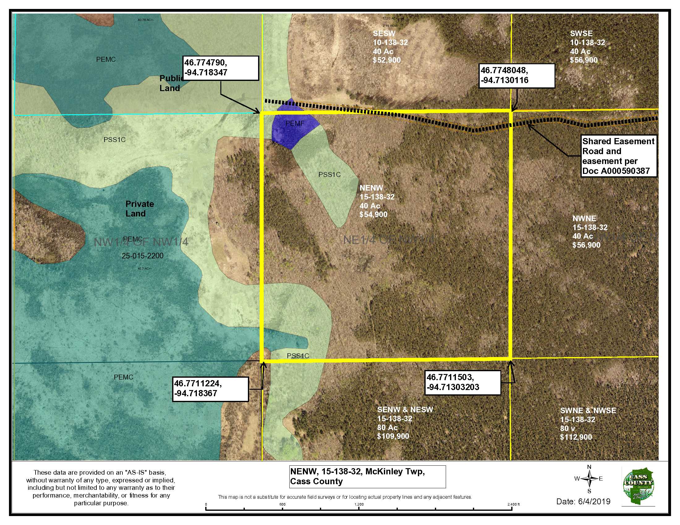
NENW, 15-138-32, Cass County, MN. Together with easement as described and shown in Exhibit A and Exhibit B. Subject to/seller to retain easement as described and shown in Exhibit A and Exhibit B. Subject to easement in Doc A000590387 and any other easements, restrictions, or reservations of record. Note: Easement(s) granted and/or retained will include terms governing shared use of the easement(s).
NENW, 15-138-32, Cass County, MN. Together with easement as described and shown in Exhibit A and Exhibit B. Subject to/seller to retain easement as described and shown in Exhibit A and Exhibit B. Subject to easement in Doc A000590387 and any other easements, restrictions, or reservations of record. Note: Easement(s) granted and/or retained will include terms governing shared use of the easement(s).
Property Location
Directions
From the traffic light in Pine River on Hwy 371 (intersection of Hwy 371 & Barclay Ave), Westerly on Barclay Ave to intersection with 24th St SW (aka Co Rd 2); West on 24th St SW/Co Rd 2 for 14 miles to State 64 SW; North on State 64 SW for 4 miles to trail on the West side of State 64 SW, West on the trail ½ mile to the NE corner of this parcel.
From the traffic light in Pine River on Hwy 371 (intersection of Hwy 371 & Barclay Ave), Westerly on Barclay Ave to intersection with 24th St SW (aka Co Rd 2); West on 24th St SW/Co Rd 2 for 14 miles to State 64 SW; North on State 64 SW for 4 miles to trail on the West side of State 64 SW, West on the trail ½ mile to the NE corner of this parcel.
Access
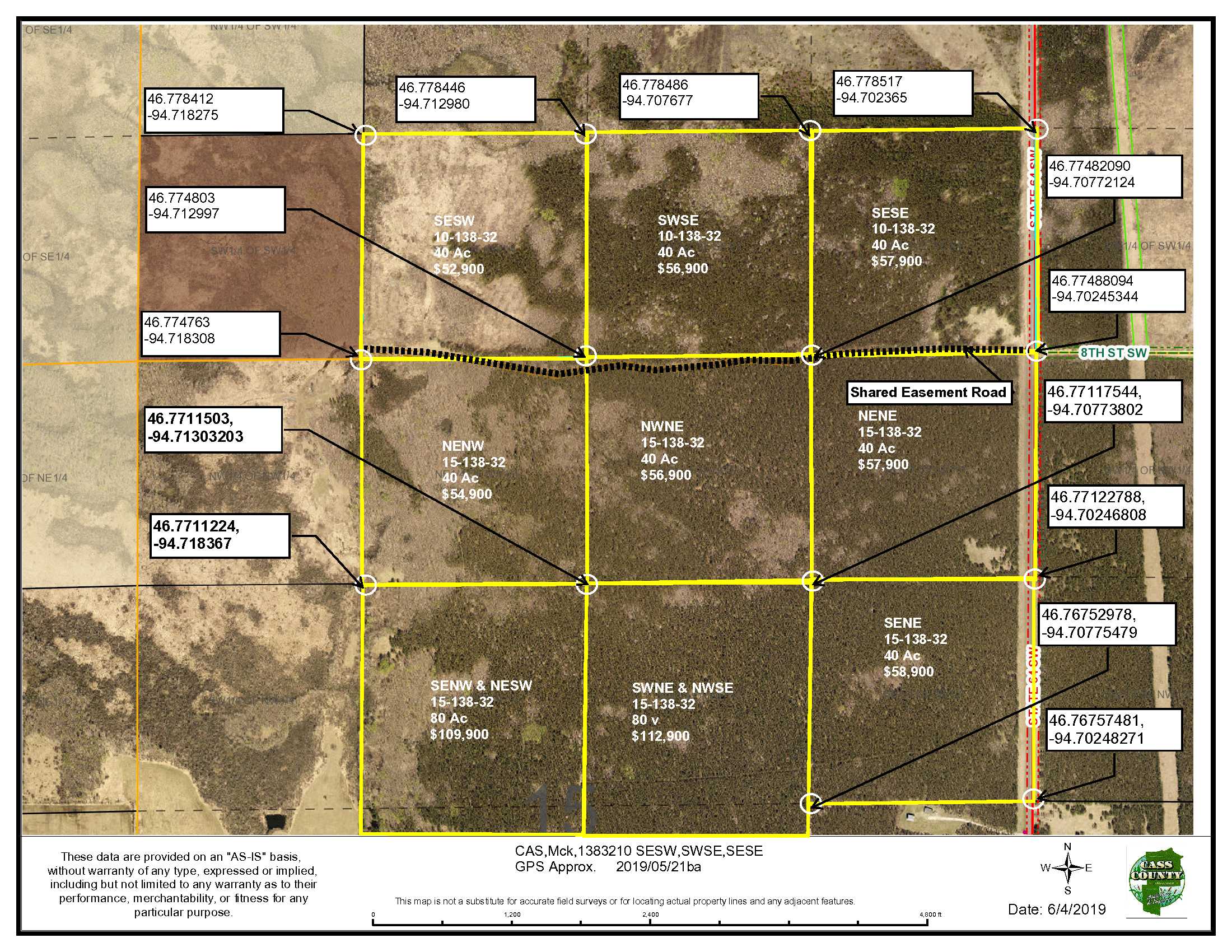
State Hwy 64 SW provides primary access. A shared easement road provides access to the NE’ly portion of the property.
State Hwy 64 SW provides primary access. A shared easement road provides access to the NE’ly portion of the property.
GPS Coordinates
Coordinates to approximate corners/points based on county mapping: NW: 46.774790, -94.718347 NE: 46.7748048, -94.7130116 SE: 46.7711503, -94.71303203 SW: 46.7711224, -94.718367
Coordinates to approximate corners/points based on county mapping: NW: 46.774790, -94.718347 NE: 46.7748048, -94.7130116 SE: 46.7711503, -94.71303203 SW: 46.7711224, -94.718367
Address
TBD NENW off State 64 SW, Backus
TBD NENW off State 64 SW, Backus
School District
Pine River-Backus - 2174
Pine River-Backus - 2174
Property Details
Pasture Acres
0
0
Wooded Acres
39
39
Dimensions (approx)
1320 x 1320 x 1320 x 1320
1320 x 1320 x 1320 x 1320
Utilities
Available Utilities
None
None
On Site Utilities
None
None
Power Company
Todd-Wadena Electric (1-800-320-8932)
Todd-Wadena Electric (1-800-320-8932)
Waterfront
Waterfront Name
None
None
Waterfront Number
None
None
Waterfront Feet (approx)
None
None
Taxes & Fees
Has Association Fee
No
No
Association Fee
$0
$0
Association Fee Includes
None
None
Tax Amount
$322
$322
Assessment Amount
0
0
Tax With Assessments
$322
$322
Assessment Pending
No
No
Assessment Description
None
None
Tax Year
2020
2020
Other Details
Section Number
15
15
Township Number
138
138
Range Number
32
32
Estimated Upland %
85
85
Estimated Wetland %
15
15
Additional Comments
Timber Comments
Predominantly jack pine and aspen. This property has been managed according to Forest Stewardship Council (FSC) standards. If timber value is important to you, seek the advice of a competent forester to determine species, volumes and values.
Predominantly jack pine and aspen. This property has been managed according to Forest Stewardship Council (FSC) standards. If timber value is important to you, seek the advice of a competent forester to determine species, volumes and values.
Hunting Comments
Deer Permit Area: 246. See Deer Permit Area 246 supplement. Archery season: Sept 15-Dec 31st, 2019; Firearm season: Nov 3 – Nov 11, 2019
Deer Permit Area: 246. See Deer Permit Area 246 supplement. Archery season: Sept 15-Dec 31st, 2019; Firearm season: Nov 3 – Nov 11, 2019
Disclosures
Shared easements affect this property and easements granted and reserved/retained will include terms governing shared use of the easements. See legal description and maps for details. Acreage, dimensions, and taxes estimated based on county data and mapping or seller data; county disclaimers included by reference; subject to split approval if necessary. Not surveyed. Photos/maps and GPS coordinates for convenience only and not guaranteed; physically inspect prior to purchase. Any deer stands on the land are not property of seller and are not included in sale. Use seller-approved PA and addendum. Closing dates are the 3rd Wednesday of each month. Bearberry (Arctostaphylos uva-ursi) may be present and is a plant the DNR would like to see protected. Search bearberry for more information or see FDc12 supplement.
Shared easements affect this property and easements granted and reserved/retained will include terms governing shared use of the easements. See legal description and maps for details. Acreage, dimensions, and taxes estimated based on county data and mapping or seller data; county disclaimers included by reference; subject to split approval if necessary. Not surveyed. Photos/maps and GPS coordinates for convenience only and not guaranteed; physically inspect prior to purchase. Any deer stands on the land are not property of seller and are not included in sale. Use seller-approved PA and addendum. Closing dates are the 3rd Wednesday of each month. Bearberry (Arctostaphylos uva-ursi) may be present and is a plant the DNR would like to see protected. Search bearberry for more information or see FDc12 supplement.


