
MLS Number : 4950474
Sold $134,900 - Hunting & Recreation, Waterfront Properties
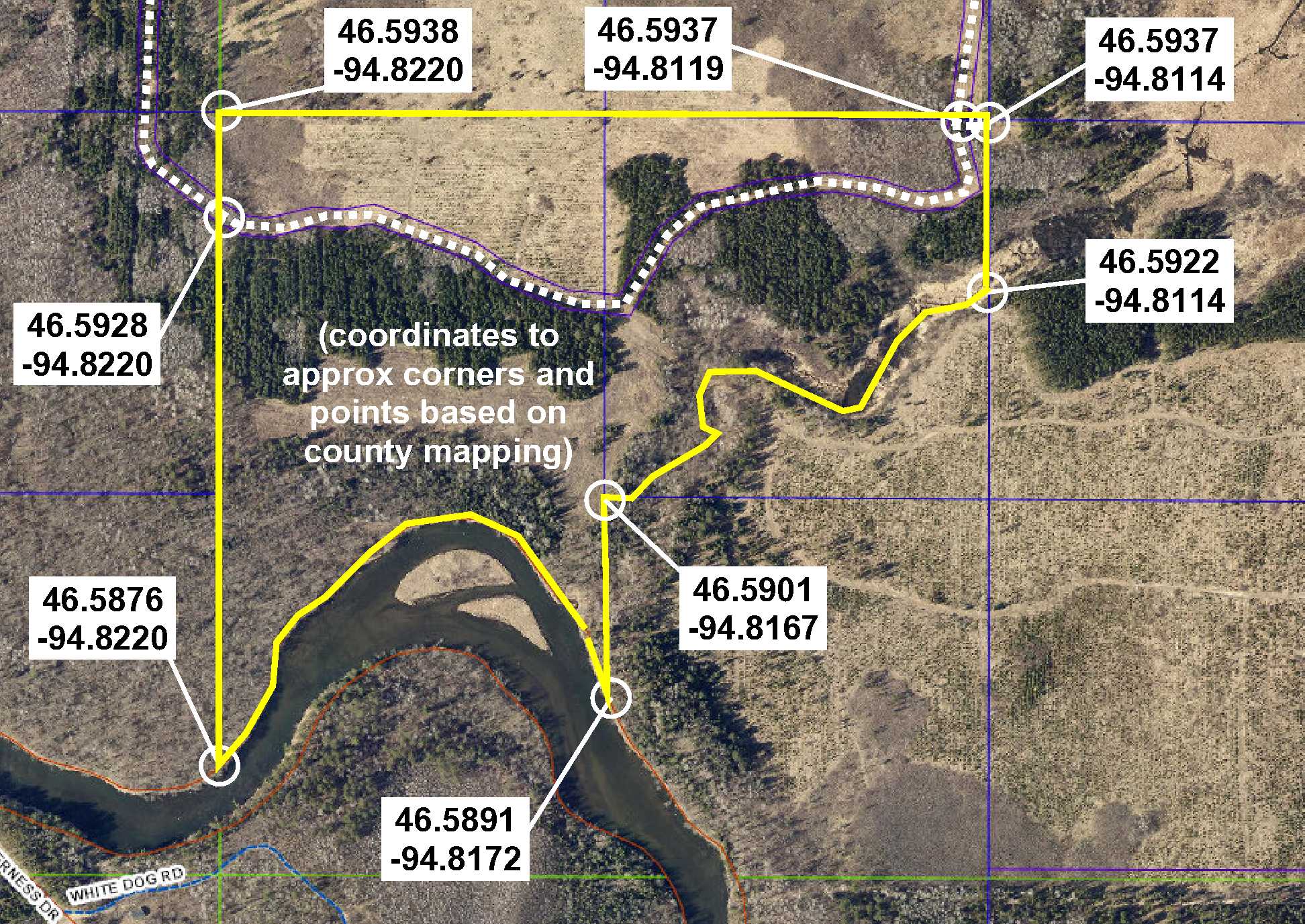
Secluded PotlatchDeltic land on the Crow Wing River southeast of Nimrod. Level and sloping topography with red pine, aspen, and swamp hardwood. Approx 2,088 ft of river frontage plus approx 1,857 ft of creek frontage. Access via gated easement trail from 271st Ave (CR140). Easement trail continues through the property. Excellent deer and waterfowl habitat for hunting. Snowmobile trail along the river offers great winter recreation too!
Main Property Info
Property ID
Pt 060143020
Pt 060143020
MLS Number
4950474
4950474
Status
Sold
Sold
List Price
$134,900
$134,900
Selling Price
$134,900
$134,900
Acres
75.8
75.8
Zoning
A-2 Mixed Agriculture & S-1 Shoreland Overlay
A-2 Mixed Agriculture & S-1 Shoreland Overlay
City
Verndale
Verndale
Township
Lyons Twp
Lyons Twp
State
MN
MN
Zip Code
56481
56481
County
Wadena
Wadena
Legal Description
GL1(NWSW) & part of NESW lying northwest of creek, 14-136-33. Subject to and together with easements. (See full description in Supplements.)
GL1(NWSW) & part of NESW lying northwest of creek, 14-136-33. Subject to and together with easements. (See full description in Supplements.)
Property Location
Directions
From the intersection of State Hwy 64 & Cass Co Rd 23 (60th St SW) north of Motley, west on Cass Co Rd 23 (60th St SW), which turns into Wadena Co Rd 7, for 5 miles. Right on Co Rd 140 (271st Ave) for 1.3 miles. Left (west and south) on easement trail (gated) 1.25 miles into north side of the property.
From the intersection of State Hwy 64 & Cass Co Rd 23 (60th St SW) north of Motley, west on Cass Co Rd 23 (60th St SW), which turns into Wadena Co Rd 7, for 5 miles. Right on Co Rd 140 (271st Ave) for 1.3 miles. Left (west and south) on easement trail (gated) 1.25 miles into north side of the property.
Access
The property is accessed via a gated easement trail from 271st Ave (Co Rd 140).
The property is accessed via a gated easement trail from 271st Ave (Co Rd 140).
GPS Coordinates
See map for coordinates to approximate corners/points based on county mapping.
See map for coordinates to approximate corners/points based on county mapping.
Address
271st Ave (Co Rd 140)
271st Ave (Co Rd 140)
School District
Sebeka - 820
Sebeka - 820
Property Details
Dimensions (approx)
2640 x 542 x 1857 x 66 x 674 x 2088 x 2253 IRR
2640 x 542 x 1857 x 66 x 674 x 2088 x 2253 IRR
Utilities
Power Company
Todd-Wadena Electric (1-800-320-8932)
Todd-Wadena Electric (1-800-320-8932)
Waterfront
Waterfront Name
Crow Wing River & unnamed creek
Crow Wing River & unnamed creek
Waterfront Feet (approx)
2,088 (river); 1,857 (creek)
2,088 (river); 1,857 (creek)
Taxes & Fees
Tax Amount
$1,452
$1,452
Tax With Assessments
$1,452
$1,452
Tax Year
2020
2020
Other Details
Section Number
14
14
Township Number
136
136
Range Number
33
33
Estimated Upland %
95
95
Estimated Wetland %
5
5
Additional Comments
Timber Comments
This property has been managed according to Forest Stewardship Council (FSC) standards and is wooded with red pine, aspen, and swamp hardwood. If timber value is important to you, seek the advice of a competent forester to determine species, volumes, and values.
This property has been managed according to Forest Stewardship Council (FSC) standards and is wooded with red pine, aspen, and swamp hardwood. If timber value is important to you, seek the advice of a competent forester to determine species, volumes, and values.
Hunting Comments
This property is near public land in MN Firearms Deer Zone 246.
This property is near public land in MN Firearms Deer Zone 246.
Disclosures
Easement trail is gated; contact listing agent for information on viewing. Portions along the river fall within the FEMA flood zone. Parcel split; acreage, dimensions, and taxes estimated based on county data and mapping; county disclaimers included by reference; subject to split approval if necessary. Not surveyed. Photos/maps for convenience only and not guaranteed; physically inspect prior to purchase. Any deer stands on the land are not property of seller and are not included in sale. Use seller-approved PA and addendum; closing dates the 3rd Wednesday each month.
Easement trail is gated; contact listing agent for information on viewing. Portions along the river fall within the FEMA flood zone. Parcel split; acreage, dimensions, and taxes estimated based on county data and mapping; county disclaimers included by reference; subject to split approval if necessary. Not surveyed. Photos/maps for convenience only and not guaranteed; physically inspect prior to purchase. Any deer stands on the land are not property of seller and are not included in sale. Use seller-approved PA and addendum; closing dates the 3rd Wednesday each month.


