

MLS Number : 4637468
Sold $115,700 - Hunting & Recreation
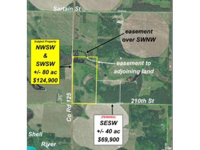
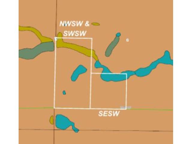
Approx 80 acres in great turkey-hunting country between the Shell River & the Straight River southwest of Park Rapids. Fairly level high ground w/ varying ages of red pine, oak, & aspen offset by a band of wetland in the north & wetland surrounded by a nice stand of oak in the center. County rd access along the west & twp rd access along the south. An easement over a trail thru adj property will provide access to the area north of the band of wetland.
Main Property Info
Property ID
W2SW130008010
W2SW130008010
MLS Number
4637468
4637468
Status
Sold
Sold
List Price
$124,900
$124,900
Selling Price
$115,700
$115,700
Acres
80.000
80.000
Zoning
Agricultural
Agricultural
City
Park Rapids
Park Rapids
Township
Green Valley Twp
Green Valley Twp
State
MN
MN
Zip Code
56470
56470
County
Becker
Becker
Legal Description
NWSW & SWSW, 2-139-36. Together with easement over SWNW. Subject to Co Rd 125; 210th St; easement to adjoining land; and any other easements, restrictions, or reservations of record.
NWSW & SWSW, 2-139-36. Together with easement over SWNW. Subject to Co Rd 125; 210th St; easement to adjoining land; and any other easements, restrictions, or reservations of record.
Property Location
Directions
From US Hwy 71 & Hubbard CR14 south of Park Rapids, west on Hubbard Co Rd 14 (which turns into Becker Co Rd 42) for 6 4/10 miles. Right (north) on Co Rd 125 for 1 mile to the southwest corner of the tract at the intersection of Co Rd 125 and 210th St.
From US Hwy 71 & Hubbard CR14 south of Park Rapids, west on Hubbard Co Rd 14 (which turns into Becker Co Rd 42) for 6 4/10 miles. Right (north) on Co Rd 125 for 1 mile to the southwest corner of the tract at the intersection of Co Rd 125 and 210th St.
Access
This property fronts unpaved Co Rd 125 on the west and unpaved township road 210th St on the south. There is also an easement over a trail through the adjoining property to the north (SWNW) to provide access to the portion of the tract north of the wetland area.
This property fronts unpaved Co Rd 125 on the west and unpaved township road 210th St on the south. There is also an easement over a trail through the adjoining property to the north (SWNW) to provide access to the portion of the tract north of the wetland area.
GPS Coordinates
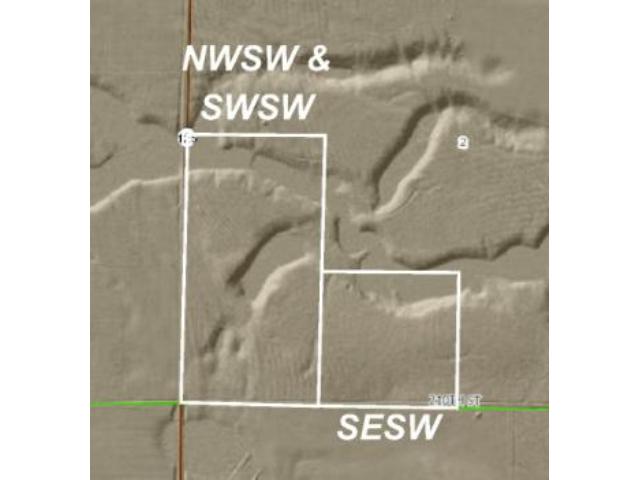
GPS coordinates to approximate corners and points based on county mapping: SW corner at the intersection of Co Rd 125 and 210th St = 46.8772, -95.2049; NW corner along Co Rd 125 = 46.8843, -95.2048; point where easement trail crosses north boundary = 46.8843, -95.2018; NE corner = 46.8843, -95.1995; SE corner along 210th St = 46.8771, -95.1996.
GPS coordinates to approximate corners and points based on county mapping: SW corner at the intersection of Co Rd 125 and 210th St = 46.8772, -95.2049; NW corner along Co Rd 125 = 46.8843, -95.2048; point where easement trail crosses north boundary = 46.8843, -95.2018; NE corner = 46.8843, -95.1995; SE corner along 210th St = 46.8771, -95.1996.
Address
W2SW County Road 125
W2SW County Road 125
School District
Park Rapids - 309
Park Rapids - 309
Property Details
Dimensions (approx)
2640x2640x1320x1320
2640x2640x1320x1320
Utilities
Available Utilities
Electric
Electric
On Site Utilities
None
None
Power Company
Itasca-Mantrap Co-op (1-888-713-3377)
Itasca-Mantrap Co-op (1-888-713-3377)
Taxes & Fees
Association Fee
$0
$0
Tax Amount
$962
$962
Tax With Assessments
$962
$962
Tax Year
2015
2015
Other Details
Section Number
2
2
Township Number
139
139
Range Number
36
36
Estimated Upland %
85
85
Estimated Wetland %
15
15
Additional Comments
Timber Comments
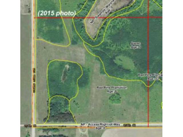
This property has been managed according to Forest Stewardship Council (FSC) standards. Timber includes red pine, oak, and aspen. If timber value is important to you, seek the advice of a competent forester to determine species, volumes and values. Inspect the property to ensure that it will meet your needs.
This property has been managed according to Forest Stewardship Council (FSC) standards. Timber includes red pine, oak, and aspen. If timber value is important to you, seek the advice of a competent forester to determine species, volumes and values. Inspect the property to ensure that it will meet your needs.
Hunting Comments
This property is near public land in MN firearms deer zone 241. Great combination of upland with varying timber and wetlands lined with oak for wildlife roaming and tree cover. Public Becker County Shipman Memorial Forest land is about 2 miles south and public Smokey Hills State Forest land is about 5 miles west for additional hunting.
This property is near public land in MN firearms deer zone 241. Great combination of upland with varying timber and wetlands lined with oak for wildlife roaming and tree cover. Public Becker County Shipman Memorial Forest land is about 2 miles south and public Smokey Hills State Forest land is about 5 miles west for additional hunting.
Disclosures
Parcel split; acreage, dimensions, and taxes estimated based on county data and mapping; county disclaimers included by reference. Not surveyed. Photos/maps for convenience only and not guaranteed; tree cover may be different than depicted; physically inspect prior to purchase. Any deer stands on the land are not property of seller and are not included in sale. Use seller-approved PA and addendum; closing dates 2nd Wed each month.
Parcel split; acreage, dimensions, and taxes estimated based on county data and mapping; county disclaimers included by reference. Not surveyed. Photos/maps for convenience only and not guaranteed; tree cover may be different than depicted; physically inspect prior to purchase. Any deer stands on the land are not property of seller and are not included in sale. Use seller-approved PA and addendum; closing dates 2nd Wed each month.
Additional Details
Parcel ID:
Pt of 130008011
Pt of 130008011


