

MLS Number : 4534119
Sold $45,500 - Hunting & Recreation
Rural 40 acres of Potlatch land w/in Lyons State Forest by the Crow Wing River north of Staples. Level topography and newly-planted red pine w/ wetland in the north. Near Knob Hill Campground, Cottingham Park, & Dry Sand Lake State Wildlife Mgmt Area.
Main Property Info
Property ID
030034010
030034010
MLS Number
4534119
4534119
Status
Sold
Sold
List Price
$49,900
$49,900
Selling Price
$45,500
$45,500
Acres
40.000
40.000
Zoning
A-2 Mixed Agriculture
A-2 Mixed Agriculture
City
Staples
Staples
Township
Bullard Twp
Bullard Twp
State
MN
MN
Zip Code
56479
56479
County
Wadena
Wadena
Legal Description
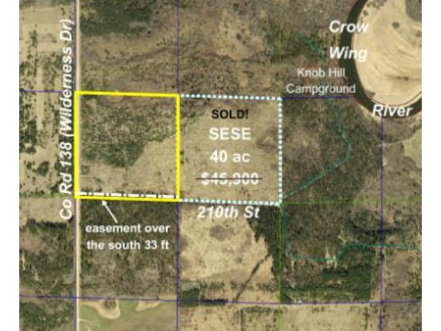
SWSE, 3-135-33. Subject to Co Rd 138 (Wilderness Dr) and 210th St (T-608). Subject to easement for ingress, egress, and utility purposes over, under, and across the south 33 feet providing access to SESE, 3-135-33. Subject to any easements, restrictions, or reservations of record.
SWSE, 3-135-33. Subject to Co Rd 138 (Wilderness Dr) and 210th St (T-608). Subject to easement for ingress, egress, and utility purposes over, under, and across the south 33 feet providing access to SESE, 3-135-33. Subject to any easements, restrictions, or reservations of record.
Property Location
Directions
From US Hwy 10 & 255th Ave/CR55/CR125 west of Staples, N on 255th Ave 2.1 mi. Left on CR2/CR30 for 0.5 mi. Right on CR29/251st Ave 4.6 mi. Right on CR29/CR138/Wilderness Dr for 5.4 mi to trl on right.
From US Hwy 10 & 255th Ave/CR55/CR125 west of Staples, N on 255th Ave 2.1 mi. Left on CR2/CR30 for 0.5 mi. Right on CR29/251st Ave 4.6 mi. Right on CR29/CR138/Wilderness Dr for 5.4 mi to trl on right.
Access
Access is via Co Rd 138 (Wilderness Dr) along the west boundary and 210th St (T-608) along the south boundary.
Access is via Co Rd 138 (Wilderness Dr) along the west boundary and 210th St (T-608) along the south boundary.
GPS Coordinates
Coordinates to approximate corners/points based on county mapping: Point where a trail off Co Rd 138 (Wilderness Dr) enters the west side of the property near the SW corner = 46.5287, -94.8318; SW corner at the intersection of Co Rd 138 (Wilderness Dr) and 210th St (T-608) = 46.5280, -94.8320; NW corner along Co Rd 138 (Wilderness Dr) = 46.5316, -94.8320; NE corner = 46.5315, -94.8267; SE corner along 210th St (T-608) = 46.5278, -94.8267
Coordinates to approximate corners/points based on county mapping: Point where a trail off Co Rd 138 (Wilderness Dr) enters the west side of the property near the SW corner = 46.5287, -94.8318; SW corner at the intersection of Co Rd 138 (Wilderness Dr) and 210th St (T-608) = 46.5280, -94.8320; NW corner along Co Rd 138 (Wilderness Dr) = 46.5316, -94.8320; NE corner = 46.5315, -94.8267; SE corner along 210th St (T-608) = 46.5278, -94.8267
Address
SWSE Wilderness Drive
SWSE Wilderness Drive
School District
Staples-Motley - 2170
Staples-Motley - 2170
Property Details
Dimensions (approx)
1320x1320x1320x1320
1320x1320x1320x1320
Utilities
Available Utilities
None
None
On Site Utilities
None
None
Power Company
Todd-Wadena Electric (1-800-320-8932)
Todd-Wadena Electric (1-800-320-8932)
Taxes & Fees
Association Fee
$0
$0
Tax Amount
$540
$540
Tax With Assessments
$540
$540
Tax Year
2016
2016
Other Details
Section Number
3
3
Township Number
135
135
Range Number
33
33
Estimated Upland %
95
95
Estimated Wetland %
5
5
Additional Comments
Timber Comments
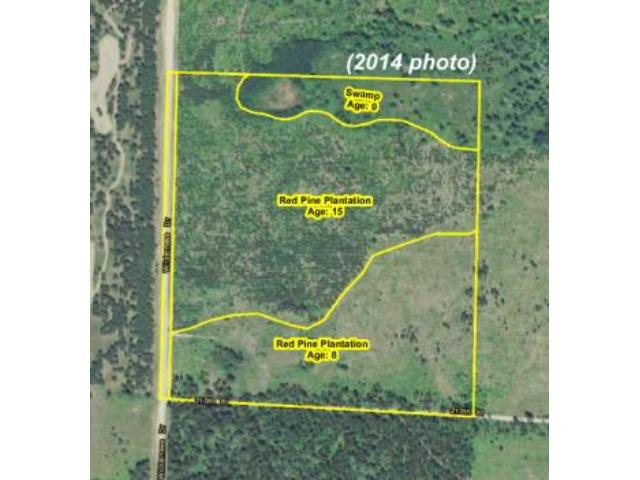
This property has been managed according to Forest Stewardship Council (FSC) standards. A portion of it has been harvested and replanted with Red Pine. If timber value is important to you, seek the advice of a competent forester to determine species, volumes and values.
This property has been managed according to Forest Stewardship Council (FSC) standards. A portion of it has been harvested and replanted with Red Pine. If timber value is important to you, seek the advice of a competent forester to determine species, volumes and values.
Hunting Comments
This is a remote-but-accessible tract that adjoins public land in MN firearms deer zone 246. The hundreds of acres of adjoining public state forestland and the Dry Sand Lake State Wildlife Management Area a few miles east of the river allows wildlife to flourish in this popular area for hunting whitetail deer, bear, waterfowl, and small game.
This is a remote-but-accessible tract that adjoins public land in MN firearms deer zone 246. The hundreds of acres of adjoining public state forestland and the Dry Sand Lake State Wildlife Management Area a few miles east of the river allows wildlife to flourish in this popular area for hunting whitetail deer, bear, waterfowl, and small game.
Disclosures
Subject to easement over the south 33 ft. Not surveyed; acreage and dimensions approximate based on county data and mapping; county disclaimers included by reference. Photos/maps for convenience only and not guaranteed; tree cover may be different than depicted; physically inspect prior to purchase. Any deer stands on the land are not property of seller and are not included in sale. Use seller-approved PA and addendum; closing dates the 2nd Wednesday each month.
Subject to easement over the south 33 ft. Not surveyed; acreage and dimensions approximate based on county data and mapping; county disclaimers included by reference. Photos/maps for convenience only and not guaranteed; tree cover may be different than depicted; physically inspect prior to purchase. Any deer stands on the land are not property of seller and are not included in sale. Use seller-approved PA and addendum; closing dates the 2nd Wednesday each month.


