


MLS Number : 4730083
Sold $25,900 - Hunting & Recreation
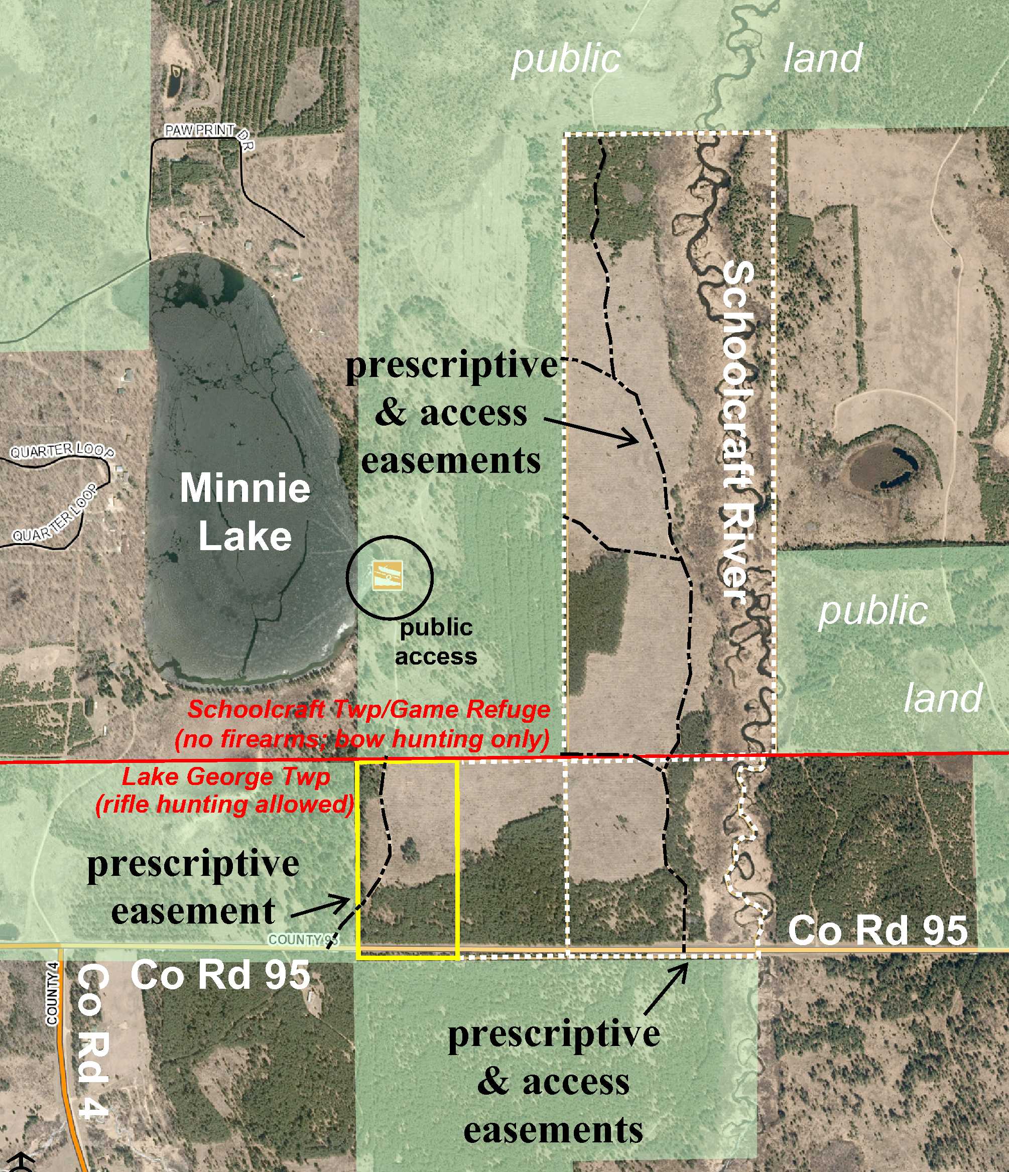
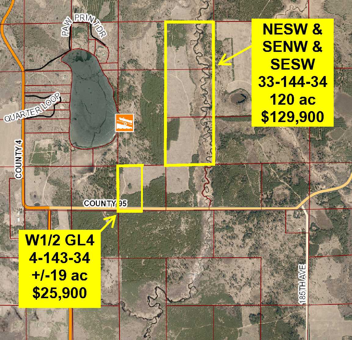
Potlatch land just off the shores of Lake Minnie and the Schoolcraft River northeast of Lake George. Tract has been surveyed. Sloped upland topography with red pine timber. Gravel county road along the south. An easement trail through public land adjoining the west connects to prescriptive easement trail through this tract, which leads to Minnie Lake public access. Public Paul Bunyan State Forest land adjoins the south and west. Minutes from Itasca State Park.
Main Property Info
Property ID
170400600
170400600
MLS Number
4730083
4730083
Status
Sold
Sold
List Price
$25,900
$25,900
Selling Price
$25,900
$25,900
Acres
18.99
18.99
Zoning
not zoned
not zoned
City
Lake George
Lake George
Township
Lake George Twp
Lake George Twp
State
MN
MN
Zip Code
56458
56458
County
Hubbard
Hubbard
Legal Description
W1/2GL4, 4-143-34. Subject to Co Rd 95; prescriptive easement over existing trail; and any other easements, restrictions, or reservations of record.
W1/2GL4, 4-143-34. Subject to Co Rd 95; prescriptive easement over existing trail; and any other easements, restrictions, or reservations of record.
Property Location
Directions
For viewing: From the intersection of US Hwy 71/State Hwy 200 & CR 4 in Lake George, east on US Hwy 71/State Hwy 200 for 1/2 mile. Left on CR 68 (185th Ave) for 2 miles. Left on CR 95 for 9/10 mile. Right on trail through public land approx 285 ft into west side of the tract. Easement trail continues northerly through west portion of tract. (ALTERNATE DIRECTIONS: From the intersection of US Hwy 71/State Hwy 200 and Co Rd 4 in Lake George, north then west then north on Co Rd 4 for 3 2/10 miles. Right on Co Rd 95 for 1/2 mile. Right on trail through public land approx 285 ft into west side of the tract. Easement trail continues northerly through west portion of tract.)
For viewing: From the intersection of US Hwy 71/State Hwy 200 & CR 4 in Lake George, east on US Hwy 71/State Hwy 200 for 1/2 mile. Left on CR 68 (185th Ave) for 2 miles. Left on CR 95 for 9/10 mile. Right on trail through public land approx 285 ft into west side of the tract. Easement trail continues northerly through west portion of tract. (ALTERNATE DIRECTIONS: From the intersection of US Hwy 71/State Hwy 200 and Co Rd 4 in Lake George, north then west then north on Co Rd 4 for 3 2/10 miles. Right on Co Rd 95 for 1/2 mile. Right on trail through public land approx 285 ft into west side of the tract. Easement trail continues northerly through west portion of tract.)
Access
Gravel Co Rd 95 is along the south. An easement trail through public land to the west connects to prescriptive easement trail through this tract.
Gravel Co Rd 95 is along the south. An easement trail through public land to the west connects to prescriptive easement trail through this tract.
GPS Coordinates
Coordinates to approximate corners/points based on county mapping: Point where prescriptive easement trail enters west side of tract = 47.2370, -95.0051; SW corner along Co Rd 95 = 47.2361, -95.0051; NW corner = 47.2395, -95.0052; point where prescriptive easement trail exits north boundary = 47.2395, -95.0045; NE corner = 47.2396, -95.0024; SE corner along Co Rd 95 = 47.2361, -95.0024.
Coordinates to approximate corners/points based on county mapping: Point where prescriptive easement trail enters west side of tract = 47.2370, -95.0051; SW corner along Co Rd 95 = 47.2361, -95.0051; NW corner = 47.2395, -95.0052; point where prescriptive easement trail exits north boundary = 47.2395, -95.0045; NE corner = 47.2396, -95.0024; SE corner along Co Rd 95 = 47.2361, -95.0024.
Address
County Road 95
County Road 95
School District
Laporte - 306
Laporte - 306
Property Details
Dimensions (approx)
673 x 1273 x 674 x 1292
673 x 1273 x 674 x 1292
Utilities
Power Company
Itasca-Mantrap Co-op (1-888-713-3377)
Itasca-Mantrap Co-op (1-888-713-3377)
Taxes & Fees
Tax Amount
$311
$311
Tax With Assessments
$311
$311
Assessment Pending
No
No
Tax Year
2016
2016
Other Details
Section Number
4
4
Township Number
143
143
Range Number
34
34
Estimated Upland %
99
99
Estimated Wetland %
1
1
Additional Comments
Timber Comments
This property has been managed according to Forest Stewardship Council (FSC) standards. It is wooded with red pine. If timber value is important to you, seek the advice of a competent forester to determine species, volumes and values.
This property has been managed according to Forest Stewardship Council (FSC) standards. It is wooded with red pine. If timber value is important to you, seek the advice of a competent forester to determine species, volumes and values.
Hunting Comments
This property adjoins public land in MN Firearms Deer Zone 184.
This property adjoins public land in MN Firearms Deer Zone 184.
Disclosures
Parcel split; taxes estimated; subject to split approval. See survey for exact dimensions; survey indicates approx 19.85 acres whereas half of county parcel info for parent parcel would be 18.99 acres. County disclaimers included by reference. Photos/maps for convenience only and not guaranteed; tree cover may be different than depicted; physically inspect prior to purchase. Any deer stands on the land are not property of seller and are not included in sale. Use seller-approved PA and addendum; closing dates the 2nd Wednesday each month.
Parcel split; taxes estimated; subject to split approval. See survey for exact dimensions; survey indicates approx 19.85 acres whereas half of county parcel info for parent parcel would be 18.99 acres. County disclaimers included by reference. Photos/maps for convenience only and not guaranteed; tree cover may be different than depicted; physically inspect prior to purchase. Any deer stands on the land are not property of seller and are not included in sale. Use seller-approved PA and addendum; closing dates the 2nd Wednesday each month.


