

MLS Number : 4642859
Sold $45,800 - Hunting & Recreation
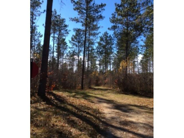
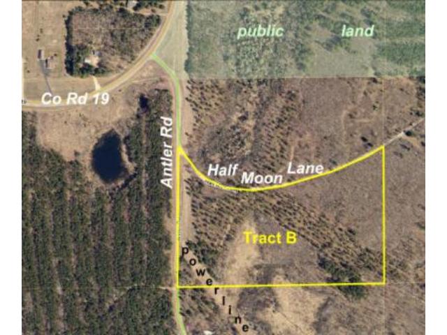
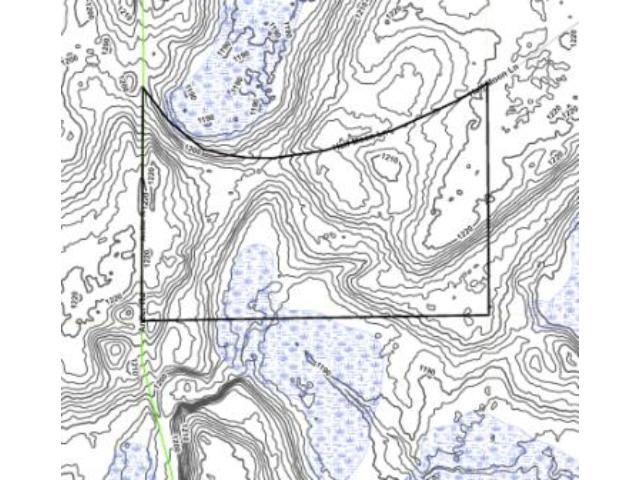
Newly-offered tract of Potlatch land near Fawn Lake & the Mississippi River north of Merrifield. Approx 21 acres of rolling land with a small wetland on the south side. Good township road access along west boundary, and Half Moon Ln along the north boundary leads to public access to the river. Public access to Fawn Lake is about a mile south. Trails meandering throughout tract. Open power line in SW corner offers great shooting lanes for hunting. Lots of public land close by for add’l hunting.
Main Property Info
Property ID
TBD, Pt of 520212200000009
TBD, Pt of 520212200000009
MLS Number
4642859
4642859
Status
Sold
Sold
List Price
$51,500
$51,500
Selling Price
$45,800
$45,800
Acres
21.000
21.000
Zoning
Rural Residential 10
Rural Residential 10
City
Merrifield
Merrifield
Township
Center Twp
Center Twp
State
MN
MN
Zip Code
56465
56465
County
Crow Wing
Crow Wing
Legal Description
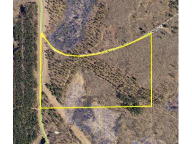
"Tract B" - Part of NWNW lying south of the centerline of Half Moon Ln, 21-135-27. Subject to Antler Rd, Half Moon Ln, DNR prescriptive easement, easements in Doc# 378884 & 512214, power line, and any other easements, restrictions, or reservations of record.
"Tract B" - Part of NWNW lying south of the centerline of Half Moon Ln, 21-135-27. Subject to Antler Rd, Half Moon Ln, DNR prescriptive easement, easements in Doc# 378884 & 512214, power line, and any other easements, restrictions, or reservations of record.
Property Location
Directions
From the intersection of Co Rd 3 and Co Rd 4 north of Merrifield, east/northeast on Co Rd 3 for 2 miles. Right on Co Rd 19 for 2 1/10 miles. Right on Antler Rd approx 400 ft to NW corner of the property at the intersection of Antler Rd and Half Moon Ln.
From the intersection of Co Rd 3 and Co Rd 4 north of Merrifield, east/northeast on Co Rd 3 for 2 miles. Right on Co Rd 19 for 2 1/10 miles. Right on Antler Rd approx 400 ft to NW corner of the property at the intersection of Antler Rd and Half Moon Ln.
Access
Antler Rd (an unpaved township road) runs along the west boundary of the property and unpaved Half Moon Ln runs along the north boundary.
Antler Rd (an unpaved township road) runs along the west boundary of the property and unpaved Half Moon Ln runs along the north boundary.
GPS Coordinates
GPS coordinates to approximate corners and points based on county mapping: NW corner at the intersection of Antler Rd and Half Moon Ln = 46.4993, -94.0995; NE corner along Half Moon Ln = 46.4993, -94.0943; SE corner = 46.4969, -94.0943; SW corner along Antler Rd = 46.4968, -94.0996
GPS coordinates to approximate corners and points based on county mapping: NW corner at the intersection of Antler Rd and Half Moon Ln = 46.4993, -94.0995; NE corner along Half Moon Ln = 46.4993, -94.0943; SE corner = 46.4969, -94.0943; SW corner along Antler Rd = 46.4968, -94.0996
Address
TractB Antler Road
TractB Antler Road
School District
Brainerd - 181
Brainerd - 181
Property Details
Dimensions (approx)
883x879x2173x1320
883x879x2173x1320
Utilities
Available Utilities
Electric
Electric
On Site Utilities
None
None
Power Company
Crow Wing Power (1-800-648-9401)
Crow Wing Power (1-800-648-9401)
Taxes & Fees
Association Fee
$0
$0
Tax Amount
$234
$234
Tax With Assessments
$234
$234
Tax Year
2015
2015
Other Details
Section Number
21
21
Township Number
135
135
Range Number
27
27
Estimated Upland %
95
95
Estimated Wetland %
5
5
Additional Comments
Timber Comments
This property has been managed according to Forest Stewardship Council (FSC) standards. Timber includes aspen and red pine. If timber value is important to you, seek the advice of a competent forester to determine species, volumes and values.
This property has been managed according to Forest Stewardship Council (FSC) standards. Timber includes aspen and red pine. If timber value is important to you, seek the advice of a competent forester to determine species, volumes and values.
Hunting Comments
This property is near public land in MN firearms deer zone 247. Over 250 acres of public land with Mississippi River frontage at the Co Rd 19/Antler Rd intersection and more public land within two miles provides lots of additional hunting space. This is a woodsy area saturated with lakes, river, and streams for abundant wildlife.
This property is near public land in MN firearms deer zone 247. Over 250 acres of public land with Mississippi River frontage at the Co Rd 19/Antler Rd intersection and more public land within two miles provides lots of additional hunting space. This is a woodsy area saturated with lakes, river, and streams for abundant wildlife.
Disclosures
Subject to Antler Rd, Half Moon Ln, DNR prescriptive easement, easements in Doc# 378884 & 512214, power line, and any other easements, restrictions, or reservations of record. Parcel split; acreage, dimensions, and taxes estimated based on county data and mapping; county disclaimers included by reference; subject to split approval. Not surveyed. Photos/maps for convenience only and not guaranteed; tree cover may be different than depicted; physically inspect prior to purchase. Any deer stands on the land are not property of seller and are not included in sale. Use seller-approved PA and addendum; closing dates the 2nd Wednesday each month.
Subject to Antler Rd, Half Moon Ln, DNR prescriptive easement, easements in Doc# 378884 & 512214, power line, and any other easements, restrictions, or reservations of record. Parcel split; acreage, dimensions, and taxes estimated based on county data and mapping; county disclaimers included by reference; subject to split approval. Not surveyed. Photos/maps for convenience only and not guaranteed; tree cover may be different than depicted; physically inspect prior to purchase. Any deer stands on the land are not property of seller and are not included in sale. Use seller-approved PA and addendum; closing dates the 2nd Wednesday each month.


