
MLS Number : 5011039
Sold $41,000 - Hunting & Recreation
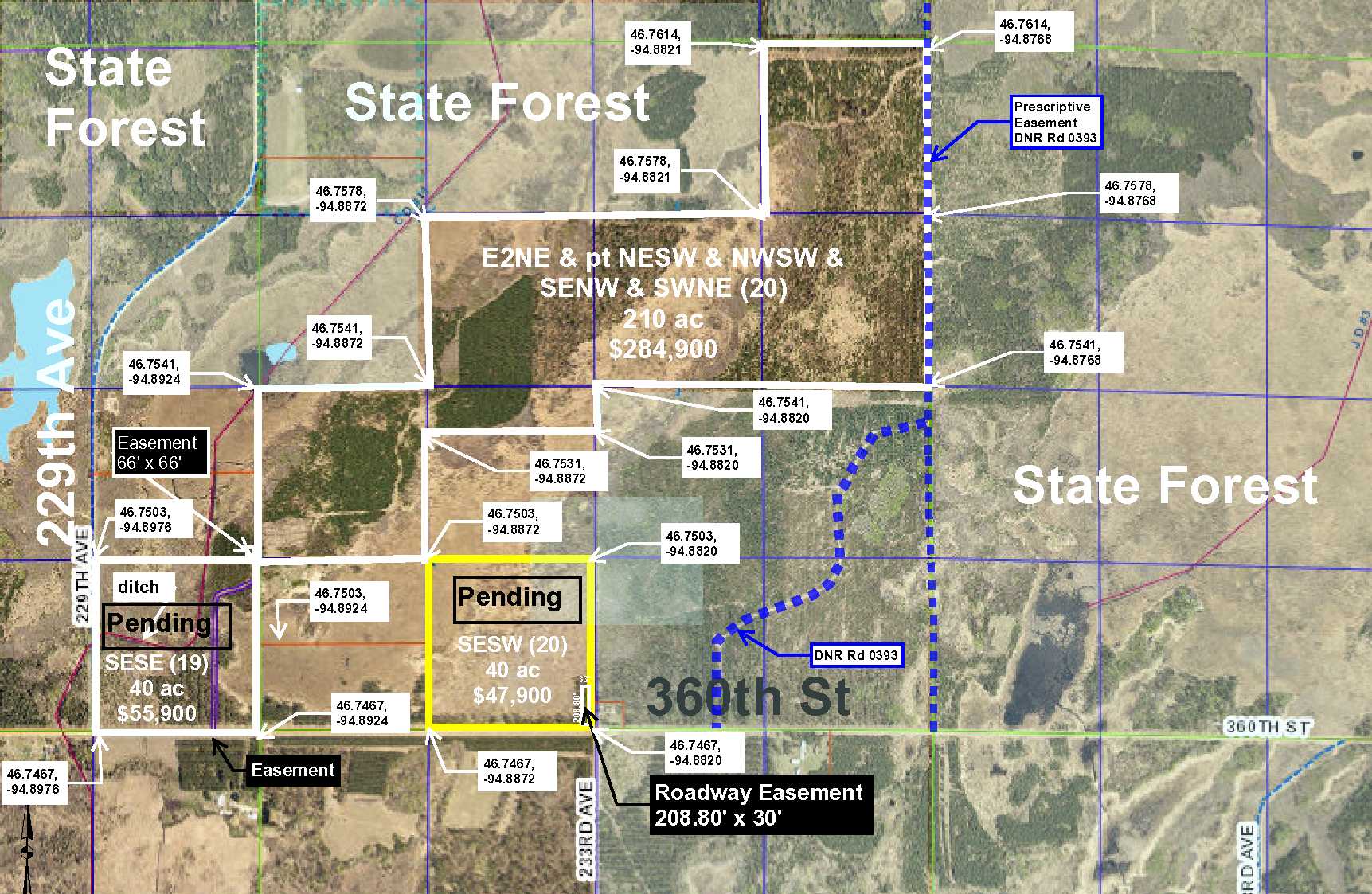
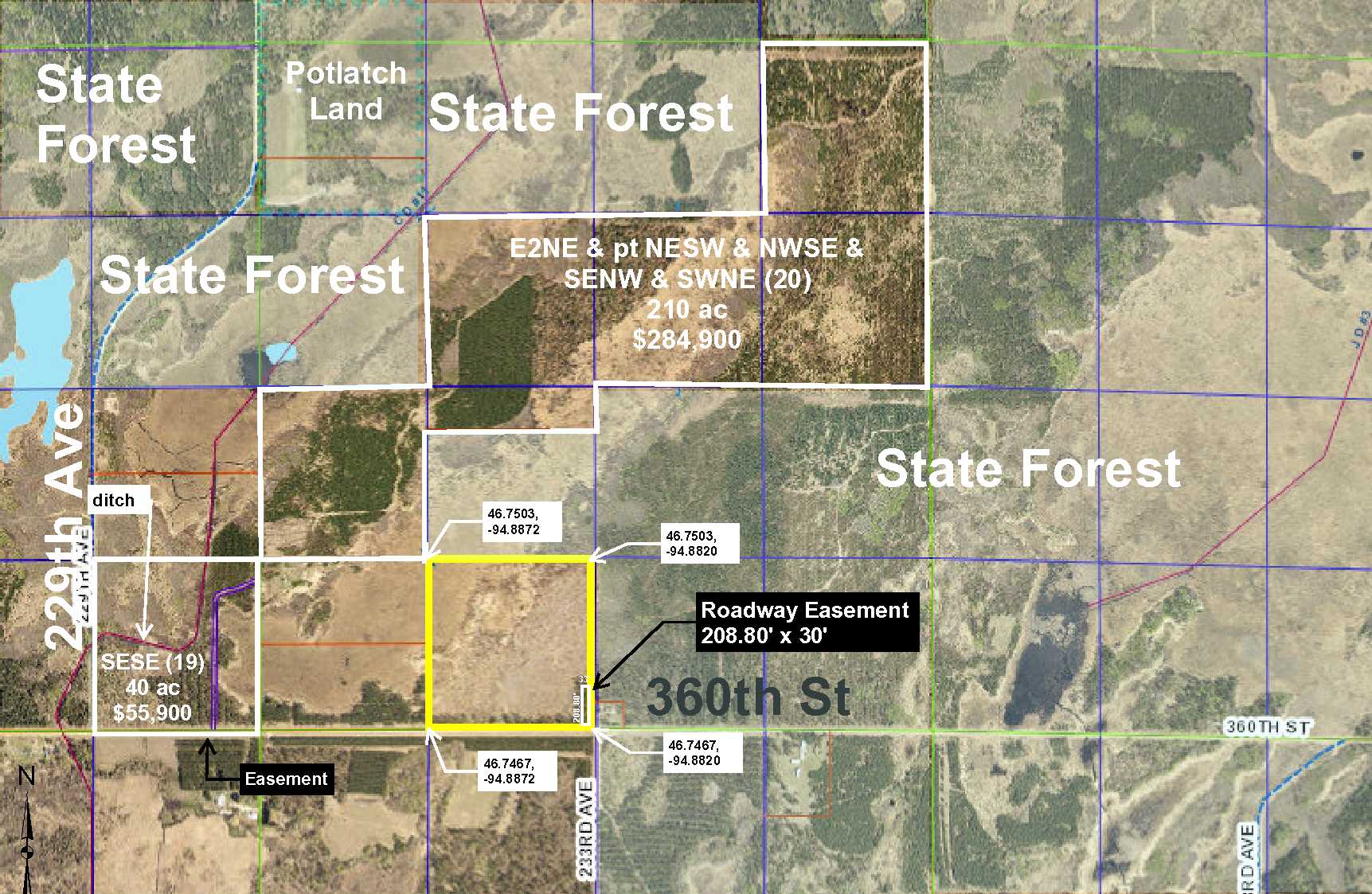
PotlatchDeltic property located on 360th St. near Sebeka, Menahga, and Huntersville in Wadena County. This area is known for great hunting, recreation, and country living. To the north and east, the property adjoins public land and Huntersville State Forest is only 3 miles away. OHV & snowmobile trails are readily available & the Outpost is close by for food & beverages. Also available, 2 neighboring properties, MLS #’s 5011004 & 5011050.
Main Property Info
Property ID
pt R040203020
pt R040203020
MLS Number
5011039
5011039
Status
Sold
Sold
List Price
$47,900
$47,900
Selling Price
$41,000
$41,000
Acres
40
40
Zoning
Agricultural, A2
Agricultural, A2
City
Menahga
Menahga
Township
Huntersville Twp
Huntersville Twp
State
MN
MN
Zip Code
56465
56465
County
Wadena
Wadena
Legal Description
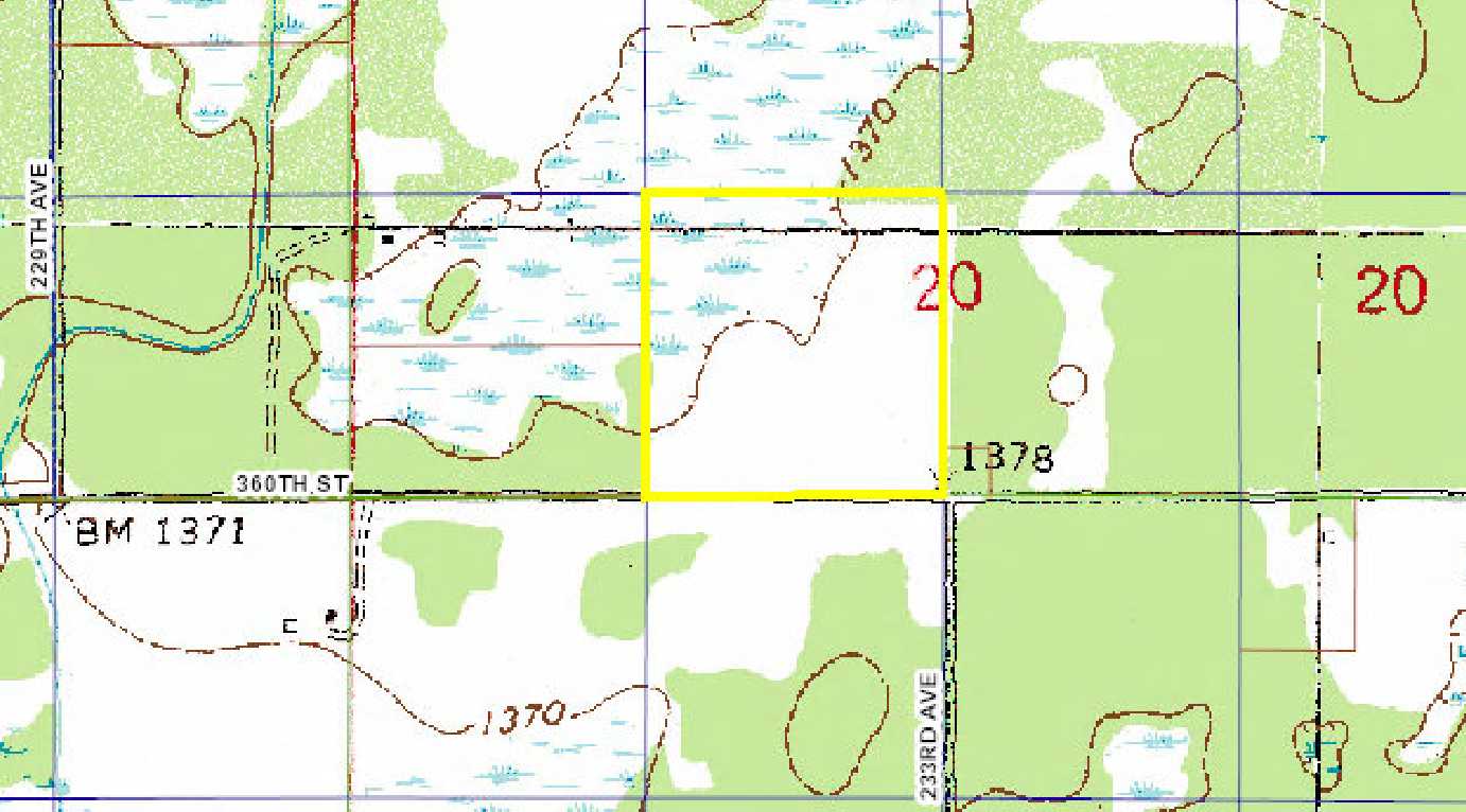
SESW, 20-138-33, Subject to easement Doc No. 250620, Subject to 360th St, subject to any easements, restrictions, or reservations of record.
SESW, 20-138-33, Subject to easement Doc No. 250620, Subject to 360th St, subject to any easements, restrictions, or reservations of record.
Property Location
Directions
In Sebeka at the intersection of Hwy 71 and Co Rd 12(East Minnesota Ave), head east to Nimrod, 9.5 miles, turn north onto Co Hwy 18 (Huntersville Rd) for 10.6 miles, west onto 360th St. for 1.6 miles to property on the north side of the road. From Menagha at the intersection of Hwy 71 and Co Rd 31 (Birch Ave SE), east 3.75 miles to Co Rd 23, turn south for 1.5 miles, turn east on 340th St for 5 miles, turn north on 219th Ave for 2 miles, turn east on 360th St. for 1.25 miles to the SE corner of the property.
In Sebeka at the intersection of Hwy 71 and Co Rd 12(East Minnesota Ave), head east to Nimrod, 9.5 miles, turn north onto Co Hwy 18 (Huntersville Rd) for 10.6 miles, west onto 360th St. for 1.6 miles to property on the north side of the road. From Menagha at the intersection of Hwy 71 and Co Rd 31 (Birch Ave SE), east 3.75 miles to Co Rd 23, turn south for 1.5 miles, turn east on 340th St for 5 miles, turn north on 219th Ave for 2 miles, turn east on 360th St. for 1.25 miles to the SE corner of the property.
Access
Access off of 360th St onto a driveway in the center of the property.
Access off of 360th St onto a driveway in the center of the property.
GPS Coordinates
Coordinates to approximate corners/points based on county mapping: SW corner = 46.7467, -94.8872; NW corner = 46.75039, -94.8872; NE corner = 46.75039, -95.8820; SE corner = 46.7467; -95.8820.
Coordinates to approximate corners/points based on county mapping: SW corner = 46.7467, -94.8872; NW corner = 46.75039, -94.8872; NE corner = 46.75039, -95.8820; SE corner = 46.7467; -95.8820.
Address
TBD 360th St
TBD 360th St
School District
Menahga - 821
Menahga - 821
Property Details
Dimensions (approx)
1320 x 1320 x 1320 x 1320
1320 x 1320 x 1320 x 1320
Utilities
Power Company
Todd-Wadena Electric (1-800-320-8932)
Todd-Wadena Electric (1-800-320-8932)
Taxes & Fees
Tax Amount
$542
$542
Assessment Amount
0
0
Tax With Assessments
$542
$542
Tax Year
2018
2018
Other Details
Section Number
20
20
Township Number
138
138
Range Number
33
33
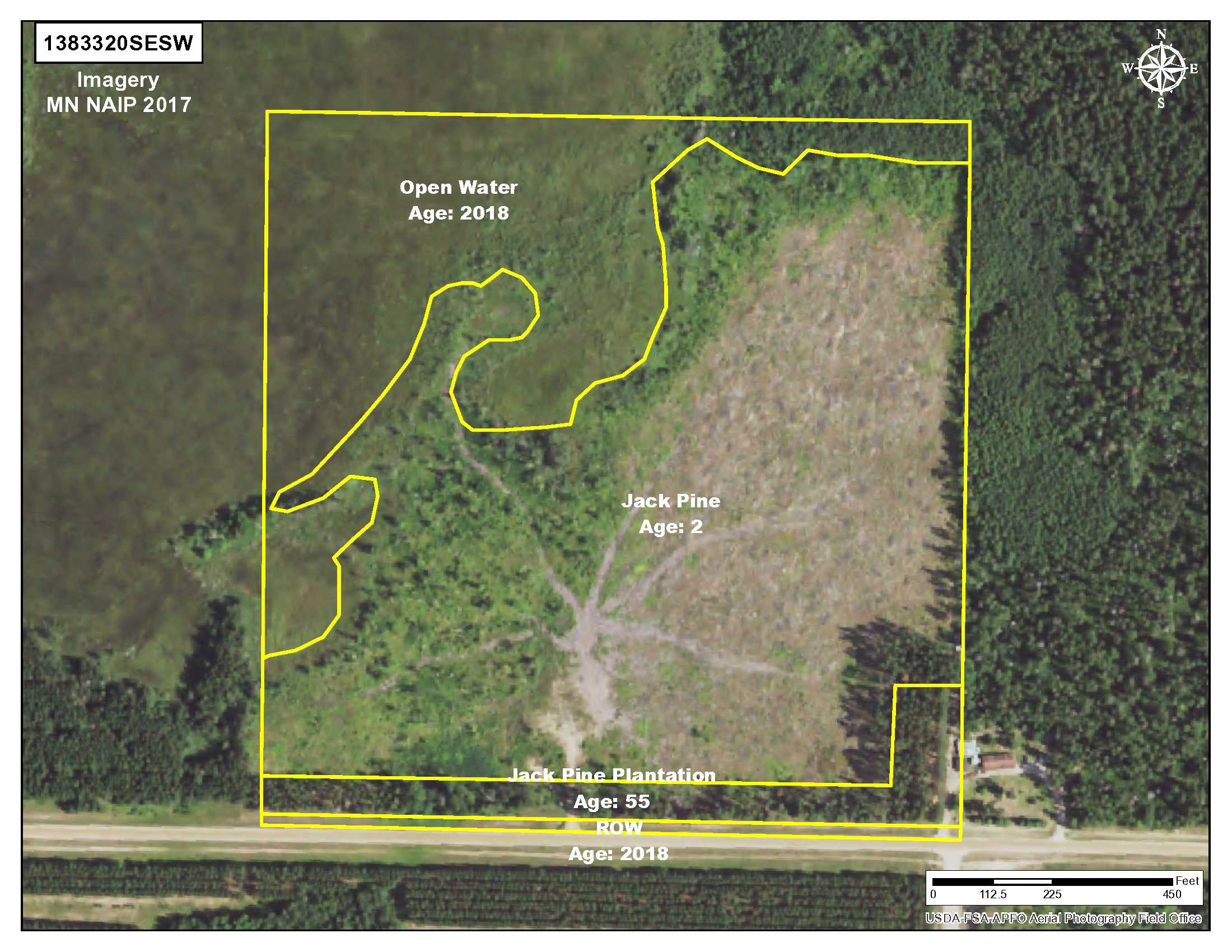
Estimated Upland %
75
75
Estimated Wetland %
25
25
Additional Comments
Timber Comments
This property has been managed according to Forest Stewardship Council (FSC) standards. If timber value is important to you, seek the advice of a competent forester to determine species, volumes, and values. Property includes 2-year jack pine.
This property has been managed according to Forest Stewardship Council (FSC) standards. If timber value is important to you, seek the advice of a competent forester to determine species, volumes, and values. Property includes 2-year jack pine.
Hunting Comments
This property adjoins public land in MN Firearms Zone 241.
This property adjoins public land in MN Firearms Zone 241.
Disclosures
Subject to easement document #250620, subject to 360th St. Not surveyed; acreage and dimensions approximate based on county data and mapping; county disclaimers included by reference. Photos/maps for convenience only and not guaranteed; physically inspect prior to purchase. Any deer stands on the land are not property of seller and are not included in sale. Use seller-approved PA and addendum; closing dates the 3rd Wednesday each month.
Subject to easement document #250620, subject to 360th St. Not surveyed; acreage and dimensions approximate based on county data and mapping; county disclaimers included by reference. Photos/maps for convenience only and not guaranteed; physically inspect prior to purchase. Any deer stands on the land are not property of seller and are not included in sale. Use seller-approved PA and addendum; closing dates the 3rd Wednesday each month.


