


MLS Number : 4833058
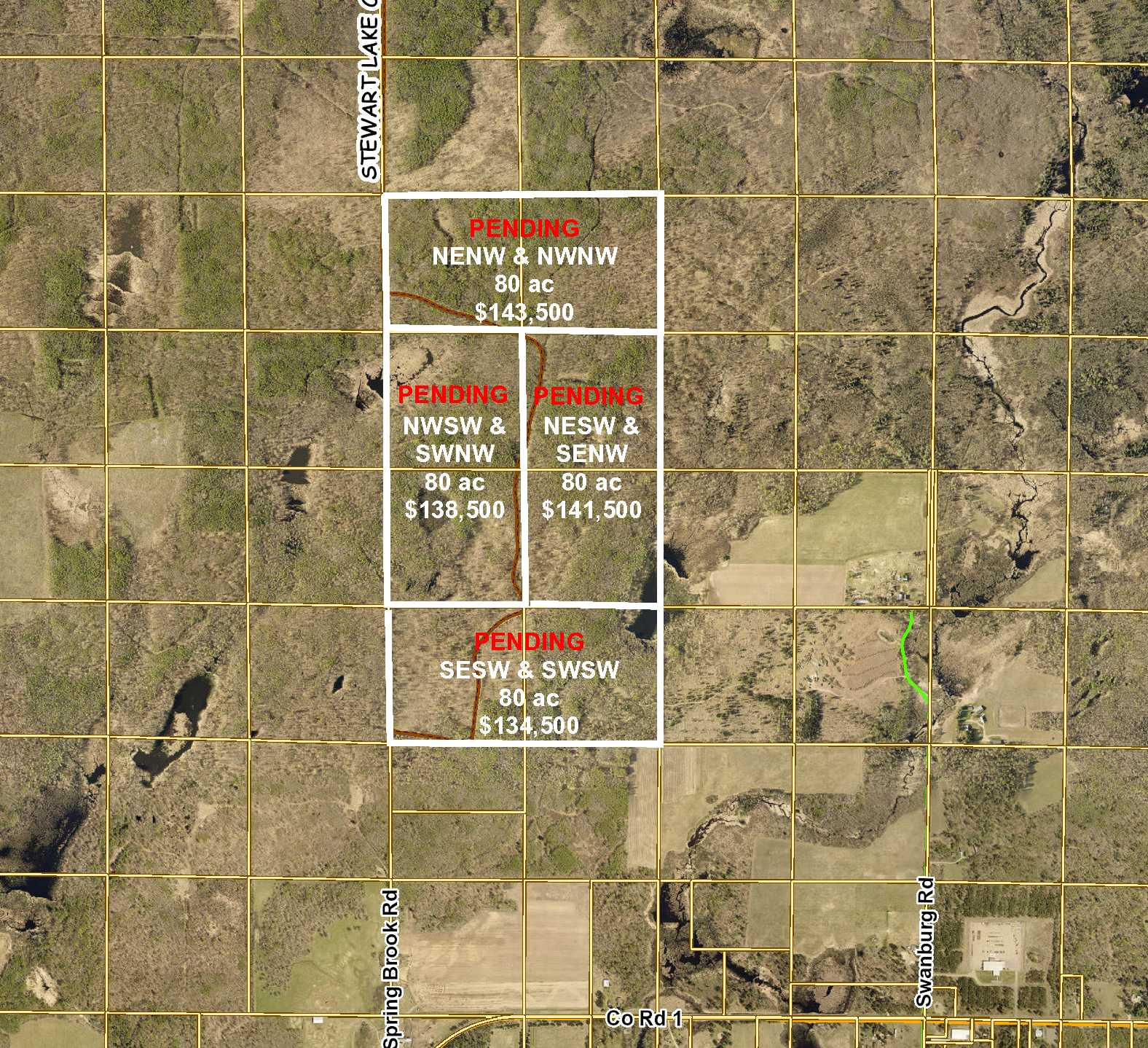
Sold $138,500 - Hunting & Recreation
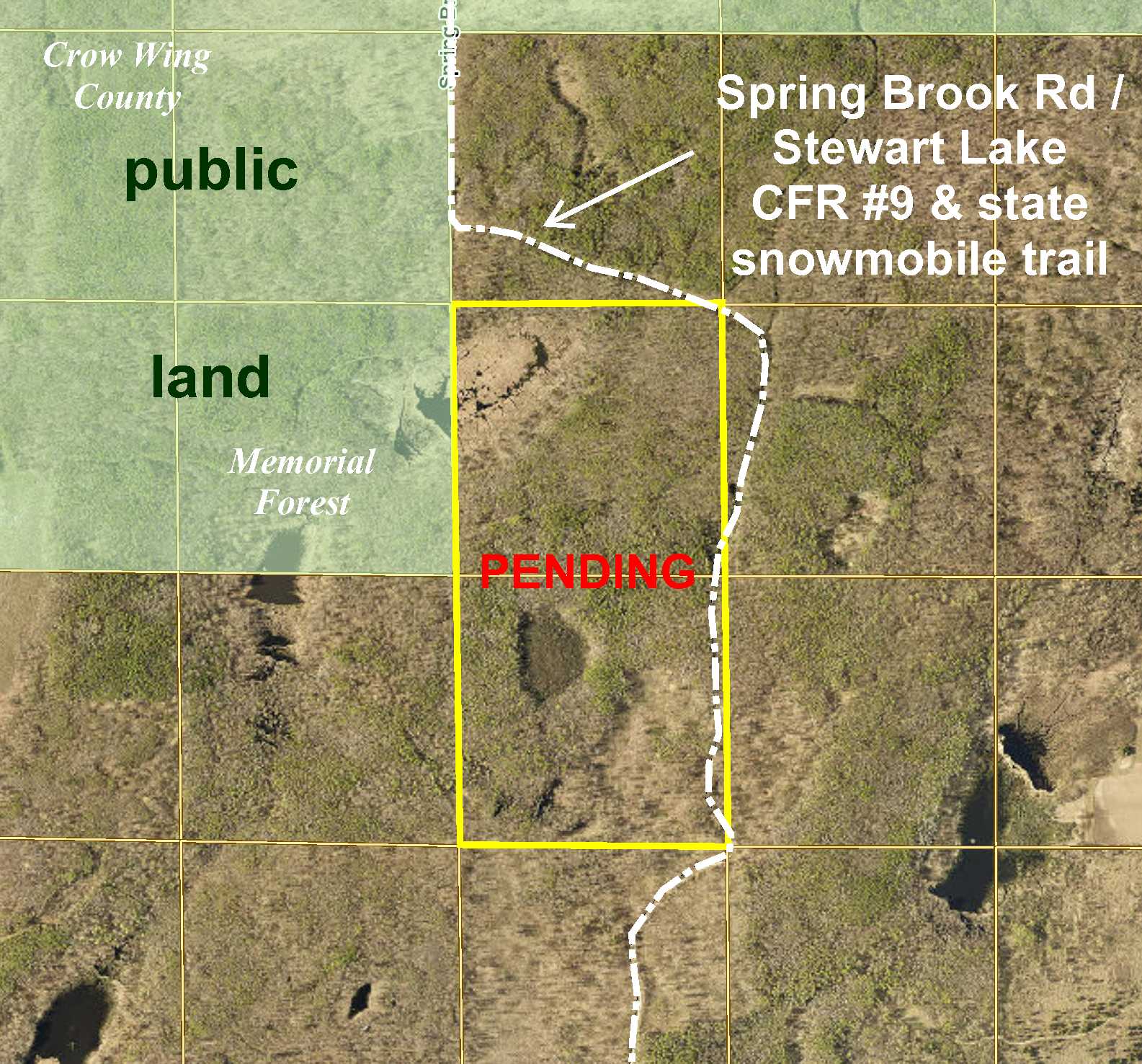
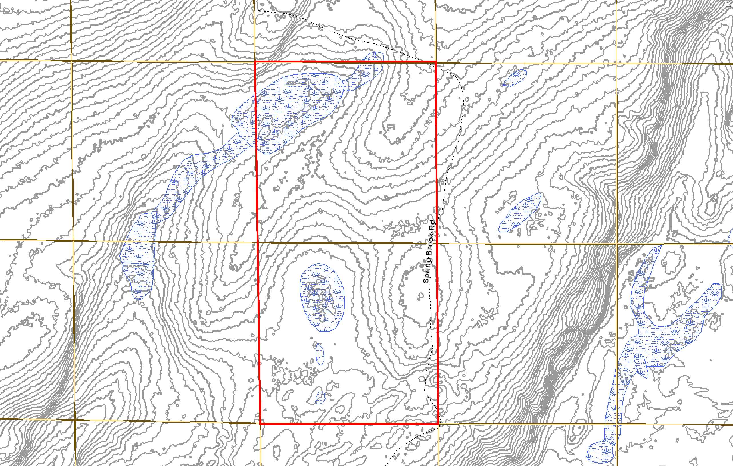
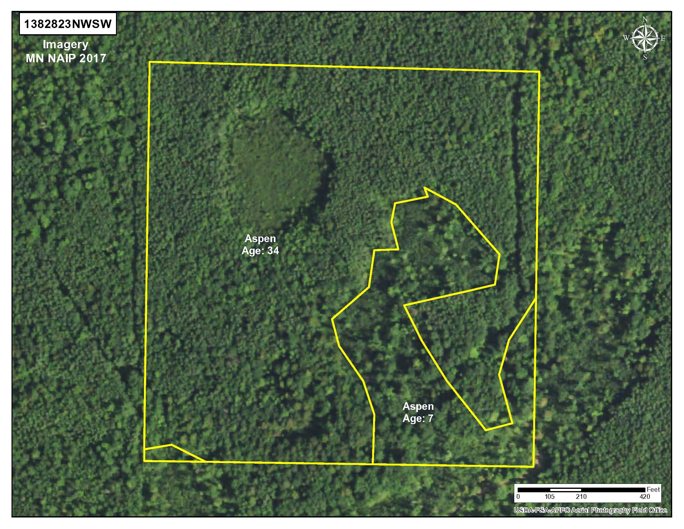
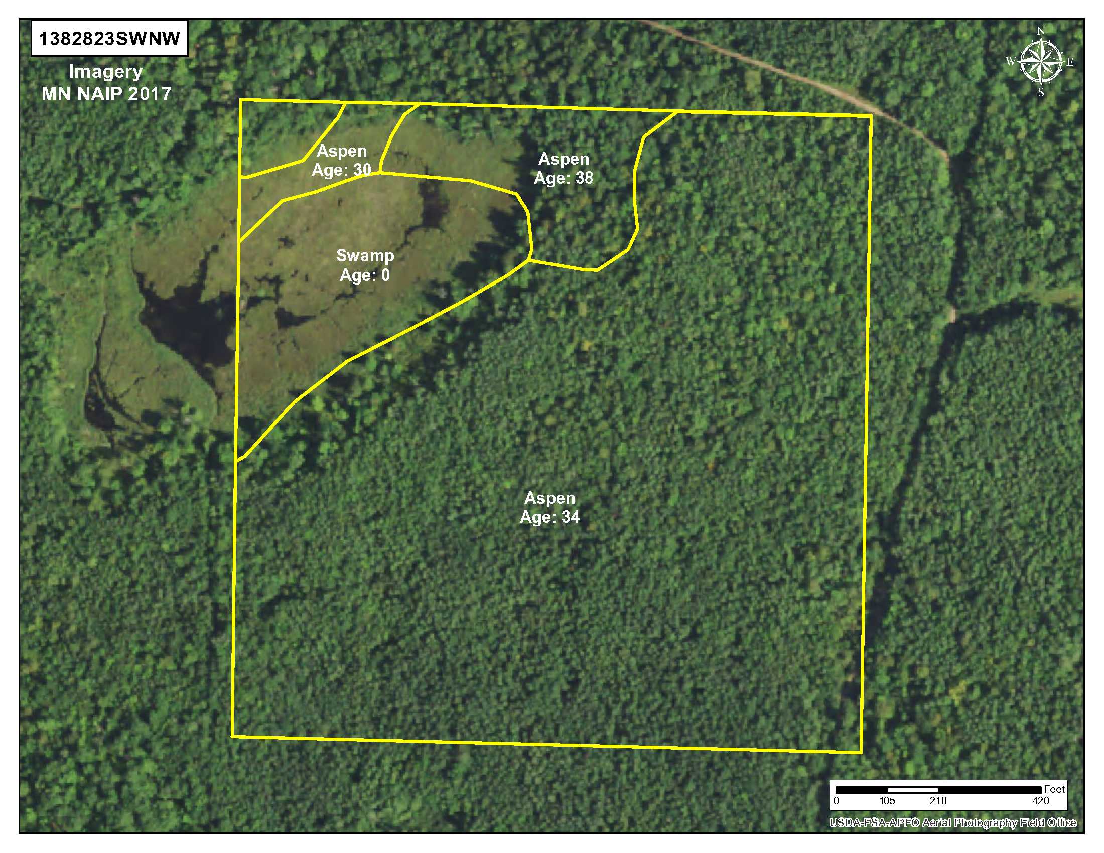
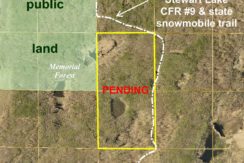
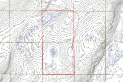
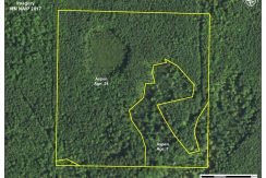
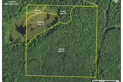
Price reduced from $153,900 to $138,500! Potlatch land near the beautiful Whitefish Chain east of Pine River. Gently-rolling upland with large wetland area in the northwest corner and smaller wetland area in the south half. Wooded with varying ages of aspen. Access is via a minimum maintenance road which runs along a portion of the east side. State snowmobile trail traverses along the road. Thousands of acres of public Crow Wing County Memorial Forest land adjoin a portion of the west side for expansive hunting space. Spring, summer, fall, or winter–this truly is land that can be enjoyed all seasons!
Main Property Info
Property ID
920232300000009 & 920233200000009
920232300000009 & 920233200000009
MLS Number
4833058
4833058
Status
Sold
Sold
List Price
$138,500
$138,500
Acres
80
80
Zoning
Agricultural/Forestry
Agricultural/Forestry
City
Pine River
Pine River
Township
Timothy Twp
Timothy Twp
State
MN
MN
Zip Code
56474
56474
County
Crow Wing
Crow Wing
Legal Description
NWSW & SWNW, 23-138-28. Subject to Spring Brook Rd, Stewart Lake CFR #9 (prescriptive easement), snowmobile trail, and any other easements, restrictions, or reservations of record.
NWSW & SWNW, 23-138-28. Subject to Spring Brook Rd, Stewart Lake CFR #9 (prescriptive easement), snowmobile trail, and any other easements, restrictions, or reservations of record.
Property Location
Directions
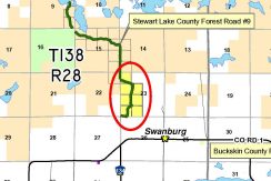
From the intersection of State Hwy 371 and Co Rd 15 in Jenkins, northeasterly on Co Rd 15 for 6 8/10 miles. Right on Co Rd 1 for 5 3/10 miles. Left on Spring Brook Rd (which curves east and also becomes Stewart Lake CFR #9) for 8/10 mile. Left on Spring Brook Rd/Stewart Lake CFR #9 approx 3/10 mile into SE corner of the property.
From the intersection of State Hwy 371 and Co Rd 15 in Jenkins, northeasterly on Co Rd 15 for 6 8/10 miles. Right on Co Rd 1 for 5 3/10 miles. Left on Spring Brook Rd (which curves east and also becomes Stewart Lake CFR #9) for 8/10 mile. Left on Spring Brook Rd/Stewart Lake CFR #9 approx 3/10 mile into SE corner of the property.
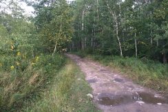
Access
Spring Brook Rd/Stewart Lake CFR #9 enters near the SE corner of the property and traverses along a portion of the east line. The road is a public township road but is minimum maintenance and rocky; a four-wheel drive vehicle is necessary for traveling. Buyer should ensure the access meets their needs.
Spring Brook Rd/Stewart Lake CFR #9 enters near the SE corner of the property and traverses along a portion of the east line. The road is a public township road but is minimum maintenance and rocky; a four-wheel drive vehicle is necessary for traveling. Buyer should ensure the access meets their needs.
GPS Coordinates
Coordinates to approximate corners/points based on county mapping: SE corner near where Spring Brook Rd/Stewart Lake CFR #9 enters the property = 46.7511, -94.1906; SW corner = 46.7511, -94.1958; NW corner = 46.7584, -94.1959; NE corner = 46.7583, -94.1906.
Coordinates to approximate corners/points based on county mapping: SE corner near where Spring Brook Rd/Stewart Lake CFR #9 enters the property = 46.7511, -94.1906; SW corner = 46.7511, -94.1958; NW corner = 46.7584, -94.1959; NE corner = 46.7583, -94.1906.
Address
Spring Brook Rd & Stewart Lake CFR #9
Spring Brook Rd & Stewart Lake CFR #9
School District
Pine River-Backus - 2174
Pine River-Backus - 2174
Property Details
Dimensions (approx)
1320 x 2640 x 1320 x 2640
1320 x 2640 x 1320 x 2640
Utilities
Power Company
Crow Wing Power (1-800-648-9401)
Crow Wing Power (1-800-648-9401)
Taxes & Fees
Tax Amount
$600
$600
Tax Year
2018
2018
Other Details
Section Number
23
23
Township Number
138
138
Range Number
28
28
Estimated Upland %
90
90
Estimated Wetland %
10
10
Additional Comments
Timber Comments
This property has been managed according to Forest Stewardship Council (FSC) standards and is wooded with varying ages of aspen. If timber value is important to you, seek the advice of a competent forester to determine species, volumes and values.
This property has been managed according to Forest Stewardship Council (FSC) standards and is wooded with varying ages of aspen. If timber value is important to you, seek the advice of a competent forester to determine species, volumes and values.
Hunting Comments
This property adjoins public land in MN Firearms Deer Zone 172. Thousands of acres of public Crow Wing County Memorial Forest land adjoin portion of the west side for expansive hunting space.
This property adjoins public land in MN Firearms Deer Zone 172. Thousands of acres of public Crow Wing County Memorial Forest land adjoin portion of the west side for expansive hunting space.
Disclosures
Spring Brook Rd/Stewart Lake CFR #9 is a public township road but is minimum maintenance; buyer should ensure that the access meets their needs. Not surveyed; acreage and dimensions approximate based on county data and mapping; county disclaimers included by reference. Photos/maps for convenience only and not guaranteed; physically inspect prior to purchase. Any deer stands on the land are not property of seller and are not included in sale. Use seller-approved PA and addendum; closing dates the 3rd Wednesday each month.
Spring Brook Rd/Stewart Lake CFR #9 is a public township road but is minimum maintenance; buyer should ensure that the access meets their needs. Not surveyed; acreage and dimensions approximate based on county data and mapping; county disclaimers included by reference. Photos/maps for convenience only and not guaranteed; physically inspect prior to purchase. Any deer stands on the land are not property of seller and are not included in sale. Use seller-approved PA and addendum; closing dates the 3rd Wednesday each month.


