
MLS Number : 4919110
Sold $98,400 - Hunting & Recreation
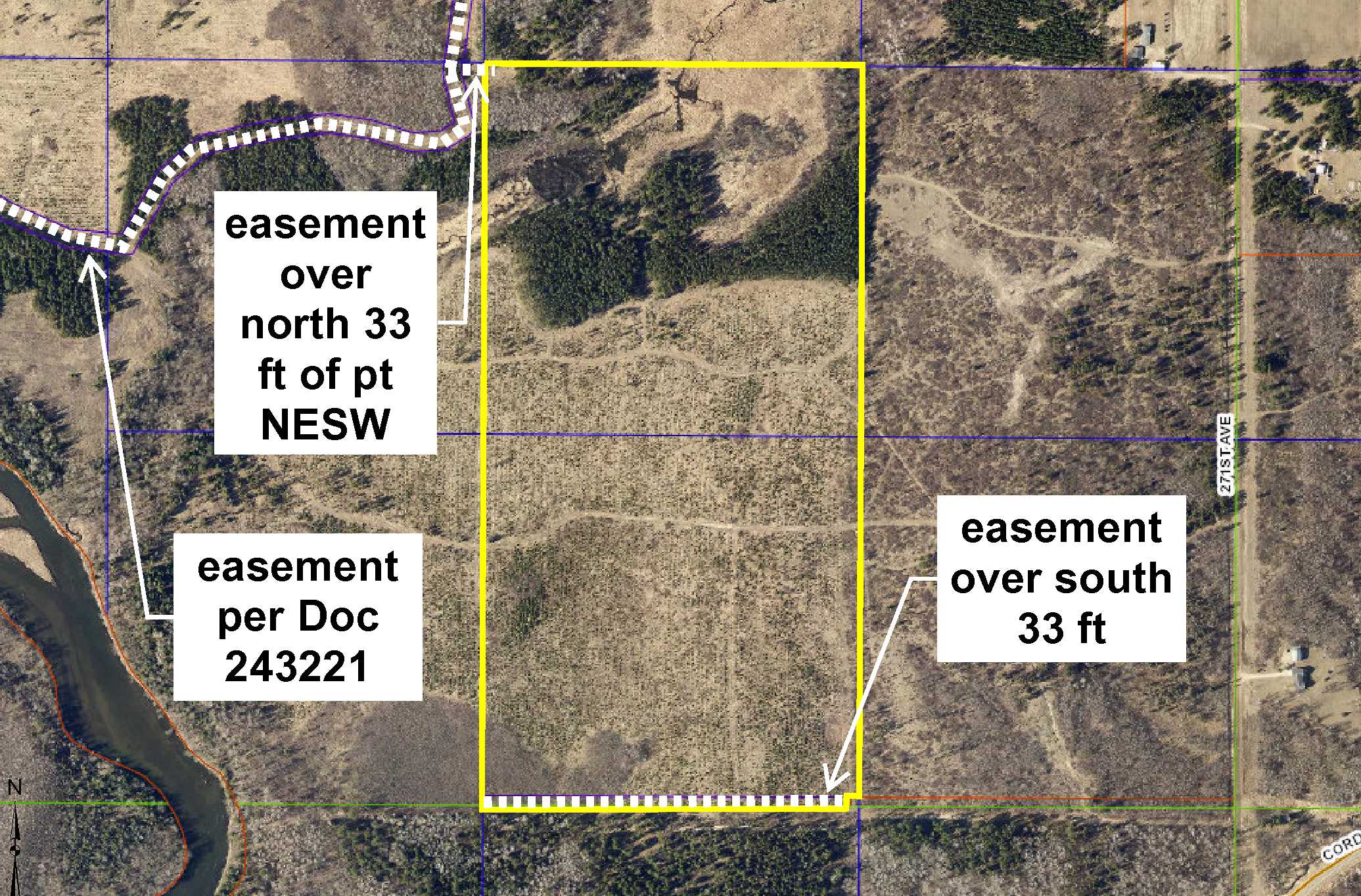
Secluded Potlatch land by the Crow Wing River southeast of Nimrod. Fairly level terrain lightly wooded with red pine, jack pine, and aspen. Creek runs through the northwest corner. Access via easements through adjoining land to the north. An easement along the south 33 ft serves as access to adjoining landowner to the south. Only a few miles from Strike WMA.
Main Property Info
Property ID
060144010 & 060144035
060144010 & 060144035
MLS Number
4919110
4919110
Status
Sold
Sold
List Price
$105,900
$105,900
Selling Price
$98,400
$98,400
Acres
79.97
79.97
Zoning
A-2 Mixed Agriculture
A-2 Mixed Agriculture
City
Verndale
Verndale
Township
Lyons Twp
Lyons Twp
State
MN
MN
Zip Code
56481
56481
County
Wadena
Wadena
Legal Description
NWSE & Pt SWSE, 14-136-33. Together with easement in Doc 216280 and other access easements. Subject to easement over south 33 ft and any other easements, restrictions, or reservations of record.
NWSE & Pt SWSE, 14-136-33. Together with easement in Doc 216280 and other access easements. Subject to easement over south 33 ft and any other easements, restrictions, or reservations of record.
Property Location
Directions
From the intersection of State Hwy 64 & Cass Co Rd 23 (60th St SW) north of Motley, west on Cass Co Rd 23 (60th St SW), which turns into Wadena Co Rd 7, for 5 miles. Right on Co Rd 140 (271st Ave) for 1.3 miles. Left (west & south) on easement trail 1.25 miles. Right on easement (not constructed) 110 ft into NW corner of the property.
From the intersection of State Hwy 64 & Cass Co Rd 23 (60th St SW) north of Motley, west on Cass Co Rd 23 (60th St SW), which turns into Wadena Co Rd 7, for 5 miles. Right on Co Rd 140 (271st Ave) for 1.3 miles. Left (west & south) on easement trail 1.25 miles. Right on easement (not constructed) 110 ft into NW corner of the property.
Access
Access is via easements of record from 271st Ave (Co Rd 140).
Access is via easements of record from 271st Ave (Co Rd 140).
Address
271st Ave (Co Rd 140)
271st Ave (Co Rd 140)
School District
Sebeka - 820
Sebeka - 820
Property Details
Dimensions (approx)
1320 x 2640 IRR
1320 x 2640 IRR
Utilities
Power Company
Todd-Wadena Electric (1-800-320-8932)
Todd-Wadena Electric (1-800-320-8932)
Waterfront
Waterfront Name
unnamed creek
unnamed creek
Waterfront Feet (approx)
985
985
Taxes & Fees
Tax Amount
$1,216
$1,216
Tax Year
2018
2018
Other Details
Section Number
14
14
Township Number
136
136
Range Number
33
33
Estimated Upland %
90
90
Estimated Wetland %
10
10
Additional Comments
Timber Comments
This property has been managed according to Forest Stewardship Council (FSC) standards. If timber value is important to you, seek the advice of a competent forester to determine species, volumes, and values.
This property has been managed according to Forest Stewardship Council (FSC) standards. If timber value is important to you, seek the advice of a competent forester to determine species, volumes, and values.
Disclosures
This property is in an unmapped FEMA area; however, the creek could be subject to flooding. Not surveyed; acreage and dimensions approximate based on county data and mapping; county disclaimers included by reference. Photos/maps for convenience only and not guaranteed; physically inspect prior to purchase. Any deer stands on the land are not property of seller and are not included in sale. Use seller-approved PA and addendum; closing dates the 3rd Wednesday each month.
This property is in an unmapped FEMA area; however, the creek could be subject to flooding. Not surveyed; acreage and dimensions approximate based on county data and mapping; county disclaimers included by reference. Photos/maps for convenience only and not guaranteed; physically inspect prior to purchase. Any deer stands on the land are not property of seller and are not included in sale. Use seller-approved PA and addendum; closing dates the 3rd Wednesday each month.


