

MLS Number : 4617847
Sold $38,500 - Hunting & Recreation
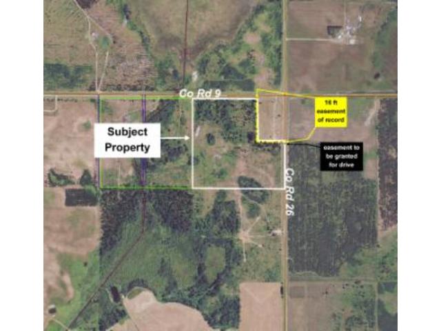
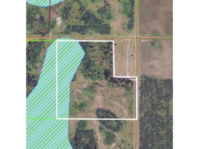
Potlatch land near Wadena, Sebeka, Nimrod, Crow Wing River, & Lyons State Forest. Level topo w/ spruce plantation & wetland in west. Paved co rd to north (w/ county 50 ft ROW parcel between) & along east. 16′ easement around exception area.
Main Property Info
Property ID
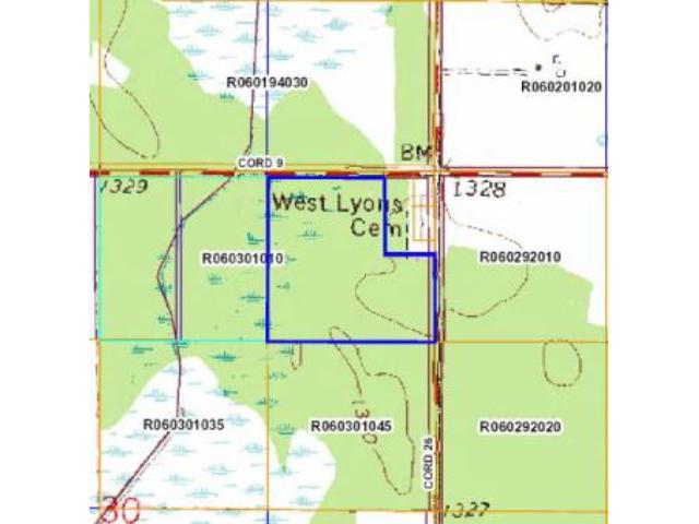
060301010, Pt of R060301010
060301010, Pt of R060301010
MLS Number
4617847
4617847
Status
Sold
Sold
List Price
$39,900
$39,900
Selling Price
$38,500
$38,500
Acres
33.060
33.060
Zoning
A-2 Mixed Agriculture
A-2 Mixed Agriculture
City
Verndale
Verndale
Township
Lyons Township
Lyons Township
State
MN
MN
Zip Code
56481
56481
County
Wadena
Wadena
Legal Description
NENE, 30-136-33, except the north 642 ft of the east 382 ft (PID# R060301025, R060301030, & R060301040) and except the north 50 ft. Subject to Co Rd 9 and Co Rd 26; 16 ft wide easement bordering the exception area (north 642 ft of the east 382 ft); easement for drive to exception area; and any other easements, restrictions, or reservations of record. (Legal description of record to govern.)
NENE, 30-136-33, except the north 642 ft of the east 382 ft (PID# R060301025, R060301030, & R060301040) and except the north 50 ft. Subject to Co Rd 9 and Co Rd 26; 16 ft wide easement bordering the exception area (north 642 ft of the east 382 ft); easement for drive to exception area; and any other easements, restrictions, or reservations of record. (Legal description of record to govern.)
Property Location
Directions
From intersection of US Hwy 71 & Co Rd 9 between Wadena & Sebeka, east on Co Rd 9 for 9 7/10 miles. NW corner of tract is approx 1/10 mile past address #22735 & is approx 50 ft south of rd centerline.
From intersection of US Hwy 71 & Co Rd 9 between Wadena & Sebeka, east on Co Rd 9 for 9 7/10 miles. NW corner of tract is approx 1/10 mile past address #22735 & is approx 50 ft south of rd centerline.
Access
Access to this property is via paved Co Rd 9 on the north (although a 50-ft right-of-way parcel owned by the county separates the tract from the road) and Co Rd 26 along the west side.
Access to this property is via paved Co Rd 9 on the north (although a 50-ft right-of-way parcel owned by the county separates the tract from the road) and Co Rd 26 along the west side.
GPS Coordinates
See map for coordinates to approx corners and points based on county mapping.
See map for coordinates to approx corners and points based on county mapping.
Address
PtNENE County Road 26
PtNENE County Road 26
School District
Sebeka - 820
Sebeka - 820
Property Details
Dimensions (approx)
938x1320x1652x938
938x1320x1652x938
Utilities
Available Utilities
Electric
Electric
On Site Utilities
None
None
Power Company
Todd-Wadena Electric (1-800-320-8932)
Todd-Wadena Electric (1-800-320-8932)
Taxes & Fees
Association Fee
$0
$0
Tax Amount
$397
$397
Tax With Assessments
$397
$397
Tax Year
2015
2015
Other Details
Section Number
30
30
Township Number
136
136
Range Number
33
33
Estimated Upland %
75
75
Estimated Wetland %
25
25
Additional Comments
Timber Comments
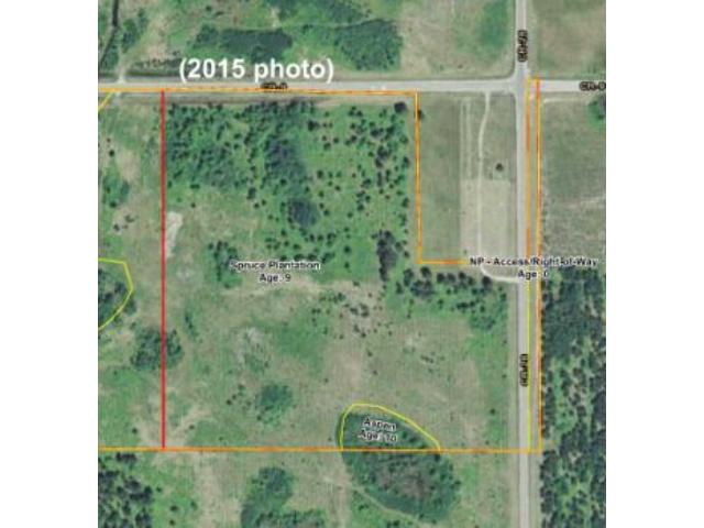
This property has been managed according to Forest Stewardship Council (FSC) standards. It's lightly wooded with spruce plantation. If timber value is important to you, seek the advice of a competent forester to determine species, volumes and values.
This property has been managed according to Forest Stewardship Council (FSC) standards. It's lightly wooded with spruce plantation. If timber value is important to you, seek the advice of a competent forester to determine species, volumes and values.
Hunting Comments
This property is near public land in MN firearms deer zone 246. Public Lyons State Forest land only 1.5 miles away provides additional hunting space in this area popular for hunting whitetail deer and bear.
This property is near public land in MN firearms deer zone 246. Public Lyons State Forest land only 1.5 miles away provides additional hunting space in this area popular for hunting whitetail deer and bear.
Disclosures
Subject to Co Rd 9 and Co Rd 26; 16 ft wide easement bordering the exception area (north 642 ft of the east 382 ft); easement for drive to exception area (see sketch and description in Supplements); and any other easements, restrictions, or reservations of record. A 50-ft right-of-way parcel owned by the county separates the tract from the Co Rd 9. Parcel split; acreage, dimensions, and taxes estimated based on county data and mapping; county disclaimers included by reference; subject to split approval. Not surveyed. Photos/maps for convenience only and not guaranteed; tree cover may be different than depicted; physically inspect prior to purchase. Any deer stands on the land are not property of seller and are not included in sale. Use seller-approved PA and addendum; closing dates the 2nd Wednesday each month.
Subject to Co Rd 9 and Co Rd 26; 16 ft wide easement bordering the exception area (north 642 ft of the east 382 ft); easement for drive to exception area (see sketch and description in Supplements); and any other easements, restrictions, or reservations of record. A 50-ft right-of-way parcel owned by the county separates the tract from the Co Rd 9. Parcel split; acreage, dimensions, and taxes estimated based on county data and mapping; county disclaimers included by reference; subject to split approval. Not surveyed. Photos/maps for convenience only and not guaranteed; tree cover may be different than depicted; physically inspect prior to purchase. Any deer stands on the land are not property of seller and are not included in sale. Use seller-approved PA and addendum; closing dates the 2nd Wednesday each month.
Additional Details
Approximate Dimensions:
938 x 592 x 382 x 678 x 1320 x 938 IRR
938 x 592 x 382 x 678 x 1320 x 938 IRR


