


MLS Number : 5549482
Sold - Home & Cabin Sites, Waterfront Properties
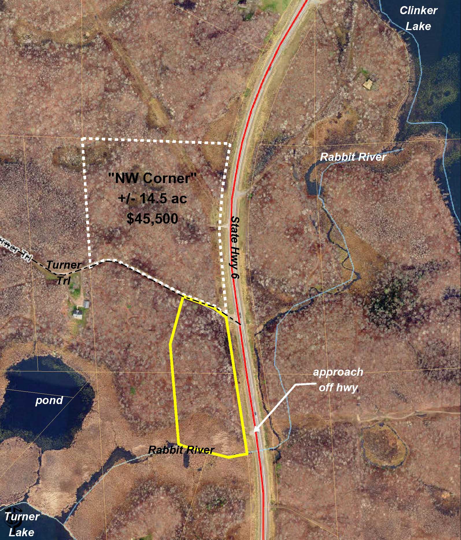
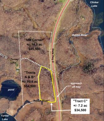
Generously-sized building lot with frontage on the Rabbit River. Conveniently located on State Hwy 6 north of Crosby near Rabbit Lake and Clinker Lake. There is an existing approach off the hwy and a trail leads through the south portion of the land. Turner Trail (a private easement rd) runs along the north boundary. Mostly upland with wetland along the river. Tract has been surveyed and denotes possible building site for a home or cabin in this popular vacation area.
Main Property Info
Property ID
Pt 930351100000009 & Pt 930351400000009
Pt 930351100000009 & Pt 930351400000009
MLS Number
5549482
5549482
Status
Sold
Sold
List Price
$32,000
$32,000
Acres
7.2
7.2
Zoning
Rural Residential 2.5 & Shoreland
Rural Residential 2.5 & Shoreland
City
Crosby
Crosby
Township
Wolford Twp
Wolford Twp
State
MN
MN
Zip Code
56441
56441
County
Crow Wing
Crow Wing
Legal Description
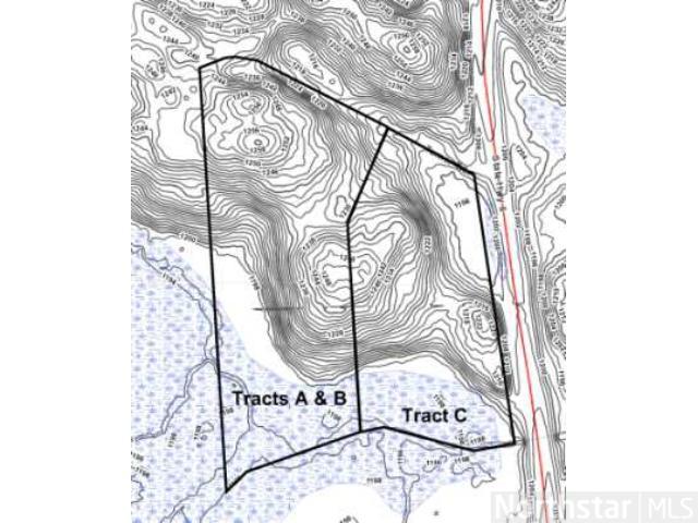
"Tract C" (Pts NENE & SENE, 35-047-29) described on survey lying w'ly of State Hwy 6 ROW. Subj to deed restrictions and any other easements, restrictions, or reservations of record. Legal desc of record to govern.
"Tract C" (Pts NENE & SENE, 35-047-29) described on survey lying w'ly of State Hwy 6 ROW. Subj to deed restrictions and any other easements, restrictions, or reservations of record. Legal desc of record to govern.
Property Location
Directions
From Crosby, north on State Hwy 6 approx 2 3/8 mile to the northeast corner of the property which is at the intersection of State Hwy 6 and Turner Trl.
From Crosby, north on State Hwy 6 approx 2 3/8 mile to the northeast corner of the property which is at the intersection of State Hwy 6 and Turner Trl.
Access
Excellent access to this property via State Hwy 6 along the entire east boundary and Turner Trl (a 66 ft wide private easement rd) along the north boundary. There is an existing approach off the hwy near the southeast corner of the tract, and a trail leads into and through the south part of the land.
Excellent access to this property via State Hwy 6 along the entire east boundary and Turner Trl (a 66 ft wide private easement rd) along the north boundary. There is an existing approach off the hwy near the southeast corner of the tract, and a trail leads into and through the south part of the land.
GPS Coordinates
Coordinates to approximate corners/points based on county mapping: NE corner at the intersection of State Hwy 6 and Turner Trl = 46.5152, -93.9602; SE corner along State Hwy 6 = 46.5130, -93.96; SW corner = 46.5133, -93.9616; NW corner along Turner Trl = 46.5155, -93.9613
Coordinates to approximate corners/points based on county mapping: NE corner at the intersection of State Hwy 6 and Turner Trl = 46.5152, -93.9602; SE corner along State Hwy 6 = 46.5130, -93.96; SW corner = 46.5133, -93.9616; NW corner along Turner Trl = 46.5155, -93.9613
Address
Tract C State Highway 6
Tract C State Highway 6
School District
Crosby-Ironton - 182
Crosby-Ironton - 182
Property Details
Dimensions (approx)
711x700x442x262
711x700x442x262
Utilities
Available Utilities
Electric
Electric
On Site Utilities
None
None
Power Company
Crow Wing Power (1-800-648-9401)
Crow Wing Power (1-800-648-9401)
Waterfront
Waterfront Name
Rabbit River
Rabbit River
Waterfront Number
R9999061
R9999061
Waterfront Feet (approx)
442
442
Taxes & Fees
Association Fee
$0
$0
Tax Amount
$150
$150
Tax Year
2019
2019
Other Details
Section Number
35
35
Township Number
047
047
Range Number
29
29
Estimated Upland %
65
65
Estimated Wetland %
35
35
Additional Comments
Disclosures
See survey for exact dimensions and acreage. Acreage represented (7.2) is based on approximate measurements using county GIS mapping and excluding highway right-of-way; boundaries and acreage (9.0+/-) on survey include highway right-of-way. Parcel split; taxes estimated based on county data and mapping; county disclaimers included by reference; subject to split approval. Photos/maps for convenience only and not guaranteed; tree cover may be different than depicted; physically inspect prior to purchase.
See survey for exact dimensions and acreage. Acreage represented (7.2) is based on approximate measurements using county GIS mapping and excluding highway right-of-way; boundaries and acreage (9.0+/-) on survey include highway right-of-way. Parcel split; taxes estimated based on county data and mapping; county disclaimers included by reference; subject to split approval. Photos/maps for convenience only and not guaranteed; tree cover may be different than depicted; physically inspect prior to purchase.
Additional Details
Waterfront Comments:
Rabbit River, which runs between Clinker Lake and Turner Lake, meanders along the south boundary of this tract.
Rabbit River, which runs between Clinker Lake and Turner Lake, meanders along the south boundary of this tract.


