
MLS Number : 5617321
Sold $99,900 - Hunting & Recreation
Enjoy plenty of privacy on this 80-acre hunting and recreational site with a 10-year old red pine plantation and 16 to 75-year old aspen. This property is in a good hunting area for deer, turkey, and waterfowl. Property is close to nearby Dry Sand Lake and Farnham Lake WMAs for additional outdoor enjoyment. Wahoo Valley is just minutes away for dining and beverages.
Main Property Info
Property ID
Pt 11-005-1101
Pt 11-005-1101
MLS Number
5617321
5617321
Status
Sold
Sold
List Price
$99,900
$99,900
Selling Price
$99,900
$99,900
Acres
80
80
Zoning
Shoreland, Agriculture, Forestry
Shoreland, Agriculture, Forestry
City
Staples
Staples
Township
Byron Twp
Byron Twp
State
MN
MN
Zip Code
56479
56479
County
Cass
Cass
Legal Description
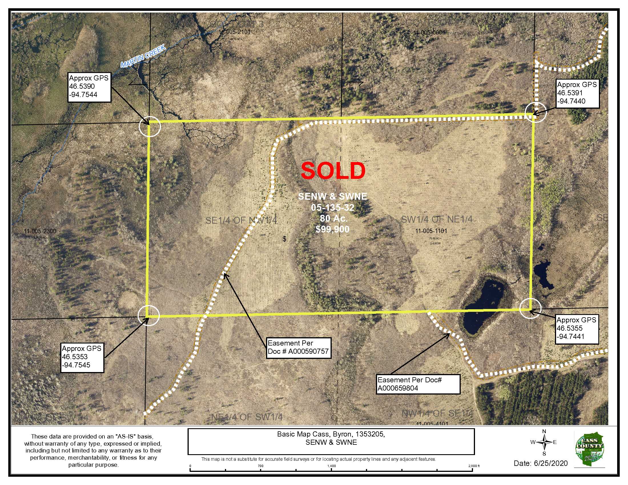
SENW & SWNE, 05-135-32, Cass County, Minnesota Together with easement as reserved over NESE & NWSE, 05-135-32, in Doc. A000659804. Subject to easement in Doc. A000590757 & any other easements, restrictions, or reservations of record. Easements granted, reserved, retained will include terms governing shared use of easements.
SENW & SWNE, 05-135-32, Cass County, Minnesota Together with easement as reserved over NESE & NWSE, 05-135-32, in Doc. A000659804. Subject to easement in Doc. A000590757 & any other easements, restrictions, or reservations of record. Easements granted, reserved, retained will include terms governing shared use of easements.
Property Location
Directions
From the intersection of State Hwy 210 & State Hwy 64 in Motley, go north on State Hwy 64 for 15.5 miles. Turn left (W) on 72nd St. SW for 2.1 miles. Turn left (S) on 87th Ave. SW and go 0.6 miles to easement access on right (W). Continue 0.3 miles westerly, then 0.1 mile northwesterly on easement trail to tract entrance. (Approx. GPS Point of Entrance Access: 46.535468, -94.746922)
From the intersection of State Hwy 210 & State Hwy 64 in Motley, go north on State Hwy 64 for 15.5 miles. Turn left (W) on 72nd St. SW for 2.1 miles. Turn left (S) on 87th Ave. SW and go 0.6 miles to easement access on right (W). Continue 0.3 miles westerly, then 0.1 mile northwesterly on easement trail to tract entrance. (Approx. GPS Point of Entrance Access: 46.535468, -94.746922)
Access
Access is per easement rounte across adjoining land. See route in directions.
Access is per easement rounte across adjoining land. See route in directions.
GPS Coordinates
Coordinates to approximate corners/points based on county mapping: NW: 46.5390, -94.7544 NE: 46.5391, -94.7440 SE: 46.5355, -94.7441 SW: 46.5353, -94.7545
Coordinates to approximate corners/points based on county mapping: NW: 46.5390, -94.7544 NE: 46.5391, -94.7440 SE: 46.5355, -94.7441 SW: 46.5353, -94.7545
Address
TBD 87th Ave SW, Staples, MN 56479
TBD 87th Ave SW, Staples, MN 56479
School District
Staples-Motley - 2170
Staples-Motley - 2170
Property Details
Pasture Acres
0
0
Tillable Acres
0
0
Wooded Acres
65
65
Dimensions (approx)
2640 X 1320 X 2640 X 1320
2640 X 1320 X 2640 X 1320
Utilities
Available Utilities
None
None
On Site Utilities
None
None
Power Company
Todd-Wadena Electric (1-800-320-8932)
Todd-Wadena Electric (1-800-320-8932)
Waterfront
Waterfront Name
N/A
N/A
Waterfront Number
N/A
N/A
Waterfront Feet (approx)
N/A
N/A
Taxes & Fees
Has Association Fee
No
No
Association Fee
$0
$0
Association Fee Includes
0
0
Tax Amount
$732
$732
Assessment Amount
0
0
Tax With Assessments
$732
$732
Assessment Pending
No
No
Assessment Description
None
None
Tax Year
2020
2020
Other Details
Section Number
05
05
Township Number
135
135
Range Number
32
32
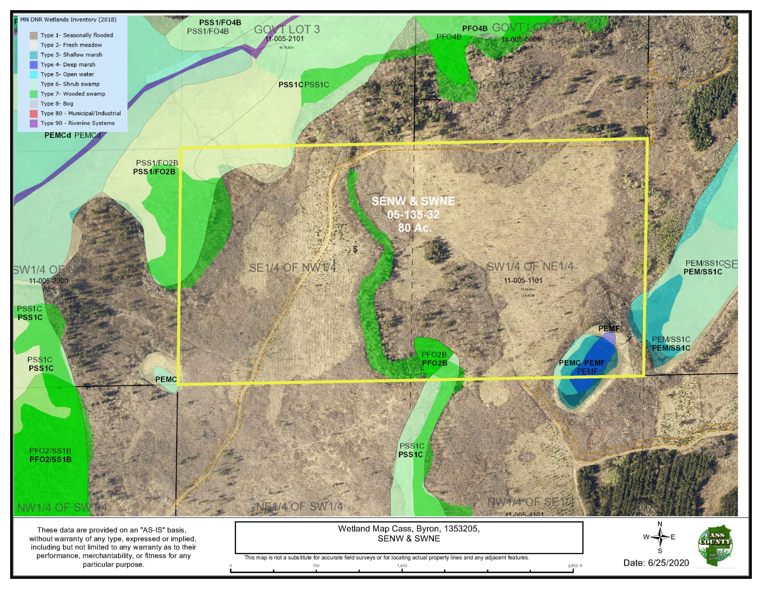
Estimated Upland %
83
83
Estimated Wetland %
17
17
Additional Comments
Timber Comments
10 year-old Red Pine plantation 16 to 75-year old Aspen
10 year-old Red Pine plantation 16 to 75-year old Aspen
Hunting Comments
Deer Permit Area: #246
Deer Permit Area: #246
Disclosures
Easement(s) affect this property. See legal description and maps for details. Shared easements affect this property and easements granted and reserved/retained will include terms governing shared use of the easements. See legal description and maps for details. Acreage, dimensions, and taxes estimated based on county data and mapping or seller data; county disclaimers included by reference; subject to split approval if necessary. Not surveyed. Photos/maps and GPS coordinates for convenience only and not guaranteed; physically inspect prior to purchase. Any deer stands on the land are not property of seller and are not included in sale. Use seller-approved PA and Addendum; closing dates the 3rd Wednesday each month. Seller is Potlatch Minnesota Timberlands LLC, a business entity under the laws of the State of Delaware.
Easement(s) affect this property. See legal description and maps for details. Shared easements affect this property and easements granted and reserved/retained will include terms governing shared use of the easements. See legal description and maps for details. Acreage, dimensions, and taxes estimated based on county data and mapping or seller data; county disclaimers included by reference; subject to split approval if necessary. Not surveyed. Photos/maps and GPS coordinates for convenience only and not guaranteed; physically inspect prior to purchase. Any deer stands on the land are not property of seller and are not included in sale. Use seller-approved PA and Addendum; closing dates the 3rd Wednesday each month. Seller is Potlatch Minnesota Timberlands LLC, a business entity under the laws of the State of Delaware.


