


MLS Number : 5608312
Sold $56,000 - Hunting & Recreation
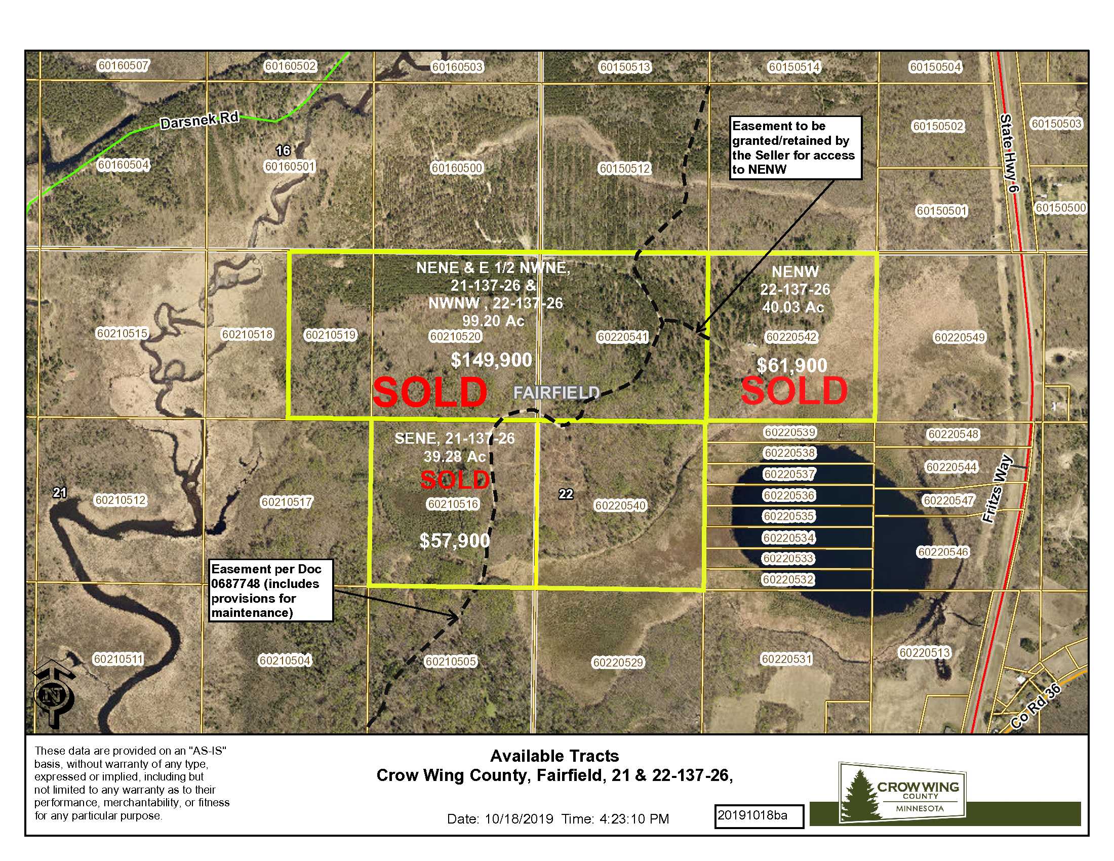
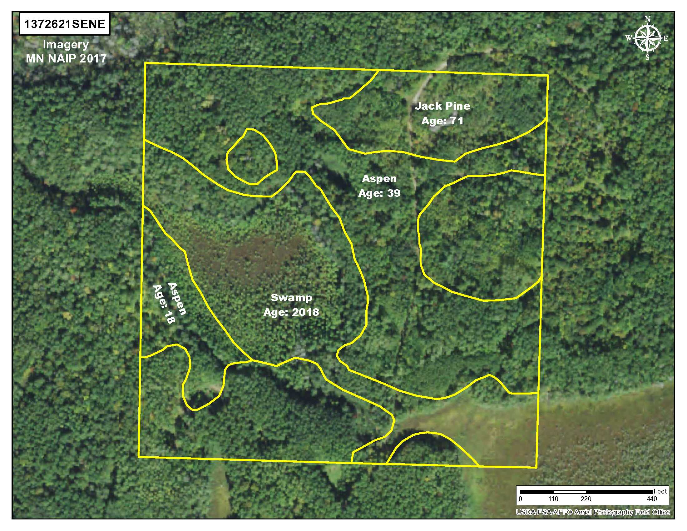
A nice 40 acre parcel in a very private location yet near Crosslake and Emily. The property is both open and wooded with rolling terrain, a mix of jack pine and aspen. In an area with low population density.
Main Property Info
Property ID
60210516
60210516
MLS Number
5608312
5608312
Status
Sold
Sold
List Price
$57,900
$57,900
Selling Price
$56,000
$56,000
Acres
39.28
39.28
Zoning
RR10 & Shoreline
RR10 & Shoreline
City
Emily
Emily
Township
Fairfield Twp
Fairfield Twp
State
MN
MN
Zip Code
56447
56447
County
Crow Wing
Crow Wing
Legal Description
SENE, 21-137-26, Crow Wing County, Minnesota. Together with, subject to and seller to retain easement in Doc #0687748. Subject to easements, restrictions and reservations of record.
SENE, 21-137-26, Crow Wing County, Minnesota. Together with, subject to and seller to retain easement in Doc #0687748. Subject to easements, restrictions and reservations of record.
Property Location
Directions
From the intersection of State Hwy 6 and Co Rd 36 (12.9) miles north of Crosby); West on Co Rd 36 for 1.2 miles to easement road on the North side of Co Rd 36; Northerly and Easterly on the easement road for 1.4 miles to the southerly boundary of the tract. Approximate GPS coordinate entrance of this location is 46.6658
From the intersection of State Hwy 6 and Co Rd 36 (12.9) miles north of Crosby); West on Co Rd 36 for 1.2 miles to easement road on the North side of Co Rd 36; Northerly and Easterly on the easement road for 1.4 miles to the southerly boundary of the tract. Approximate GPS coordinate entrance of this location is 46.6658
Access
Access is via private easements over private property, as described in Document #0687748, from Co Rd 36 (about 1.2 miles west of State Hwy 6). See mapping for the course of the easement road.
Access is via private easements over private property, as described in Document #0687748, from Co Rd 36 (about 1.2 miles west of State Hwy 6). See mapping for the course of the easement road.
GPS Coordinates
Coordinates to approximate corners/points based on county mapping: NW: 46.6695, -93.9723, NE: 46.6695, -93.9671, SE: 46.6659, -93.9672, SW: 46.6659, -93.9724
Coordinates to approximate corners/points based on county mapping: NW: 46.6695, -93.9723, NE: 46.6695, -93.9671, SE: 46.6659, -93.9672, SW: 46.6659, -93.9724
Address
TBD Co Rd 36, Emily, MN 56447
TBD Co Rd 36, Emily, MN 56447
School District
Crosby-Ironton - 182
Crosby-Ironton - 182
Property Details
Pasture Acres
0
0
Tillable Acres
0
0
Dimensions (approx)
1320 x 1320 x 1320 x 1320
1320 x 1320 x 1320 x 1320
Utilities
Available Utilities
None
None
On Site Utilities
None
None
Power Company
Crow Wing Power (1-800-648-9401)
Crow Wing Power (1-800-648-9401)
Waterfront
Waterfront Name
N/A
N/A
Waterfront Number
N/A
N/A
Waterfront Feet (approx)
N/A
N/A
Taxes & Fees
Has Association Fee
No
No
Association Fee
$0
$0
Association Fee Includes
N/A
N/A
Tax Amount
$310
$310
Assessment Amount
0
0
Tax With Assessments
$310
$310
Assessment Pending
No
No
Assessment Description
N/A
N/A
Tax Year
2020
2020
Other Details
Section Number
21
21
Township Number
137
137
Range Number
26
26
Additional Comments
Timber Comments
Jack Pine and Aspen from 40 to 72 years old.
Jack Pine and Aspen from 40 to 72 years old.
Hunting Comments
Special CWD deer hunting permit area 604
Special CWD deer hunting permit area 604
Disclosures
Easements and shared easements affect this property. See legal description and map for details. Easements granted and reserved/retained will include terms governing shared use of easements. Acreage, dimensions and taxes estimated based on county data and mapping or seller data; county disclaimers included by reference; subject to split approval if necessary. Not surveyed. Photos/maps & GPS coordinates for convenience only and not guaranteed; physically inspect prior to purchase. Any deer stands on the land are not property of the seller and are not included in sale. An easement affects this property. See Map Easement Supplement for details.
Easements and shared easements affect this property. See legal description and map for details. Easements granted and reserved/retained will include terms governing shared use of easements. Acreage, dimensions and taxes estimated based on county data and mapping or seller data; county disclaimers included by reference; subject to split approval if necessary. Not surveyed. Photos/maps & GPS coordinates for convenience only and not guaranteed; physically inspect prior to purchase. Any deer stands on the land are not property of the seller and are not included in sale. An easement affects this property. See Map Easement Supplement for details.


