MLS Number : 5259571
Sold $60,900 - Home & Cabin Sites, Hunting & Recreation
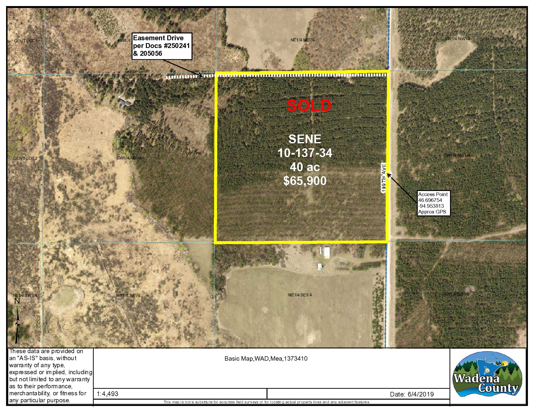
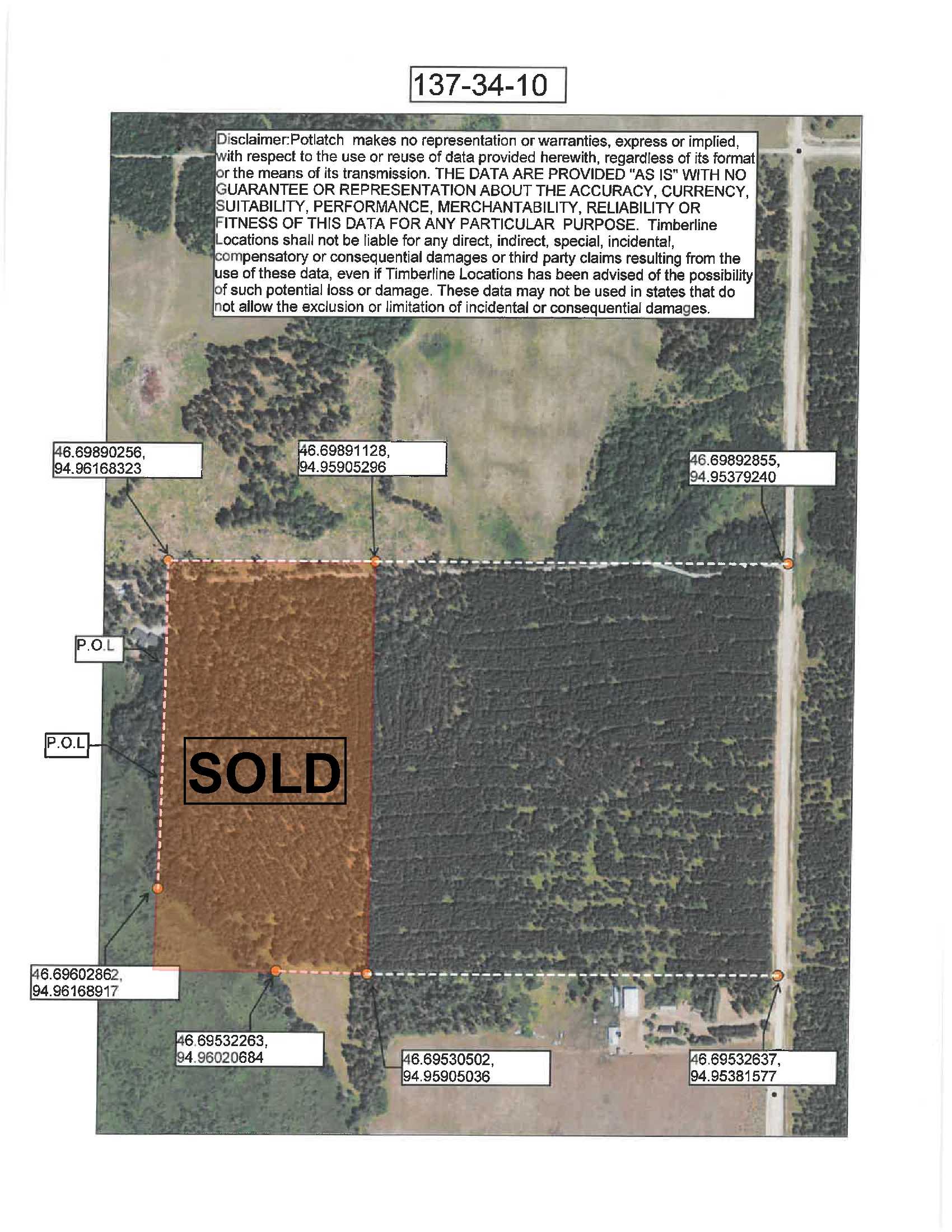
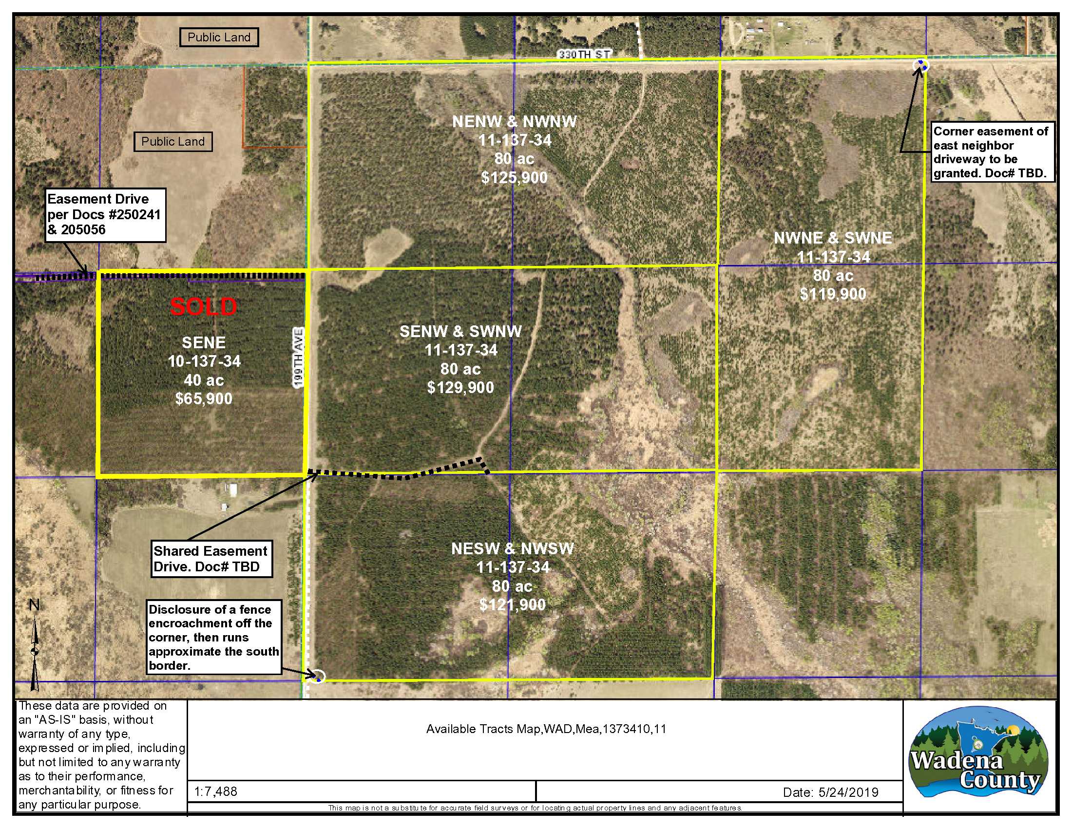
This 40 acre PotlatchDeltic tract is well situated near state forest lands just minutes away, and adjoins public land on it’s entire northern border. This would make an excellent hunting/recreational destination all within a short drive to Park Rapids and area lakes. This is a nice upland wooded tract with potential timber income boasting red pine and jack pine age 35-52 yrs. Easy access off of 199th Avenue.
Main Property Info
Property ID
R070101040
R070101040
MLS Number
5259571
5259571
Status
Sold
Sold
List Price
$65,900
$65,900
Selling Price
$60,900
$60,900
Acres
40
40
Zoning
A-2, Agriculture
A-2, Agriculture
City
Menahga
Menahga
Township
Meadow Twp
Meadow Twp
State
MN
MN
Zip Code
56464
56464
County
Wadena
Wadena
Legal Description
SENE, 10-137-34, Wadena County, Minnesota. Together with and subject to easements in Doc# 250241 and Doc# 205056. Subject to any other easements, restrictions or reservations of record.
SENE, 10-137-34, Wadena County, Minnesota. Together with and subject to easements in Doc# 250241 and Doc# 205056. Subject to any other easements, restrictions or reservations of record.
Property Location
Directions
From Staples MN head west on Hwy 10. Drive 5.4 miles & turn north onto Co Rd 26. Drive 18.7 miles & turn right (north) onto Nimrod Ave (Co Rd 12). Drive 0.6 miles & turn left (north) onto Co Rd 14. Drive 6.4 miles & turn right (north) onto 199th Ave Drive 0.6 miles to the access point for the property on left (west.)
From Staples MN head west on Hwy 10. Drive 5.4 miles & turn north onto Co Rd 26. Drive 18.7 miles & turn right (north) onto Nimrod Ave (Co Rd 12). Drive 0.6 miles & turn left (north) onto Co Rd 14. Drive 6.4 miles & turn right (north) onto 199th Ave Drive 0.6 miles to the access point for the property on left (west.)
Access
Access point to the property off of 199th Ave at the east middle of the tract. (Approx GPS point of access: Lat 46.696754, Lon -94.953813)
Access point to the property off of 199th Ave at the east middle of the tract. (Approx GPS point of access: Lat 46.696754, Lon -94.953813)
GPS Coordinates
Coordinates to approximate corners/points based on county mapping: NW: 46.698911, -94.959052 NE: 46.698928, -94.953792 SE: 46.695326, -94.953815 SW: 46.695305, -94.959050
Coordinates to approximate corners/points based on county mapping: NW: 46.698911, -94.959052 NE: 46.698928, -94.953792 SE: 46.695326, -94.953815 SW: 46.695305, -94.959050
Address
SENE TBD 199th Ave., Menahga, MN 56464
SENE TBD 199th Ave., Menahga, MN 56464
School District
Sebeka - 820
Sebeka - 820
Property Details
Pasture Acres
0
0
Wooded Acres
39
39
Dimensions (approx)
1320 x 1320 x 1320 x 1320
1320 x 1320 x 1320 x 1320
Utilities
Available Utilities
Electric
Electric
On Site Utilities
None
None
Power Company
Todd-Wadena Electric (1-800-320-8932)
Todd-Wadena Electric (1-800-320-8932)
Waterfront
Waterfront Name
N/A
N/A
Waterfront Number
N/A
N/A
Waterfront Feet (approx)
N/A
N/A
Waterfront Comments
N/A
N/A
Taxes & Fees
Has Association Fee
No
No
Association Fee
$0
$0
Association Fee Includes
N/A
N/A
Tax Amount
$654
$654
Assessment Amount
0
0
Tax With Assessments
$654
$654
Assessment Pending
No
No
Assessment Description
N/A
N/A
Tax Year
2019
2019
Other Details
Section Number
10
10
Township Number
137
137
Range Number
34
34
Estimated Upland %
99
99
Estimated Wetland %
1
1
Additional Comments
Timber Comments
Red Pine Age 35-52 yrs. Jack Pine 35 yrs.
Red Pine Age 35-52 yrs. Jack Pine 35 yrs.
Hunting Comments
Deer Permit Area: 246
Deer Permit Area: 246
Disclosures
Easements affect this property. Acreage, dimensions, and taxes estimated based on county data and mapping or seller data; county disclaimers included by reference; subject to split approval if necessary. Not surveyed. Photos/maps and GPS coordinates for convenience only and not guaranteed; physically inspect prior to purchase. Any deer stands on the land are not property of seller and are not included in sale. Use seller-approved PA and addendum; closing dates the 3rd Wednesday each month.
Easements affect this property. Acreage, dimensions, and taxes estimated based on county data and mapping or seller data; county disclaimers included by reference; subject to split approval if necessary. Not surveyed. Photos/maps and GPS coordinates for convenience only and not guaranteed; physically inspect prior to purchase. Any deer stands on the land are not property of seller and are not included in sale. Use seller-approved PA and addendum; closing dates the 3rd Wednesday each month.