


MLS Number : 5235982
Sold $136,000 - Hunting & Recreation
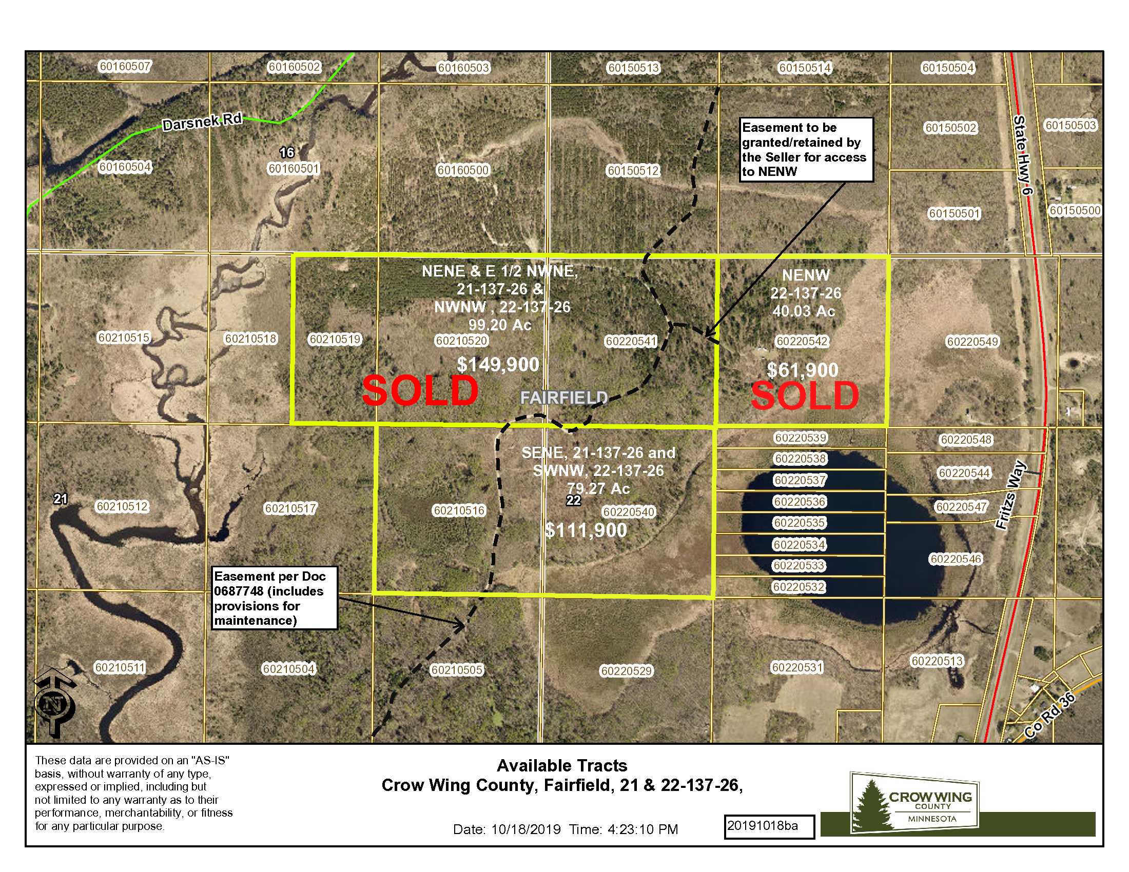
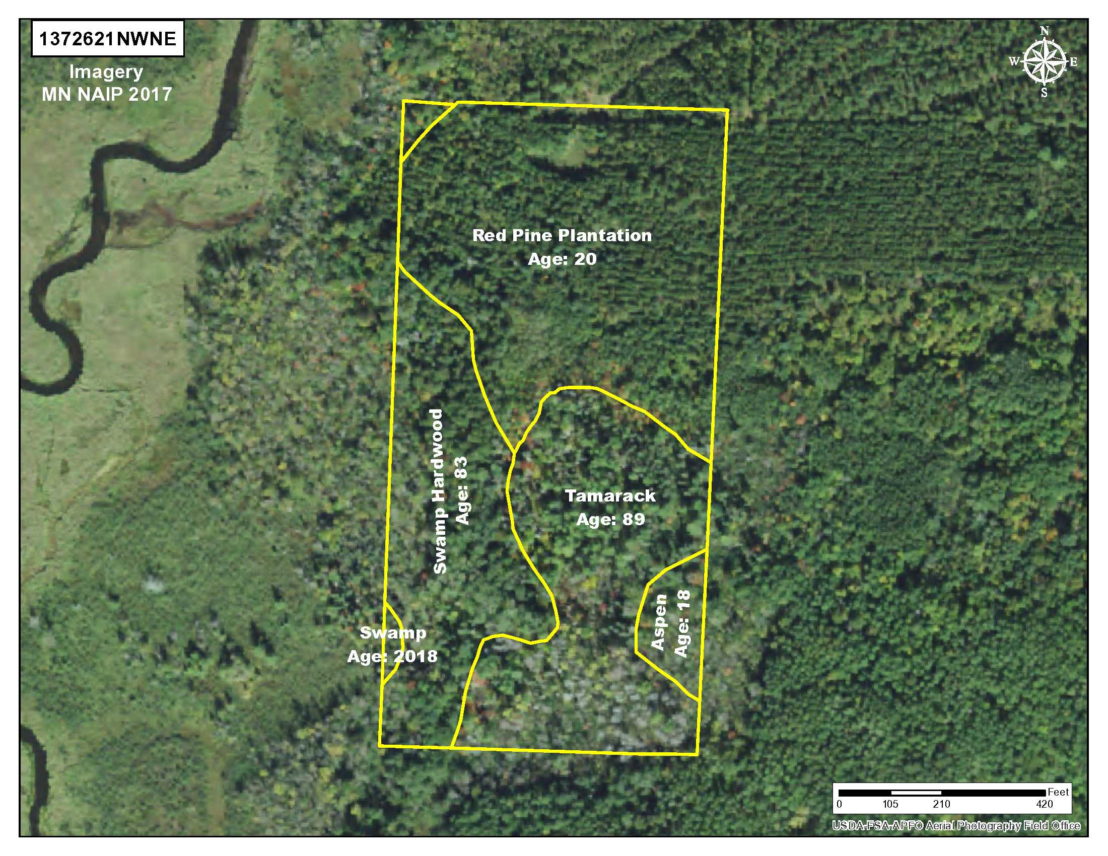
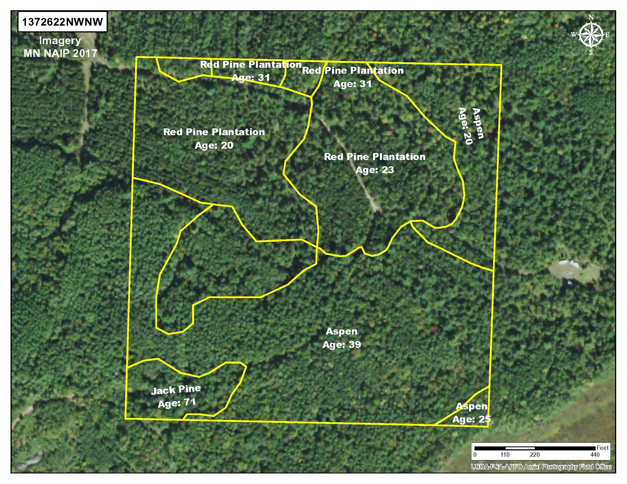
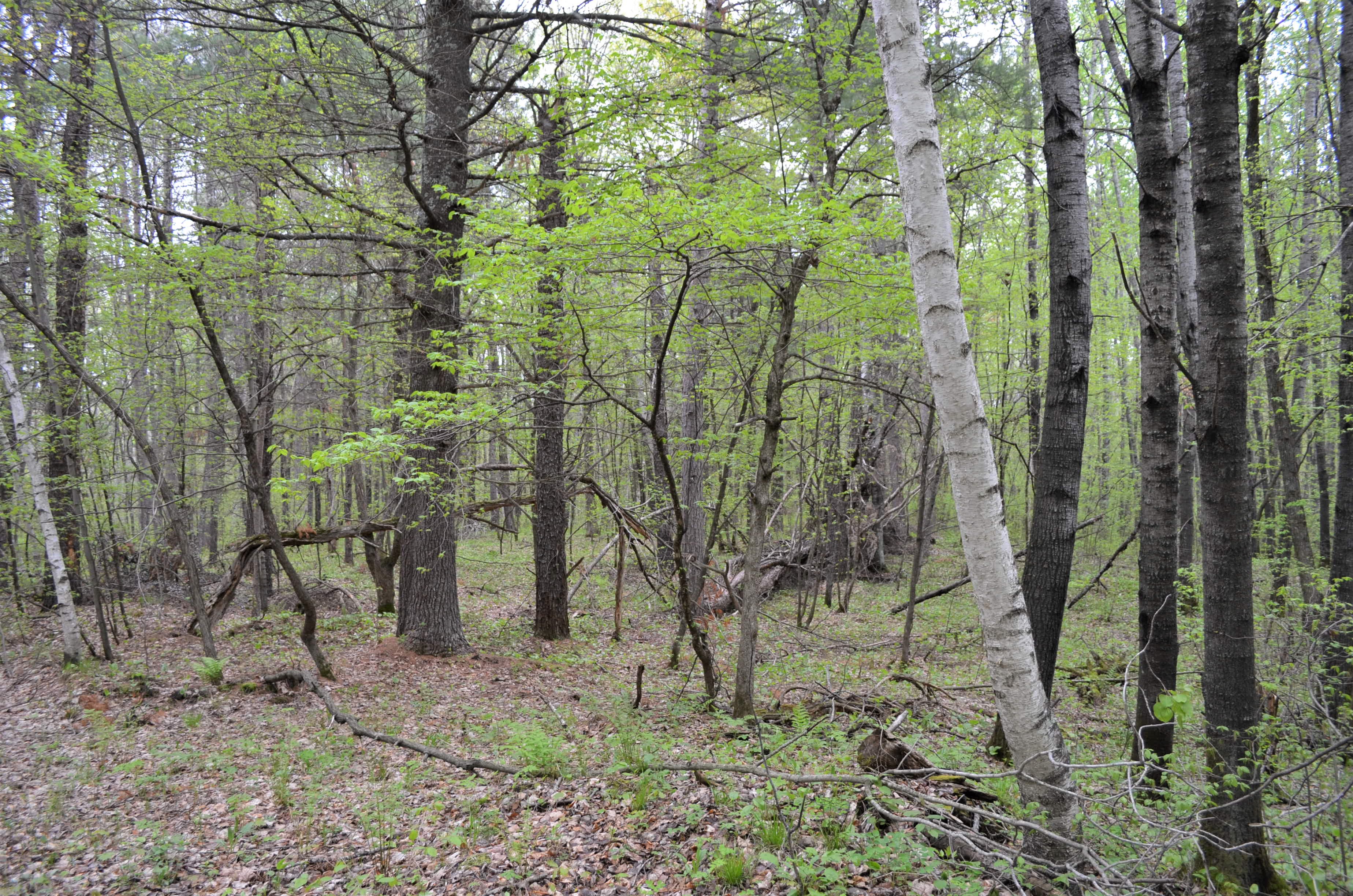
Great hunting/recreational land right in the heart of lake country! This 99-acre PotlatchDeltic tract is minutes away from Crosslake, Emily and Crosby. Gently rolling terrain and a mix of red pine, jack pine, tamarack and aspen make this an excellent hunting/recreational land investment. Crow Wing State Forest adjoins on the northwest portion. Big Al’s Bar and Grill and Olson’s Mercantile are minutes away at the intersection of Co Rd 36 and Hwy 6. Crosslake is a little more than 7 miles to the west. Additional land is available.
Main Property Info
Property ID
60210519(Legacy 600211200A00009) 60210520(Legacy 600211100000009) 60220541(Legacy 600222200000009)
60210519(Legacy 600211200A00009) 60210520(Legacy 600211100000009) 60220541(Legacy 600222200000009)
MLS Number
5235982
5235982
Status
Sold
Sold
List Price
$149,900
$149,900
Selling Price
$136,000
$136,000
Acres
99.20
99.20
Zoning
RR 10 & Shoreland in the NW & SE corners
RR 10 & Shoreland in the NW & SE corners
City
Crosby
Crosby
Township
Fairfield Twp
Fairfield Twp
State
MN
MN
Zip Code
56441
56441
County
Crow Wing
Crow Wing
Legal Description
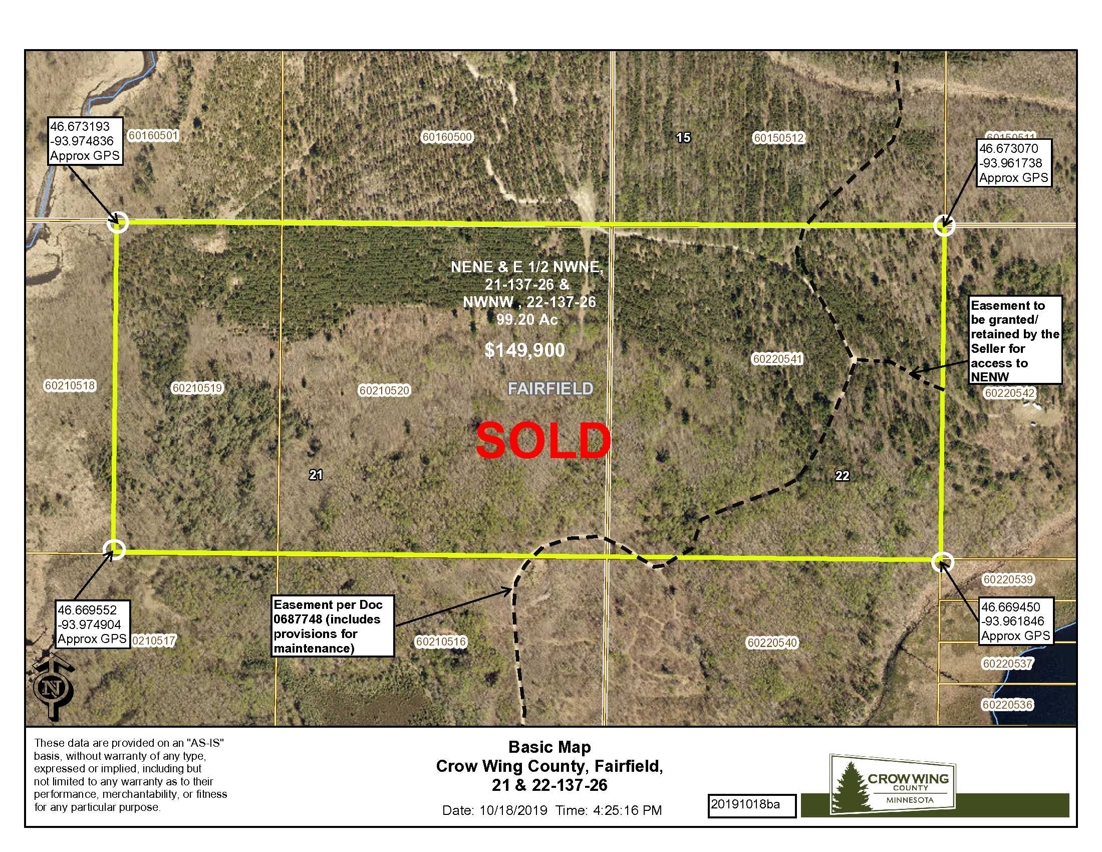
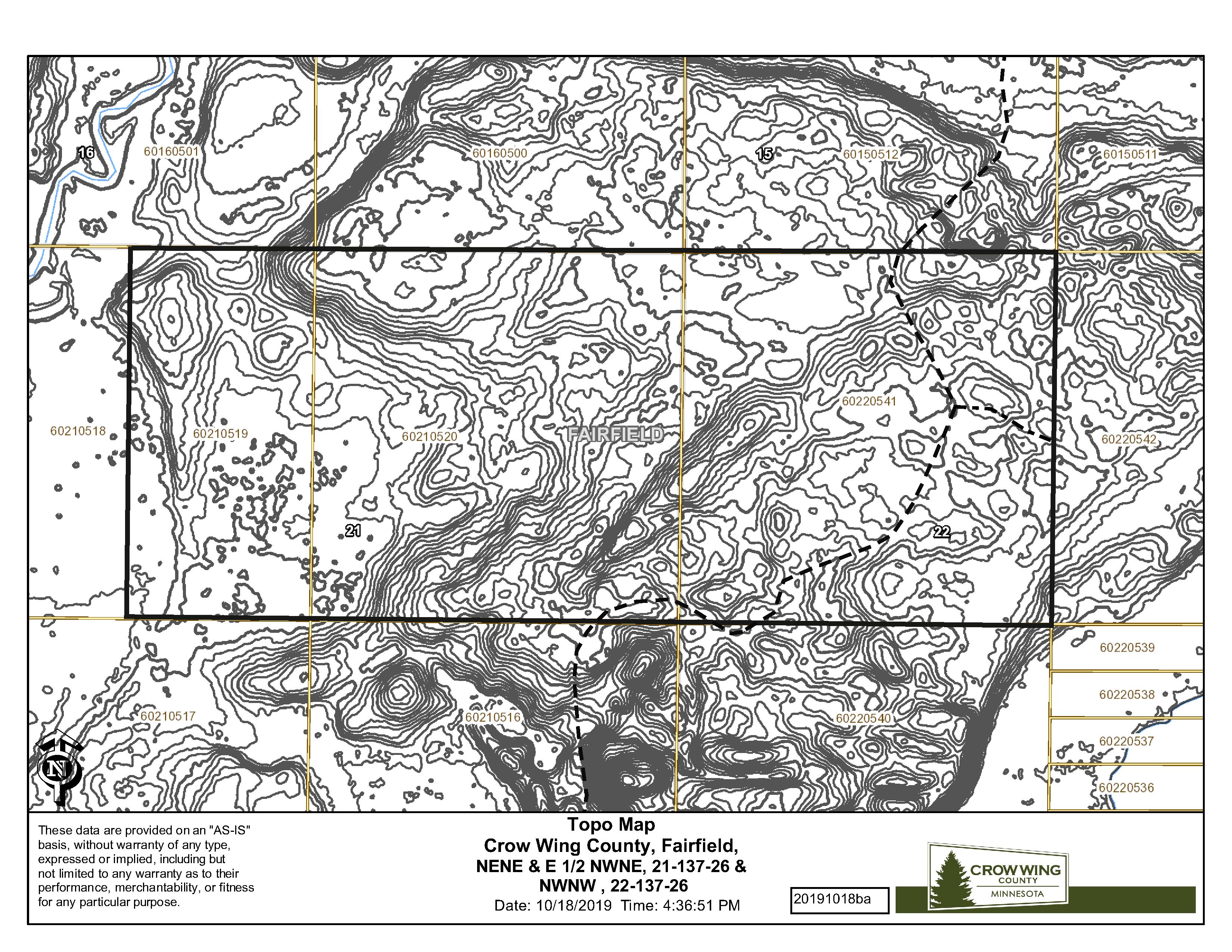
See Exhibit A. NENE & E1/2NWNE, 21-137-26, & NWNW, 22-137-26. Together with and subject to easements. Subject to any other easements, restrictions, or reservations of record.
See Exhibit A. NENE & E1/2NWNE, 21-137-26, & NWNW, 22-137-26. Together with and subject to easements. Subject to any other easements, restrictions, or reservations of record.
Property Location
Directions
From the intersection of Hwy 6 and Co Rd 36 (12.9 miles north of Crosby MN); West on Co Rd 36 1.2 miles to easement road on the North side of Co Rd 36; Northerly and Easterly on the easement road 0.9 miles to the southerly boundary of the tract. Approximate GPS coordinate to this location is: Lat 46.669494, Lon -93.968340
From the intersection of Hwy 6 and Co Rd 36 (12.9 miles north of Crosby MN); West on Co Rd 36 1.2 miles to easement road on the North side of Co Rd 36; Northerly and Easterly on the easement road 0.9 miles to the southerly boundary of the tract. Approximate GPS coordinate to this location is: Lat 46.669494, Lon -93.968340
Access
Access is via private easements over private property, as described in Document #0687748, from Co Rd 36 (about 1.2 miles west of State Hwy 6). See mapping for the course of the easement road.
Access is via private easements over private property, as described in Document #0687748, from Co Rd 36 (about 1.2 miles west of State Hwy 6). See mapping for the course of the easement road.
GPS Coordinates
Coordinates to approximate corners/points based on county mapping: NW: 46.673193, -93.974836 NE: 46.673070, -93.961738 SE: 46.669450, -93.961846 SW: 46.669552, -93.974904
Coordinates to approximate corners/points based on county mapping: NW: 46.673193, -93.974836 NE: 46.673070, -93.961738 SE: 46.669450, -93.961846 SW: 46.669552, -93.974904
Address
TBD Pt 21-137-26 & Pt 22-137-26, Off Co Rd 36, Fairfield Twp, Crosby
TBD Pt 21-137-26 & Pt 22-137-26, Off Co Rd 36, Fairfield Twp, Crosby
School District
Crosby-Ironton - 182
Crosby-Ironton - 182
Property Details
Pasture Acres
None
None
Tillable Acres
None
None
Wooded Acres
85
85
Dimensions (approx)
3300 x 1320 x 3300 x 1320
3300 x 1320 x 3300 x 1320
Utilities
Available Utilities
None
None
On Site Utilities
None
None
Power Company
Crow Wing Power (1-800-648-9401)
Crow Wing Power (1-800-648-9401)
Waterfront
Waterfront Name
None
None
Waterfront Number
None
None
Waterfront Feet (approx)
None
None
Taxes & Fees
Has Association Fee
No
No
Association Fee
$0
$0
Association Fee Includes
N/A
N/A
Tax Amount
$964
$964
Assessment Amount
0
0
Tax With Assessments
$964
$964
Assessment Pending
No
No
Assessment Description
N/A
N/A
Tax Year
2019
2019
Other Details
Section Number
21 & 22
21 & 22
Township Number
137
137
Range Number
26
26
Estimated Upland %
89
89
Estimated Wetland %
11
11
Additional Comments
Timber Comments
Combination of Red Pine 20-31 years. Aspen 18-39 years. Jack Pine 71 years. Tamarack 89 years.
Combination of Red Pine 20-31 years. Aspen 18-39 years. Jack Pine 71 years. Tamarack 89 years.
Hunting Comments
Deer Permit Area: 604
Deer Permit Area: 604
Disclosures
Easement(s) affect this property. See legal description and maps for details. Shared easements affect this property and easements granted and reserved/retained will include terms governing shared use of the easements. FEMA mapping indicates this property is affected by FEMA in the Western border. Acreage, dimensions, and taxes are estimated based on county data and mapping or seller data; county disclaimers included by reference; subject to split approval if necessary. Not surveyed. Photos/maps and GPS coordinates for convenience only and are not guaranteed; physically inspect prior to purchase. Any deer stands on the land are not property of seller and are not included in sale. Use seller approved Purchase Agreement. Closing dates are the 3rd Wednesday of the month.
Easement(s) affect this property. See legal description and maps for details. Shared easements affect this property and easements granted and reserved/retained will include terms governing shared use of the easements. FEMA mapping indicates this property is affected by FEMA in the Western border. Acreage, dimensions, and taxes are estimated based on county data and mapping or seller data; county disclaimers included by reference; subject to split approval if necessary. Not surveyed. Photos/maps and GPS coordinates for convenience only and are not guaranteed; physically inspect prior to purchase. Any deer stands on the land are not property of seller and are not included in sale. Use seller approved Purchase Agreement. Closing dates are the 3rd Wednesday of the month.

