

MLS Number : 5138448
Sold $92,000 - Home & Cabin Sites, Hunting & Recreation
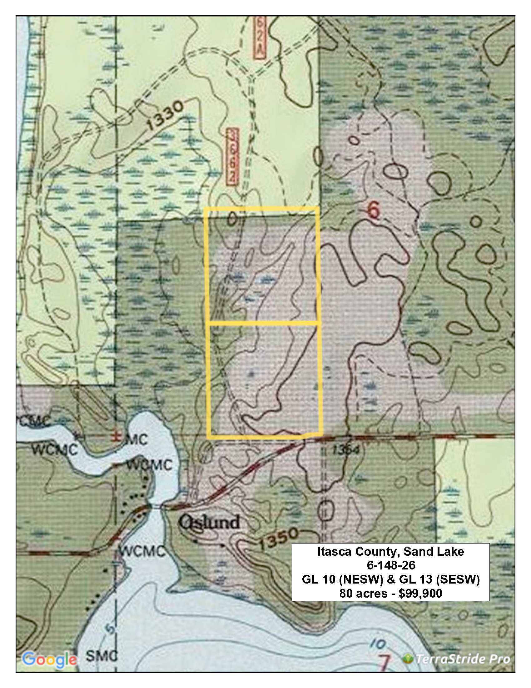
This property is approximately 80 acres and is near the public access to Sand Lake and Little Sand Lake in Itasca County. The land has rolling topography, mature timber and has scattered wetlands making this an attractive hunting and recreational property. Bowstring Lake and Winnibigoshish, in the Deer River area, are also close for more great fishing. There’s considerable public land in the area for more recreation and hunting opportunities. West Bowstring Snow Trail is less than 1/2 mile to the east and you can access all the snow trails in Itasca County here: Itasca Snow Trails . Deer River is the largest town in the area and is approx. 30 miles away.
Main Property Info
Property ID
35-006-3500 & 35-006-3200
35-006-3500 & 35-006-3200
MLS Number
5138448
5138448
Status
Sold
Sold
List Price
$99,900
$99,900
Selling Price
$92,000
$92,000
Acres
82.94
82.94
Zoning
Residential-Single Family
Residential-Single Family
City
Deer River
Deer River
Township
Sand Lake Twp
Sand Lake Twp
State
MN
MN
Zip Code
56680
56680
County
Itasca
Itasca
Legal Description
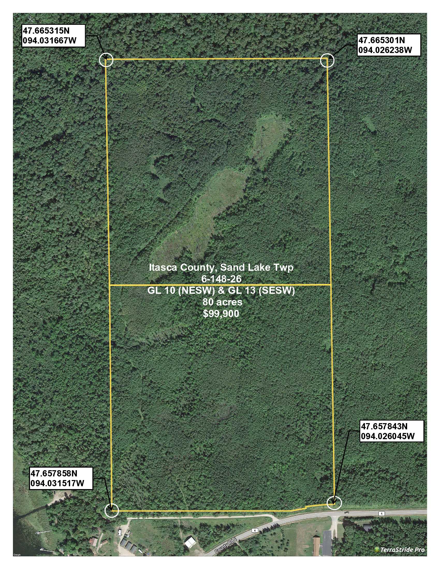
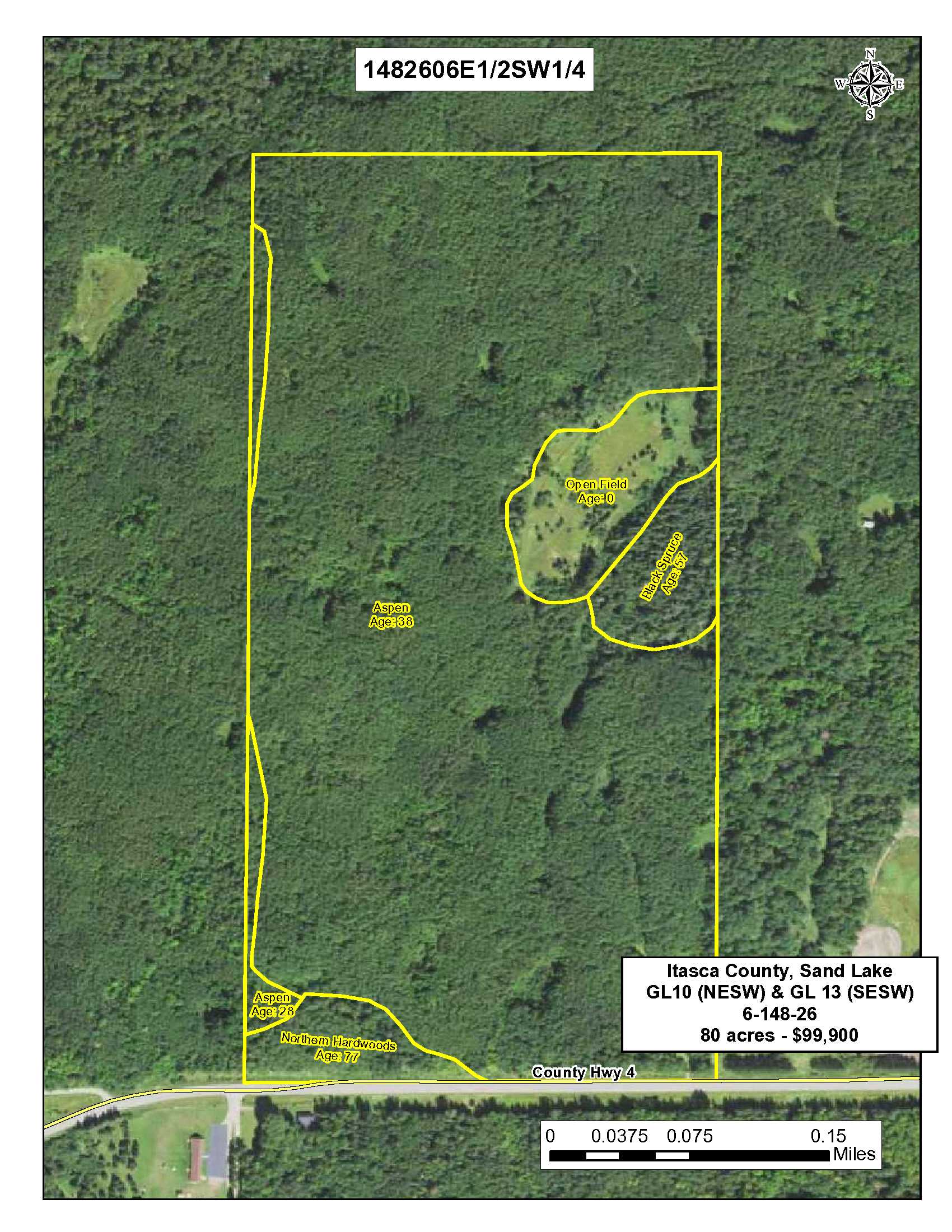
GL 10 (also known as the NESW) and GL 13 (also known as the SESW), 6-148-26, Itasca County. Subject to easements, restrictions and reservations of record, if any.
GL 10 (also known as the NESW) and GL 13 (also known as the SESW), 6-148-26, Itasca County. Subject to easements, restrictions and reservations of record, if any.
Property Location
Directions
From Deer River at the intersection of Hwy 2 and County Road 46 (White Oak Casino location); northwest on County Road 46 for 20 miles: North (right) on County Road 34 4.7 miles to intersection with County Road 4; continue North on County Road 4 4.5 miles to Rice Lake Public Access Road on the North (left) side. Property runs along the North side of the road. Barney’s Resort is across the road to the South.
From Deer River at the intersection of Hwy 2 and County Road 46 (White Oak Casino location); northwest on County Road 46 for 20 miles: North (right) on County Road 34 4.7 miles to intersection with County Road 4; continue North on County Road 4 4.5 miles to Rice Lake Public Access Road on the North (left) side. Property runs along the North side of the road. Barney’s Resort is across the road to the South.
Access
The Rice Lake Public Access Road runs along the southerly boundary of the property. The southeast corner of the property actually touches County Road 4. A trail runs into the property from Rice Lake Access Road.
The Rice Lake Public Access Road runs along the southerly boundary of the property. The southeast corner of the property actually touches County Road 4. A trail runs into the property from Rice Lake Access Road.
GPS Coordinates
Coordinates to approximate corners/points based on county mapping: SE: 47.657843N/094.026045W, SW: 47.657858N/094.031517W, NW: 47665315N/094.031667W, NE: 47.665301N/094.026238W
Coordinates to approximate corners/points based on county mapping: SE: 47.657843N/094.026045W, SW: 47.657858N/094.031517W, NW: 47665315N/094.031667W, NE: 47.665301N/094.026238W
Address
TBD County Road 4, Spring Lake
TBD County Road 4, Spring Lake
School District
Deer River - 317
Deer River - 317
Property Details
Wooded Acres
Approx. 67
Approx. 67
Dimensions (approx)
1320 x 2640 x 1320 x 2640
1320 x 2640 x 1320 x 2640
Utilities
Available Utilities
Electric, Telephone
Electric, Telephone
On Site Utilities
None
None
Power Company
North Itasca Electric (1-800-762-4048)
North Itasca Electric (1-800-762-4048)
Taxes & Fees
Tax Amount
$956
$956
Tax With Assessments
$956
$956
Tax Year
2018
2018
Other Details
Section Number
6
6
Township Number
148
148
Range Number
26
26
Estimated Upland %
84%
84%
Estimated Wetland %
16%
16%
Additional Comments
Timber Comments
This property is primarily mature Aspen at 38 years of age and could be harvested in a short time.
This property is primarily mature Aspen at 38 years of age and could be harvested in a short time.
Hunting Comments
The property is located in Hunting Zone 197 and this area of Northern Minnesota and is known for good hunting. Whitetail deer, grouse, bear and waterfowl are common.
The property is located in Hunting Zone 197 and this area of Northern Minnesota and is known for good hunting. Whitetail deer, grouse, bear and waterfowl are common.
Disclosures
Parcel split; acreage, dimensions, and taxes estimated based on county data and mapping or seller data; county disclaimers included by reference; subject to split approval if necessary. Not surveyed. Photos/maps and GPS coordinates for convenience only and not guaranteed; physically inspect prior to purchase. Any deer stands on the land are not property of seller and are not included in sale. Use seller-approved PA and addendum; closing dates the 3rd Wednesday each month.
Parcel split; acreage, dimensions, and taxes estimated based on county data and mapping or seller data; county disclaimers included by reference; subject to split approval if necessary. Not surveyed. Photos/maps and GPS coordinates for convenience only and not guaranteed; physically inspect prior to purchase. Any deer stands on the land are not property of seller and are not included in sale. Use seller-approved PA and addendum; closing dates the 3rd Wednesday each month.