

MLS Number : 5235437
Sold $53,900 - Hunting & Recreation
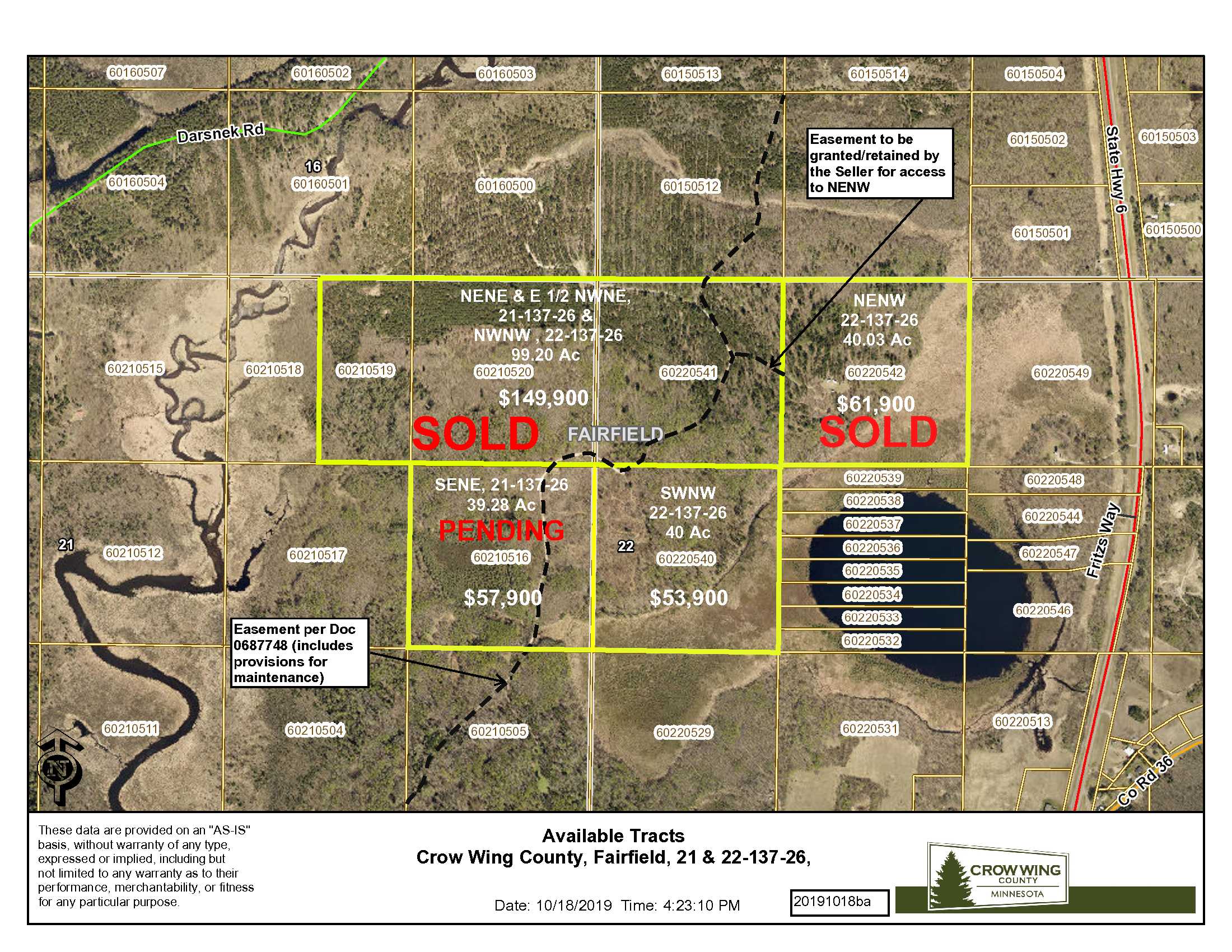
A great hunting and recreational tract off the beaten path yet conveniently close to Crosslake, Emily and Crosby. This 40-acre PotlatchDeltic parcel has both open and wooded rolling terrain with a mix of jack pine and aspen to make this an excellent land investment. Property is in an area with low population density and additional adjoining land is available. Big Al’s Bar and Grill is minutes away and Crosslake is just a little over 7 miles to the west with a US Army COE Campground on the Whitefish Chain, dining, restaurants and shopping.
Main Property Info
Property ID
60220540
60220540
MLS Number
5235437
5235437
Status
Sold
Sold
List Price
$53,900
$53,900
Selling Price
$53,900
$53,900
Acres
40
40
Zoning
RR10 & Shoreline
RR10 & Shoreline
City
Crosby
Crosby
Township
Fairfield Twp
Fairfield Twp
State
MN
MN
Zip Code
56447
56447
County
Crow Wing
Crow Wing
Legal Description
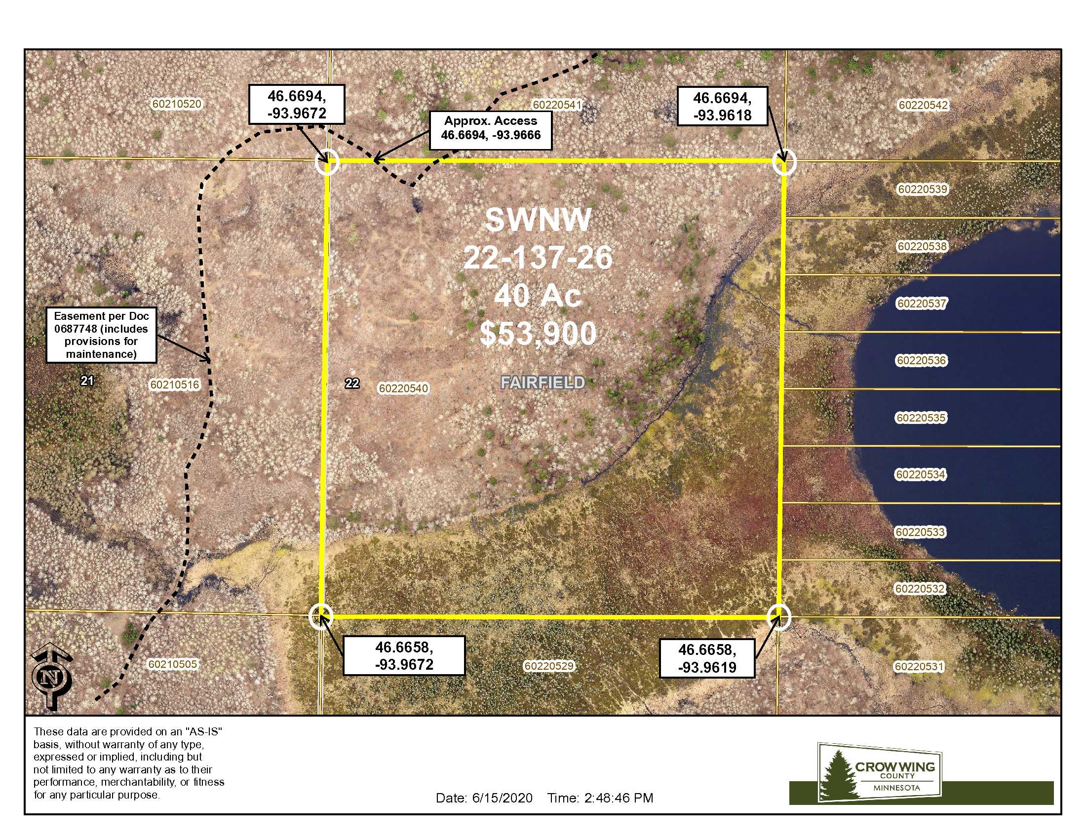
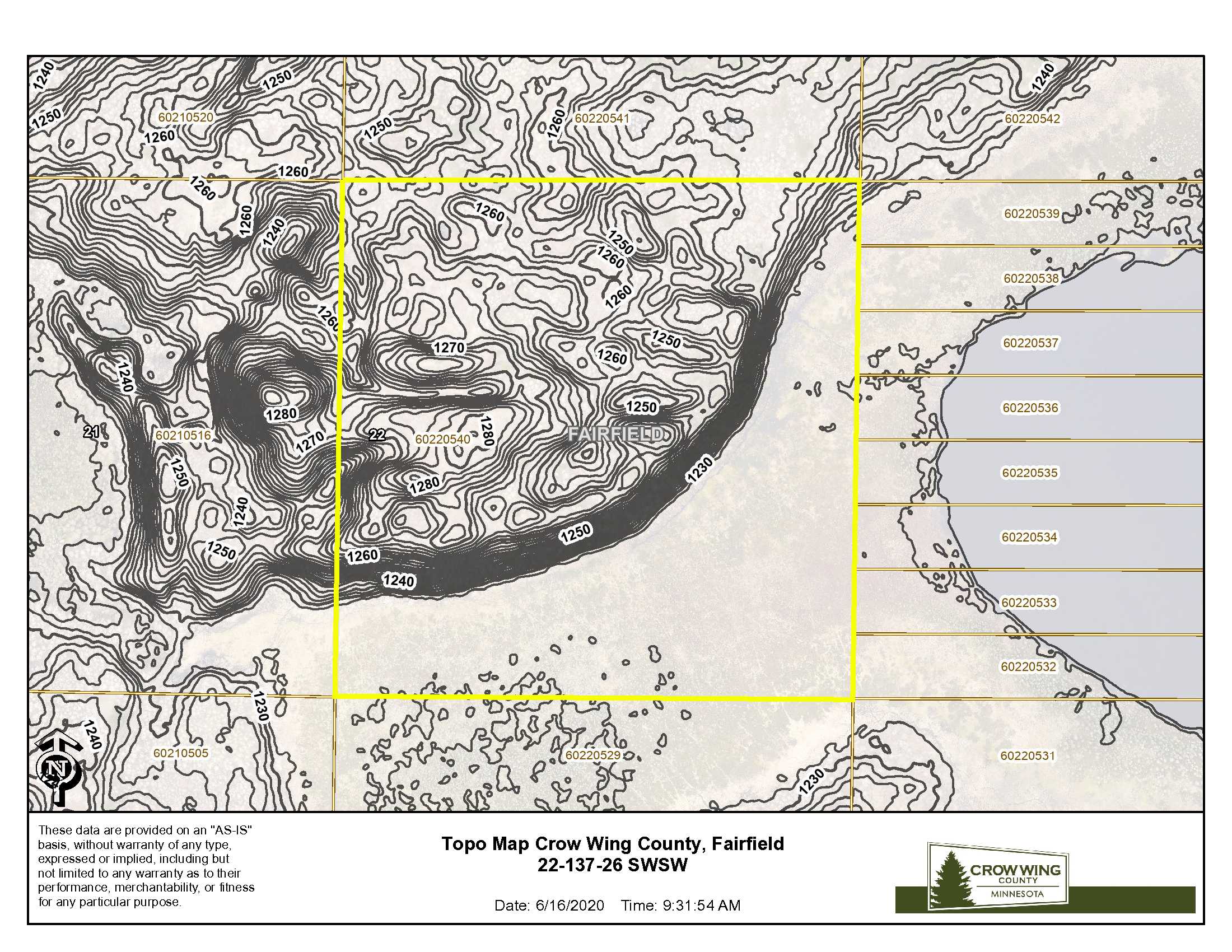
SWNW, 22-137-26, Crow Wing County, Minnesota. Together with and subject to easement in Doc 0687748. Subject to any other easements, restrictions, or reservations of record. Seller to retain those portions of easement in said Doc 0687748 crossing said SENE and said SWNW. Note: Easement(s) granted and/or reserved will include terms governing shared use of the easement(s).
SWNW, 22-137-26, Crow Wing County, Minnesota. Together with and subject to easement in Doc 0687748. Subject to any other easements, restrictions, or reservations of record. Seller to retain those portions of easement in said Doc 0687748 crossing said SENE and said SWNW. Note: Easement(s) granted and/or reserved will include terms governing shared use of the easement(s).
Property Location
Directions
From the intersection of Hwy 6 and Co Rd 36 (12.9 miles north of Crosby MN); West on Co Rd 36 1.2 miles to easement road on the North side of Co Rd 36; Northerly and Easterly on the easement road 1.7 miles to the northwest corner entry to the tract. Approximate GPS coordinate entrance of this location is: 46.6694, -93.9666.
From the intersection of Hwy 6 and Co Rd 36 (12.9 miles north of Crosby MN); West on Co Rd 36 1.2 miles to easement road on the North side of Co Rd 36; Northerly and Easterly on the easement road 1.7 miles to the northwest corner entry to the tract. Approximate GPS coordinate entrance of this location is: 46.6694, -93.9666.
Access
Access is via private easements over private property, as described in Document #0687748, from Co Rd 36 (about 1.2 miles west of State Hwy 6). See mapping for the course of the easement road.
Access is via private easements over private property, as described in Document #0687748, from Co Rd 36 (about 1.2 miles west of State Hwy 6). See mapping for the course of the easement road.
GPS Coordinates
Coordinates to approximate corners/points based on county mapping: NW: 46.6694, -93.9672 NE: 46.6694, -93.9618 SE: 46.6658, 93.9619 SW: 46.6658, -93.9672
Coordinates to approximate corners/points based on county mapping: NW: 46.6694, -93.9672 NE: 46.6694, -93.9618 SE: 46.6658, 93.9619 SW: 46.6658, -93.9672
Address
TBD Co Rd 36, Emily, MN 56447
TBD Co Rd 36, Emily, MN 56447
School District
Crosby-Ironton - 182
Crosby-Ironton - 182
Property Details
Pasture Acres
0
0
Tillable Acres
0
0
Dimensions (approx)
1320 x 1320 x 1320 x 1320
1320 x 1320 x 1320 x 1320
Utilities
Available Utilities
None
None
On Site Utilities
None
None
Power Company
Crow Wing Power (1-800-648-9401)
Crow Wing Power (1-800-648-9401)
Waterfront
Waterfront Name
None
None
Waterfront Number
None
None
Waterfront Feet (approx)
None
None
Taxes & Fees
Has Association Fee
No
No
Association Fee
$0
$0
Tax Amount
$284
$284
Assessment Amount
0
0
Tax With Assessments
$284
$284
Assessment Pending
No
No
Assessment Description
None
None
Tax Year
2020
2020
Other Details
Section Number
22
22
Township Number
137
137
Range Number
26
26
Additional Comments
Timber Comments
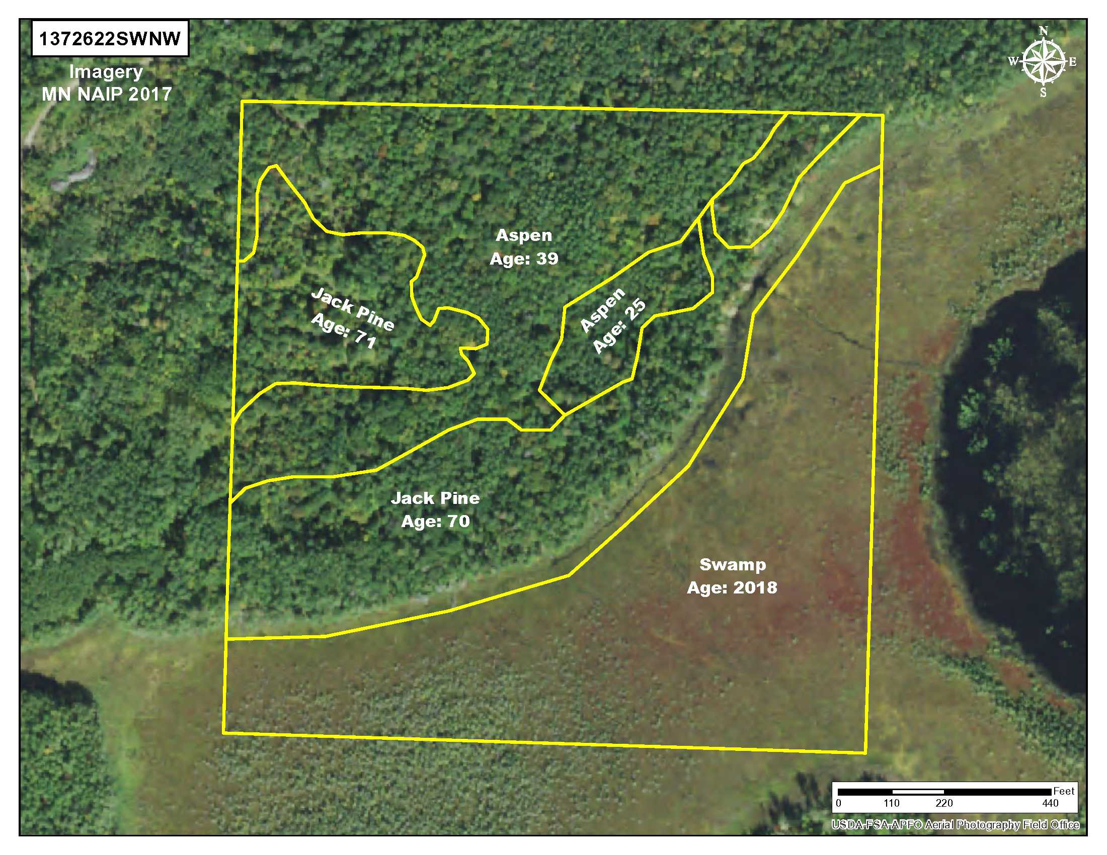
This tract boasts timber cover of various ages: Jack Pine and Aspen from 40 to 72 years.
This tract boasts timber cover of various ages: Jack Pine and Aspen from 40 to 72 years.
Hunting Comments
Deer Permit Area: 604
Deer Permit Area: 604
Disclosures
Easements affect this property. See legal description and maps for details. Shared easements affect this property and easements granted and reserved/retained will include terms governing shared use of the easements. Acreage, dimensions, and taxes estimated based on county data and mapping or seller data; county disclaimers included by reference; subject to split approval if necessary. Not surveyed. Photos/maps & GPS coordinates for convenience only and not guaranteed; physically inspect prior to purchase. Any deer stands on the land are not property of seller and are not included in sale. An easement affects this property. Use seller approved Purchase Agreement. Closing dates are the 3rd Wednesday of each month.
Easements affect this property. See legal description and maps for details. Shared easements affect this property and easements granted and reserved/retained will include terms governing shared use of the easements. Acreage, dimensions, and taxes estimated based on county data and mapping or seller data; county disclaimers included by reference; subject to split approval if necessary. Not surveyed. Photos/maps & GPS coordinates for convenience only and not guaranteed; physically inspect prior to purchase. Any deer stands on the land are not property of seller and are not included in sale. An easement affects this property. Use seller approved Purchase Agreement. Closing dates are the 3rd Wednesday of each month.

