


MLS Number : 4720796
Sold $54,000 - Hunting & Recreation
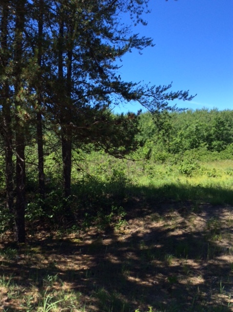
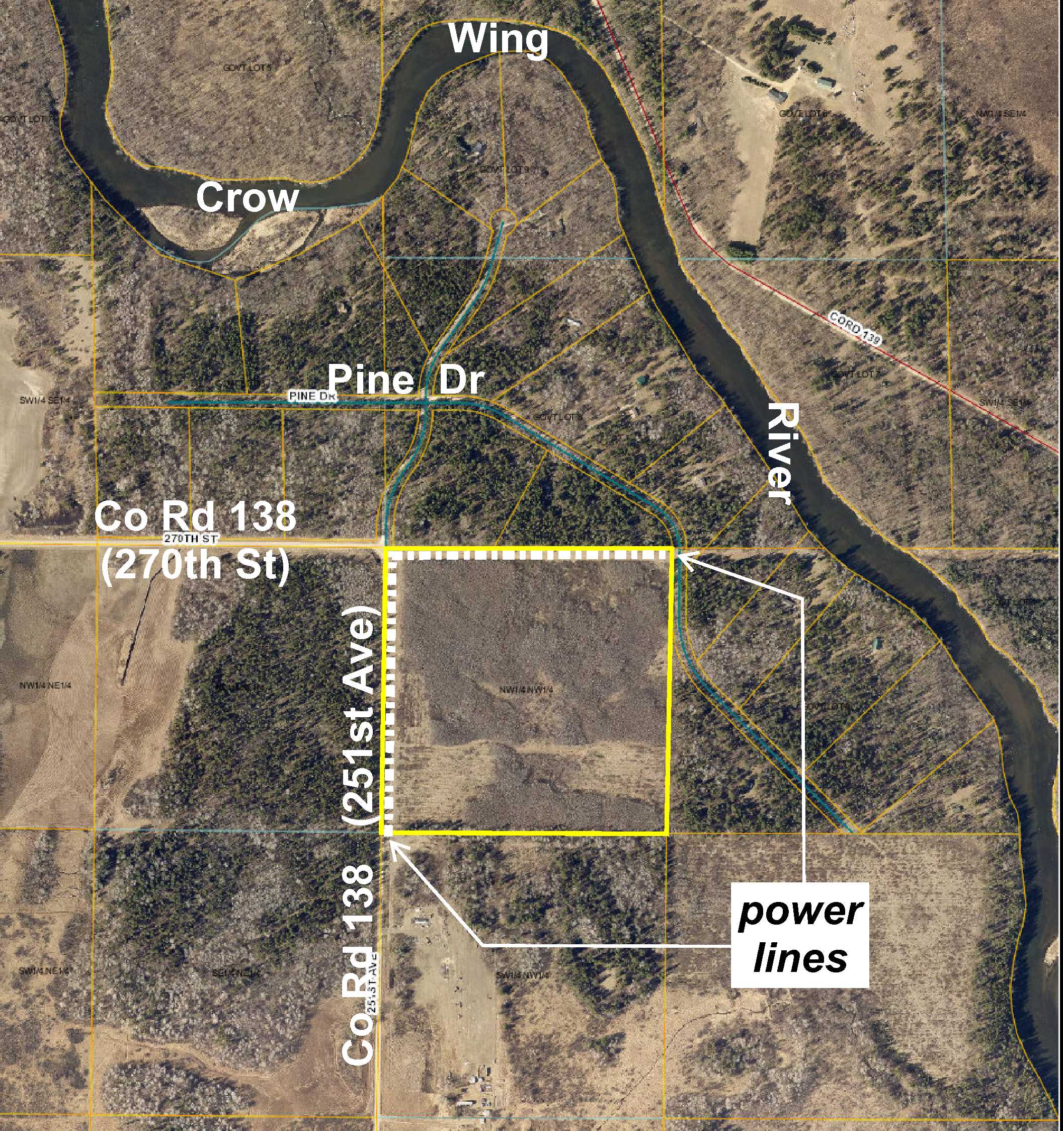
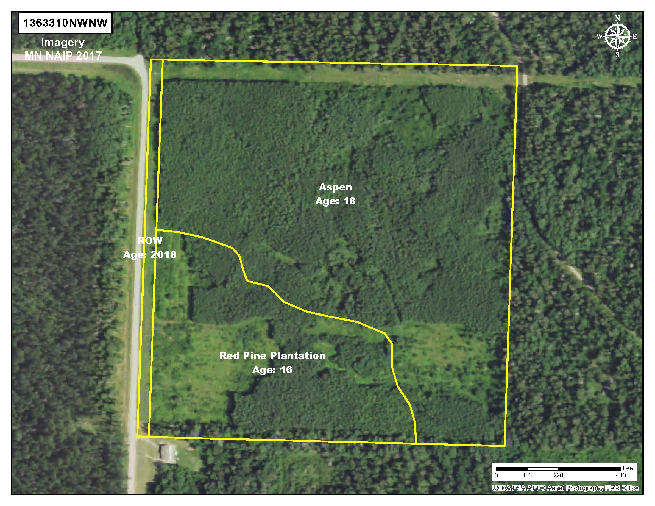
Nice “40” of Potlatch land amidst waterfront parcels on the Crow Wing River south of Nimrod. Level high ground with aspen and red pine plantation. Power lines along the north and west boundaries. Gravel county road access (with a trail entering the property) on the west and gravel township road access along part of the east side. Strike Wildlife Management Area (WMA) is less than 1 mile south for additional deer, bear, small game, forest game birds, and waterfowl hunting options.
Main Property Info
Property ID
060102090
060102090
MLS Number
4720796
4720796
Status
Sold
Sold
List Price
$61,900
$61,900
Selling Price
$54,000
$54,000
Acres
40
40
Zoning
A-2 Mixed Agriculture
A-2 Mixed Agriculture
City
Sebeka
Sebeka
Township
Lyons Twp
Lyons Twp
State
MN
MN
Zip Code
56477
56477
County
Wadena
Wadena
Legal Description
NWNW except railroad and pole right-of-ways, 10-136-33. Subject to power lines and any other easements, restrictions, or reservations of record.
NWNW except railroad and pole right-of-ways, 10-136-33. Subject to power lines and any other easements, restrictions, or reservations of record.
Property Location
Directions
From the intersection of Co Rd 26 and Co Rd 138 (270th St) south of Nimrod, east on Co Rd 138 (270th St) for 2 miles. Right to continue on Co Rd 138 (now 251st Ave) for 2/10 mile to trail on the left leading into the west side of the property.
From the intersection of Co Rd 26 and Co Rd 138 (270th St) south of Nimrod, east on Co Rd 138 (270th St) for 2 miles. Right to continue on Co Rd 138 (now 251st Ave) for 2/10 mile to trail on the left leading into the west side of the property.
Access
Gravel Co Rd 138 (251st Ave) is along the west boundary and a trail provides access to interior areas of the land. Pine Dr, a gravel township road, runs along the north part of the east side for access to that area.
Gravel Co Rd 138 (251st Ave) is along the west boundary and a trail provides access to interior areas of the land. Pine Dr, a gravel township road, runs along the north part of the east side for access to that area.
GPS Coordinates
Coordinates to approximate corners and points based on county mapping: point where trail off Co Rd 138 (251st Ave) enters west side = 46.6128, -94.8431; NW corner (at the corner/intersection of Co Rd 138 (251st Ave & 270th St) and Pine Dr) = 46.6154, -94.8430; NE corner along Pine Dr = 46.6154, -94.8378; SE corner = 46.6118, -94.8379; SW corner along Co Rd 138 (251st Ave) = 46.6118, -94.8430.
Coordinates to approximate corners and points based on county mapping: point where trail off Co Rd 138 (251st Ave) enters west side = 46.6128, -94.8431; NW corner (at the corner/intersection of Co Rd 138 (251st Ave & 270th St) and Pine Dr) = 46.6154, -94.8430; NE corner along Pine Dr = 46.6154, -94.8378; SE corner = 46.6118, -94.8379; SW corner along Co Rd 138 (251st Ave) = 46.6118, -94.8430.
Address
251st Avenue
251st Avenue
School District
Sebeka - 820
Sebeka - 820
Property Details
Dimensions (approx)
1320x1320x1320x1320
1320x1320x1320x1320
Utilities
Power Company
Todd-Wadena Electric (1-800-320-8932)
Todd-Wadena Electric (1-800-320-8932)
Taxes & Fees
Tax Amount
$608
$608
Tax Year
2018
2018
Other Details
Section Number
10
10
Township Number
136
136
Range Number
33
33
Estimated Upland %
99
99
Estimated Wetland %
1
1
Additional Comments
Timber Comments
This property has been managed according to Forest Stewardship Council (FSC) standards. Timber includes aspen and red pine plantation. If timber value is important to you, seek the advice of a competent forester to determine species, volumes and values.
This property has been managed according to Forest Stewardship Council (FSC) standards. Timber includes aspen and red pine plantation. If timber value is important to you, seek the advice of a competent forester to determine species, volumes and values.
Hunting Comments
This property is near public land in MN Firearms Deer Zone 246. Strike WMA less than 1 mile south provides additional deer, bear, small game, forest game birds, and waterfowl hunting options.
This property is near public land in MN Firearms Deer Zone 246. Strike WMA less than 1 mile south provides additional deer, bear, small game, forest game birds, and waterfowl hunting options.
Disclosures
Not surveyed; acreage and dimensions approximate based on county data and mapping; county disclaimers included by reference. Photos/maps for convenience only and not guaranteed; physically inspect prior to purchase. Any deer stands on the land are not property of seller and are not included in sale. Use seller-approved PA and addendum; closing dates the 3rd Wednesday each month.
Not surveyed; acreage and dimensions approximate based on county data and mapping; county disclaimers included by reference. Photos/maps for convenience only and not guaranteed; physically inspect prior to purchase. Any deer stands on the land are not property of seller and are not included in sale. Use seller-approved PA and addendum; closing dates the 3rd Wednesday each month.


