


MLS Number : 4415185
Sold $75,000 - Hunting & Recreation
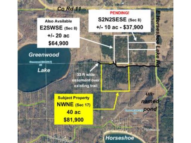
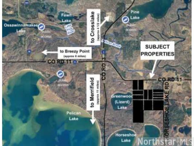
Hilly 40 ac of Potlatch land primarily wooded w/ red pine. Near Greenwood/Lizard, Pelican, Horseshoe, Pine, and Ossawinnamakee Lakes as well as Crow Wing County Memorial Forest & Crow Wing State Forest.
Main Property Info
Property ID
770171200000009
770171200000009
MLS Number
4415185
4415185
Status
Sold
Sold
List Price
$81,900
$81,900
Selling Price
$75,000
$75,000
Acres
40.000
40.000
Zoning
Rural Res 2.5 & Shoreland
Rural Res 2.5 & Shoreland
City
Merrifield
Merrifield
Township
Mission Township
Mission Township
State
MN
MN
Zip Code
56465
56465
County
Crow Wing
Crow Wing
Legal Description
NWNE, 17-136-27. Together with 33-ft wide easement over existing trail through NENE. Subject to 33-ft wide easements over existing trail providing access to NENW, 17-136-27 and E1/2SWSE, W1/2SWSE, and S1/2SESW, 8-136-27. Subject to any other easements, restrictions, or reservations of record.
NWNE, 17-136-27. Together with 33-ft wide easement over existing trail through NENE. Subject to 33-ft wide easements over existing trail providing access to NENW, 17-136-27 and E1/2SWSE, W1/2SWSE, and S1/2SESW, 8-136-27. Subject to any other easements, restrictions, or reservations of record.
Property Location
Directions
From Brainerd, N & E on CR 3 to intersect w/CR 11. E on CR 11 approx 1 1/2 mi. S on E Horseshoe Lake Rd approx 1/2 mi. W on easement trl approx 1/4 mi into E side of subject tract.
From Brainerd, N & E on CR 3 to intersect w/CR 11. E on CR 11 approx 1 1/2 mi. S on E Horseshoe Lake Rd approx 1/2 mi. W on easement trl approx 1/4 mi into E side of subject tract.
Access
The property is accessed via an easement over existing trail off E Horseshoe Lake Rd through adjoining land to the east (NENE).
The property is accessed via an easement over existing trail off E Horseshoe Lake Rd through adjoining land to the east (NENE).
GPS Coordinates
Coordinates to approximate corners/points based on county mapping: Point where the trail enters the east side of the property near the NE corner = 46.6019, -94.1052; NE corner = 46.6025, -94.1052; SE corner = 46.5988, -94.1052; SW corner = 46.5988, -94.1105; point where trail exits west side of property near the NW corner = 46.6025, -94.1105; NW corner = 46.6025, -94.1105
Coordinates to approximate corners/points based on county mapping: Point where the trail enters the east side of the property near the NE corner = 46.6019, -94.1052; NE corner = 46.6025, -94.1052; SE corner = 46.5988, -94.1052; SW corner = 46.5988, -94.1105; point where trail exits west side of property near the NW corner = 46.6025, -94.1105; NW corner = 46.6025, -94.1105
Address
NWNE E Horseshoe Lake Road
NWNE E Horseshoe Lake Road
School District
Crosby-Ironton - 182
Crosby-Ironton - 182
Property Details
Dimensions (approx)
1320x1320x1320x1320
1320x1320x1320x1320
Utilities
Available Utilities
Electric
Electric
On Site Utilities
None
None
Power Company
Crow Wing Power (1-800-648-9401)
Crow Wing Power (1-800-648-9401)
Taxes & Fees
Association Fee
$0
$0
Tax Amount
$516
$516
Tax With Assessments
$516
$516
Tax Year
2015
2015
Other Details
Section Number
17
17
Township Number
136
136
Range Number
27
27
Estimated Upland %
99
99
Estimated Wetland %
1
1
Additional Comments
Timber Comments
This property has been managed according to Forest Stewardship Council (FSC) standards and is mostly wooded with red pine. There is also a patch of aspen regeneration in the southeast corner and some jack pine along the west side. If timber value is important to you, seek the advice of a competent forester to determine species, volumes and values.
This property has been managed according to Forest Stewardship Council (FSC) standards and is mostly wooded with red pine. There is also a patch of aspen regeneration in the southeast corner and some jack pine along the west side. If timber value is important to you, seek the advice of a competent forester to determine species, volumes and values.
Hunting Comments
Whitetail deer, rabbits, squirrels, grouse, geese, and ducks are plentiful in this area. The tract is near public land in MN firearms deer zone 247.
Whitetail deer, rabbits, squirrels, grouse, geese, and ducks are plentiful in this area. The tract is near public land in MN firearms deer zone 247.
Disclosures
Not surveyed; acreage and dimensions approximate based on county data and mapping; county disclaimers included by reference. Photos/maps for convenience only and not guaranteed; tree cover may be different than depicted; physically inspect prior to purchase. Any deer stands on the land are not property of seller and are not included in sale. Use seller-approved PA and addendum; closing dates the 2nd Wednesday each month.
Not surveyed; acreage and dimensions approximate based on county data and mapping; county disclaimers included by reference. Photos/maps for convenience only and not guaranteed; tree cover may be different than depicted; physically inspect prior to purchase. Any deer stands on the land are not property of seller and are not included in sale. Use seller-approved PA and addendum; closing dates the 2nd Wednesday each month.


