
MLS Number : 4750792
Sold $109,000 - Hunting & Recreation
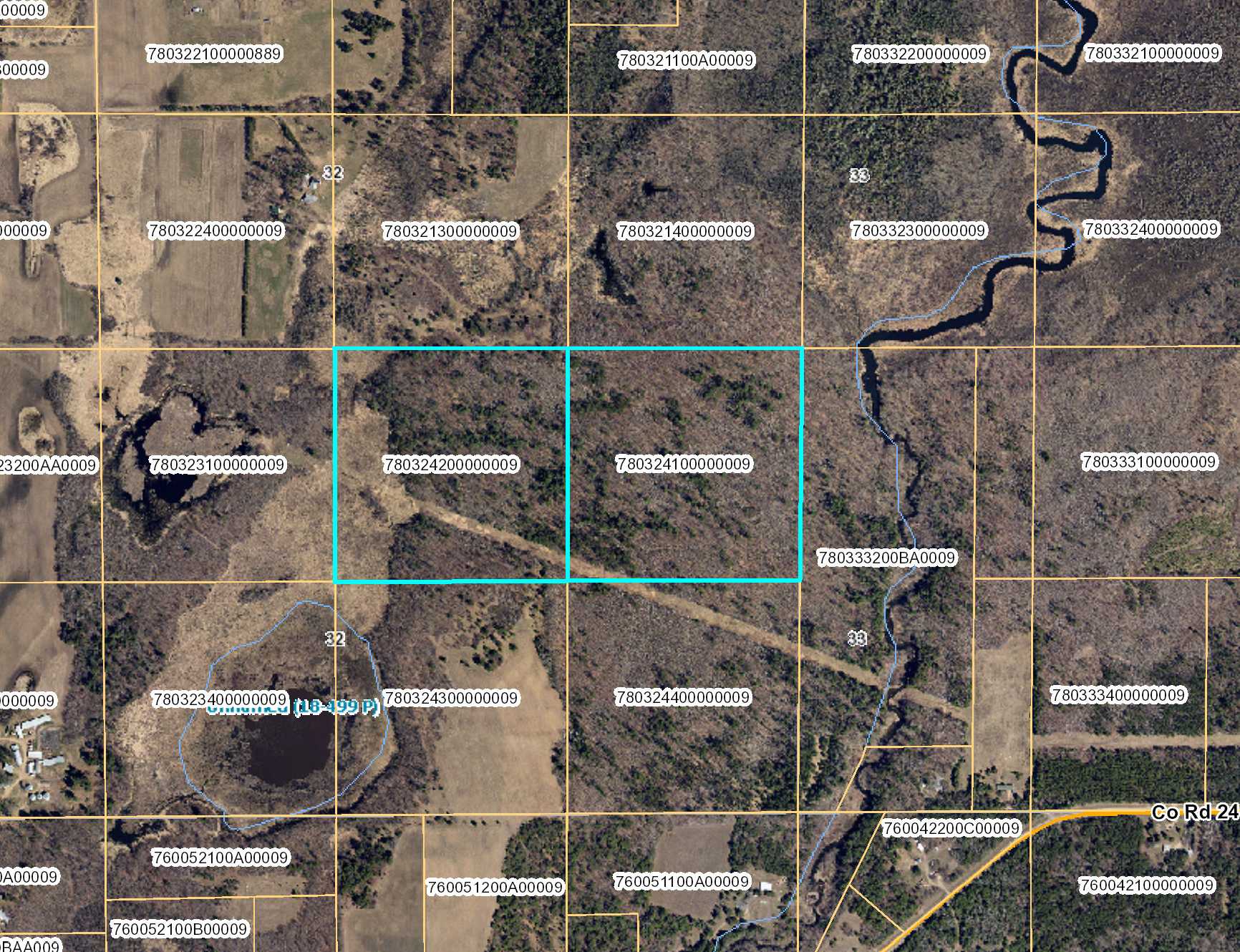
Potlatch land by the Nokasippi River east of Brainerd. Gently-rolling to sloped high ground with wetland along the west side. Adjoins public Crow Wing County Memorial Forest land. There is no legal access to this property; buyer responsible for securing easement(s) for access.
Main Property Info
Property ID
780324100000009 & 780324200000009
780324100000009 & 780324200000009
MLS Number
4750792
4750792
Status
Sold
Sold
List Price
$105,900
$105,900
Selling Price
$109,000
$109,000
Acres
80
80
Zoning
Agricultural/Forestry District
Agricultural/Forestry District
City
Brainerd
Brainerd
Township
First Assessment Twp
First Assessment Twp
State
MN
MN
Zip Code
56401
56401
County
Crow Wing
Crow Wing
Legal Description
NESE & NWSE, 32-045-29. Subject to any easements, restrictions, or reservations of record.
NESE & NWSE, 32-045-29. Subject to any easements, restrictions, or reservations of record.
Property Location
Directions
From the intersection of Co Rd 18 and Co Rd 8 SE/Pine Center Rd east of Brainerd, south on Co Rd 8 SE/Pine Center Rd for 1 2/10 miles. Right on Co Rd 24 SE for 1 2/10 miles. Property is approx 3/10 mile north through privately-owned land.
From the intersection of Co Rd 18 and Co Rd 8 SE/Pine Center Rd east of Brainerd, south on Co Rd 8 SE/Pine Center Rd for 1 2/10 miles. Right on Co Rd 24 SE for 1 2/10 miles. Property is approx 3/10 mile north through privately-owned land.
Access
There is no legal access to this property. Buyer is responsible for securing easement(s) for access.
There is no legal access to this property. Buyer is responsible for securing easement(s) for access.
GPS Coordinates
Coordinates to approximate corners/points based on county mapping: NW corner = 46.3375, -94.0312; NE corner = 46.3374, -94.0207; SE corner = 46.3338, -94.0208; SW corner = 46.3338, -94.0312.
Coordinates to approximate corners/points based on county mapping: NW corner = 46.3375, -94.0312; NE corner = 46.3374, -94.0207; SE corner = 46.3338, -94.0208; SW corner = 46.3338, -94.0312.
Address
NESE&NWSE County Road 24
NESE&NWSE County Road 24
School District
Brainerd - 181
Brainerd - 181
Property Details
Dimensions (approx)
2640 x 1320 x 2640 x 1320
2640 x 1320 x 2640 x 1320
Utilities
Power Company
Crow Wing Power (1-800-648-9401)
Crow Wing Power (1-800-648-9401)
Taxes & Fees
Tax Amount
$1,174
$1,174
Assessment Amount
0
0
Tax With Assessments
$1,174
$1,174
Tax Year
2016
2016
Other Details
Section Number
32
32
Township Number
45
45
Range Number
29
29
Estimated Upland %
75
75
Estimated Wetland %
25
25
Additional Comments
Timber Comments
This property has been managed according to Forest Stewardship Council (FSC) standards. If timber value is important to you, seek the advice of a competent forester to determine species, volumes and values.
This property has been managed according to Forest Stewardship Council (FSC) standards. If timber value is important to you, seek the advice of a competent forester to determine species, volumes and values.
Disclosures
No access; buyer responsible for securing easement(s) for access. Not surveyed; acreage/dimensions approx based on county data/mapping; disclaimers incl by reference. GPS coordinates to approx corners available from listing agent. Photos/maps not guaranteed; inspect prop prior to purchase. Use seller-approved PA & addm; closing 2nd Wed each month.
No access; buyer responsible for securing easement(s) for access. Not surveyed; acreage/dimensions approx based on county data/mapping; disclaimers incl by reference. GPS coordinates to approx corners available from listing agent. Photos/maps not guaranteed; inspect prop prior to purchase. Use seller-approved PA & addm; closing 2nd Wed each month.


