


MLS Number : 4528493
Sold $80,000 - Hunting & Recreation, Price Reduced
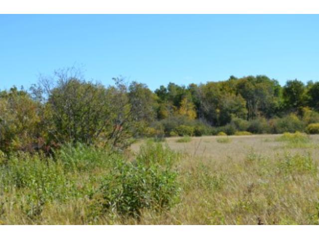
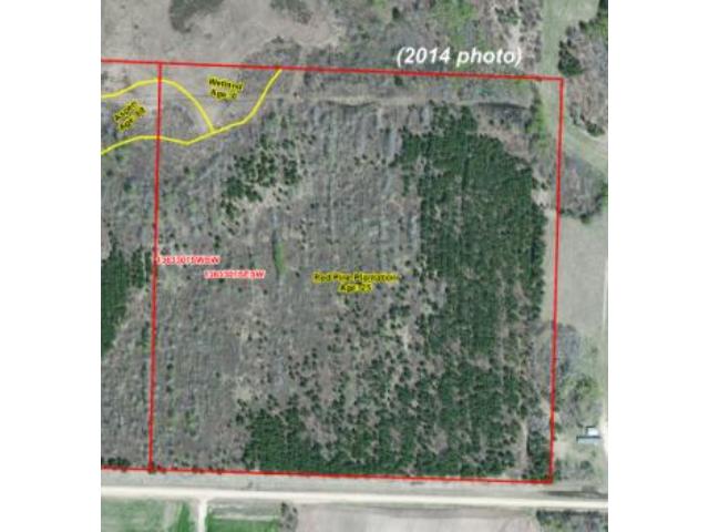
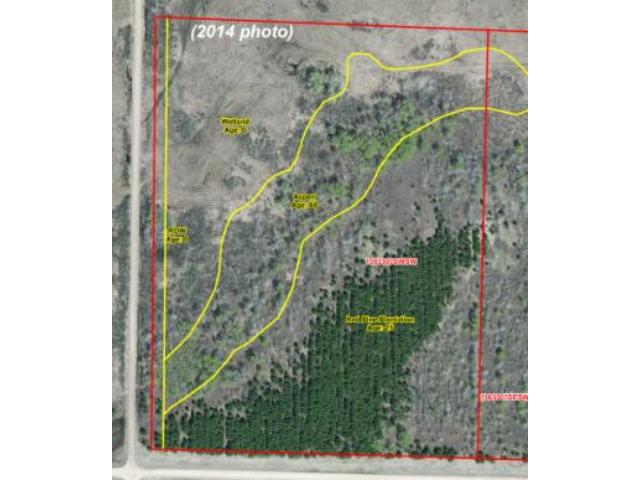
Price lowered from $97,900 to $85,500! Prime Potlatch hunting land near Crow Wing River and Strike Wildlife Management Area by Nimrod. Level upland covered in red pine bordered by an arch of aspen along a wetland area in the northwest corner. County and township road access.
Main Property Info
Property ID
060073020
060073020
MLS Number
4528493
4528493
Status
Sold
Sold
List Price
$85,500
$85,500
Selling Price
$80,000
$80,000
Acres
70.5
70.5
Zoning
A-2 Mixed Ag
A-2 Mixed Ag
City
Sebeka
Sebeka
Township
Lyons Twp
Lyons Twp
State
MN
MN
Zip Code
56477
56477
County
Wadena
Wadena
Legal Description
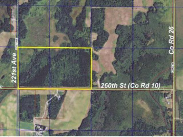
GL4(SWSW) & SESW, 7-136-33. Subject to 260th St (Co Rd 10) and 221st Ave. Subject to any easements, restrictions, or reservations of record.
GL4(SWSW) & SESW, 7-136-33. Subject to 260th St (Co Rd 10) and 221st Ave. Subject to any easements, restrictions, or reservations of record.
Property Location
Directions
From the intersection of State Hwy 227 (Co Rd 12) and Co Rd 26 in Nimrod, south on Co Rd 26 for approx 2 miles. Right(west) on 260th St (Co Rd 10) for 1/2 mile to southeast corner.
From the intersection of State Hwy 227 (Co Rd 12) and Co Rd 26 in Nimrod, south on Co Rd 26 for approx 2 miles. Right(west) on 260th St (Co Rd 10) for 1/2 mile to southeast corner.
Access
The property adjoins unpaved 260th St (Co Rd 10) along the entire south side and unpaved 221st Ave along the entire west side.
The property adjoins unpaved 260th St (Co Rd 10) along the entire south side and unpaved 221st Ave along the entire west side.
GPS Coordinates
Coordinates to approximate corners/points based on county mapping: Approx SE corner of the property along 260th St (Co Rd 10)=46.6010, -94.8956 Approx SW corner at intersection of 260th St (Co Rd 10)and 221st Ave=46.6010, -94.9049 Approx NW corner along 221st Ave=46.6047, -94.9050 Approx NE corner=46.6047, -94.8957
Coordinates to approximate corners/points based on county mapping: Approx SE corner of the property along 260th St (Co Rd 10)=46.6010, -94.8956 Approx SW corner at intersection of 260th St (Co Rd 10)and 221st Ave=46.6010, -94.9049 Approx NW corner along 221st Ave=46.6047, -94.9050 Approx NE corner=46.6047, -94.8957
Address
GL4&SESW 260th Street
GL4&SESW 260th Street
School District
Sebeka - 820
Sebeka - 820
Property Details
Dimensions (approx)
2330x2330x1320x1320
2330x2330x1320x1320
Utilities
Available Utilities
None
None
On Site Utilities
None
None
Power Company
Todd-Wadena Electric (1-800-320-8932)
Todd-Wadena Electric (1-800-320-8932)
Taxes & Fees
Association Fee
$0
$0
Tax Amount
$812
$812
Assessment Amount
0
0
Tax With Assessments
$812
$812
Tax Year
2017
2017
Other Details
Section Number
7
7
Township Number
136
136
Range Number
33
33
Estimated Upland %
90
90
Estimated Wetland %
10
10
Additional Comments
Timber Comments
This property has been managed according to Forest Stewardship Council (FSC) standards. It is wooded with Red Pine plantation and Aspen, part of which has been harvested and replanted. If timber value is important to you, seek the advice of a competent forester to determine species, volumes and values.
This property has been managed according to Forest Stewardship Council (FSC) standards. It is wooded with Red Pine plantation and Aspen, part of which has been harvested and replanted. If timber value is important to you, seek the advice of a competent forester to determine species, volumes and values.
Hunting Comments
This property is near public land in MN firearms deer zone 246. With the Crow Wing River and Strike Lake State Wildlife Management Area to the east, this is a popular destination for hunting whitetail deer, upland birds, and small game.
This property is near public land in MN firearms deer zone 246. With the Crow Wing River and Strike Lake State Wildlife Management Area to the east, this is a popular destination for hunting whitetail deer, upland birds, and small game.
Disclosures
Not surveyed; acreage and dimensions approximate based on county data and mapping; county disclaimers included by reference. Photos/maps for convenience only and not guaranteed; physically inspect prior to purchase. Any deer stands on the land are not property of seller and are not included in sale. Use seller-approved PA and addendum; closing dates the 3rd Wednesday each month.
Not surveyed; acreage and dimensions approximate based on county data and mapping; county disclaimers included by reference. Photos/maps for convenience only and not guaranteed; physically inspect prior to purchase. Any deer stands on the land are not property of seller and are not included in sale. Use seller-approved PA and addendum; closing dates the 3rd Wednesday each month.


