

MLS Number : 5328319
Sold $140,000 - Home & Cabin Sites, Hunting & Recreation
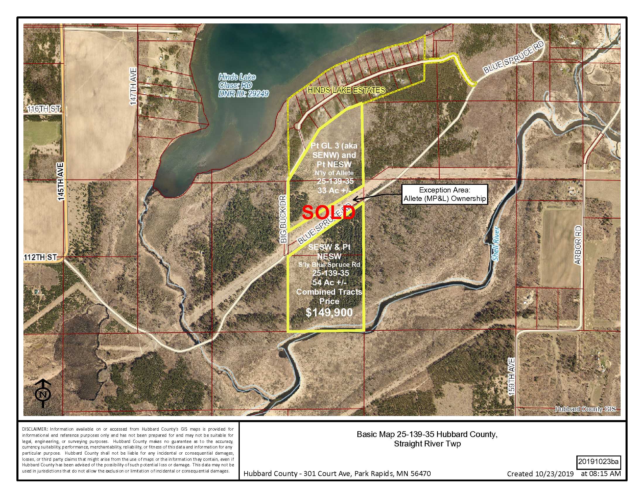
Well located 87+/- acres near Hinds Lake between Park Rapids and Menahga. This generally level/gently rolling property is predominantly wooded with a mature aspen and red pine plantation. Close to Hinds Lake and Long Lake public accesses and Blueberry Pines Golf Course. The neighborhood has homes on and off of Hinds Lake.
Main Property Info
Property ID
25.25.00800, 25.25.01200, 25.25.01100
25.25.00800, 25.25.01200, 25.25.01100
MLS Number
5328319
5328319
Status
Sold
Sold
List Price
$149,900
$149,900
Selling Price
$140,000
$140,000
Acres
87
87
Zoning
Shoreland & Forested River
Shoreland & Forested River
City
Menahga
Menahga
Township
Straight River Twp
Straight River Twp
State
MN
MN
Zip Code
56464
56464
County
Hubbard
Hubbard
Legal Description
See Exhibit A. Pt GL3 (SENW), Pt NESW, SESW, 25-139-35. Subject to easements, restrictions and reservations of record.
See Exhibit A. Pt GL3 (SENW), Pt NESW, SESW, 25-139-35. Subject to easements, restrictions and reservations of record.
Property Location
Directions
From Park Rapids at intersection of State Hwy 34 and State Hwy 71; South on Hwy 71 for 7 miles to 110th Street; East on 110th & 112th Streets 1.3 miles to Blue Spruce Road; turn Southeasterly on Blue Spruce Road for 1 mile to Intersection of Big Buck Drive. (Tracts lie Northerly & Southerly of the Powerline Easement.)
From Park Rapids at intersection of State Hwy 34 and State Hwy 71; South on Hwy 71 for 7 miles to 110th Street; East on 110th & 112th Streets 1.3 miles to Blue Spruce Road; turn Southeasterly on Blue Spruce Road for 1 mile to Intersection of Big Buck Drive. (Tracts lie Northerly & Southerly of the Powerline Easement.)
Access
Blue Spruce Road and Big Buck Drive are township maintained, gravel roads.
Blue Spruce Road and Big Buck Drive are township maintained, gravel roads.
GPS Coordinates
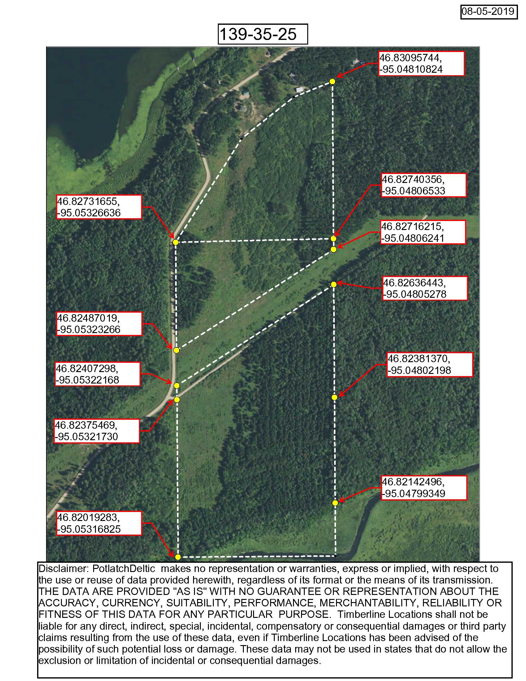
Coordinates to approximate corners/points based on county mapping: NW: 46.8273, -95.0532 NE: 46.8309, -95.0481 SE: 46.8214, -95.0479 SW: 46.8201, -95.0531
Coordinates to approximate corners/points based on county mapping: NW: 46.8273, -95.0532 NE: 46.8309, -95.0481 SE: 46.8214, -95.0479 SW: 46.8201, -95.0531
Address
TBD PtGL3 (SENW), PtNESW, SESW, Big Buck Dr, Menahga, MN 56464
TBD PtGL3 (SENW), PtNESW, SESW, Big Buck Dr, Menahga, MN 56464
School District
Menahga - 82
Menahga - 82
Property Details
Pasture Acres
N/A
N/A
Tillable Acres
N/A
N/A
Wooded Acres
78
78
Dimensions (approx)
Irregular 1914 x 3663 x 1320 x 3663
Irregular 1914 x 3663 x 1320 x 3663
Utilities
Available Utilities
Electric, Telephone
Electric, Telephone
On Site Utilities
None
None
Power Company
Itasca-Mantrap Co-op (1-888-713-3377)
Itasca-Mantrap Co-op (1-888-713-3377)
Waterfront
Waterfront Name
None
None
Waterfront Number
None
None
Waterfront Feet (approx)
None
None
Taxes & Fees
Has Association Fee
No
No
Association Fee
$0
$0
Association Fee Includes
0
0
Tax Amount
$1,310
$1,310
Assessment Amount
0
0
Tax With Assessments
$1,310
$1,310
Assessment Pending
No
No
Assessment Description
N/A
N/A
Tax Year
2019
2019
Other Details
Section Number
25
25
Township Number
139
139
Range Number
35
35
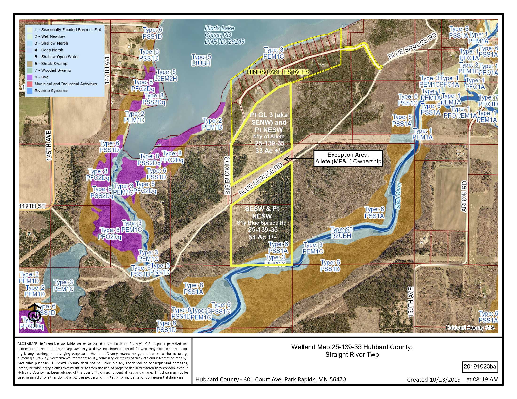
Estimated Upland %
91
91
Estimated Wetland %
9
9
Additional Comments
Timber Comments
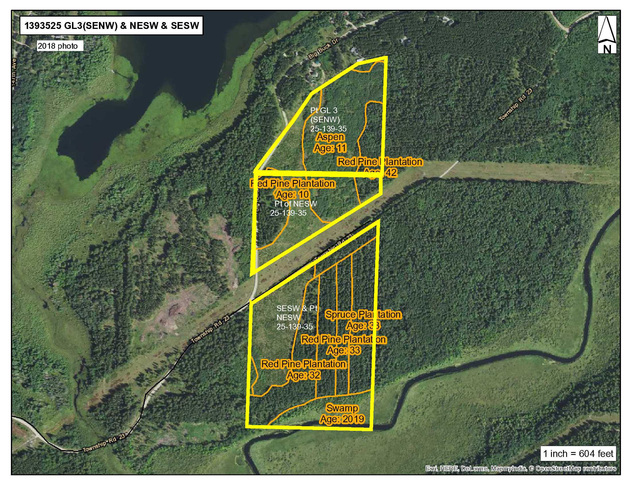
Red Pine 10 and 42 years old; Spruce 10 years old; Aspen 11 years old. This property has been managed according to Forest Stewardship Council (FSC) standards. If Timber value is important to you, seek the advice of a competent forester to determine species, volumes and values.
Red Pine 10 and 42 years old; Spruce 10 years old; Aspen 11 years old. This property has been managed according to Forest Stewardship Council (FSC) standards. If Timber value is important to you, seek the advice of a competent forester to determine species, volumes and values.
Hunting Comments
Deer Permit Area: 241
Deer Permit Area: 241
Disclosures
Approximate corners have been flagged. As indicated in the maps and legal description, there is an exception area owned by Allete (MP&L) PID#25.25.00400 lying centrally through the tract/s that is not included with this sale. Acreage, dimensions, and taxes estimated based on county data and mapping or seller data; county disclaimers included by reference; subject to split approval if necessary. Not surveyed. Photos/maps and GPS coordinates for convenience only and not guaranteed; physically inspect prior to purchase. Any deer stands on the land are not property of seller and are not included in sale. Use seller-approved PA and addendum; closing dates the 3rd Wednesday each month. Seller is Potlatch MN Timberlands LLC, a business entity under the laws of the State of Delaware.
Approximate corners have been flagged. As indicated in the maps and legal description, there is an exception area owned by Allete (MP&L) PID#25.25.00400 lying centrally through the tract/s that is not included with this sale. Acreage, dimensions, and taxes estimated based on county data and mapping or seller data; county disclaimers included by reference; subject to split approval if necessary. Not surveyed. Photos/maps and GPS coordinates for convenience only and not guaranteed; physically inspect prior to purchase. Any deer stands on the land are not property of seller and are not included in sale. Use seller-approved PA and addendum; closing dates the 3rd Wednesday each month. Seller is Potlatch MN Timberlands LLC, a business entity under the laws of the State of Delaware.


