
MLS Number : 5262103
Sold $115,000 - Home & Cabin Sites, Hunting & Recreation
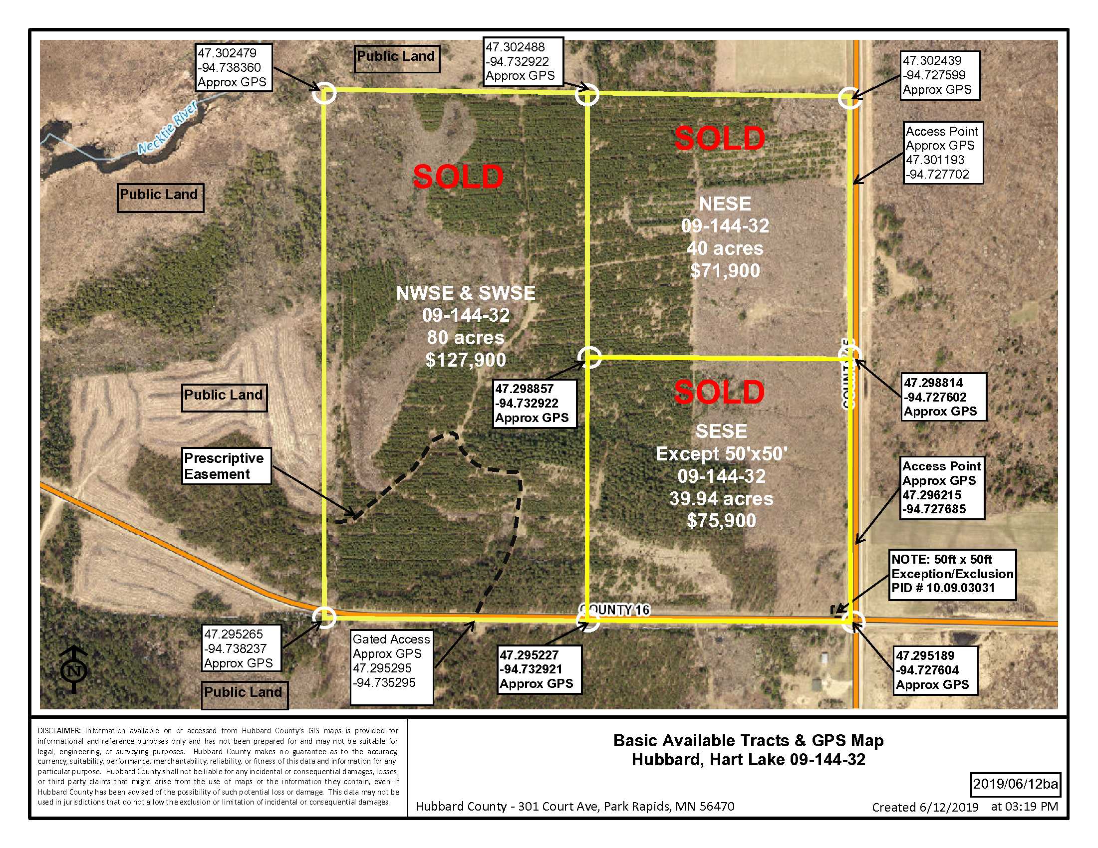
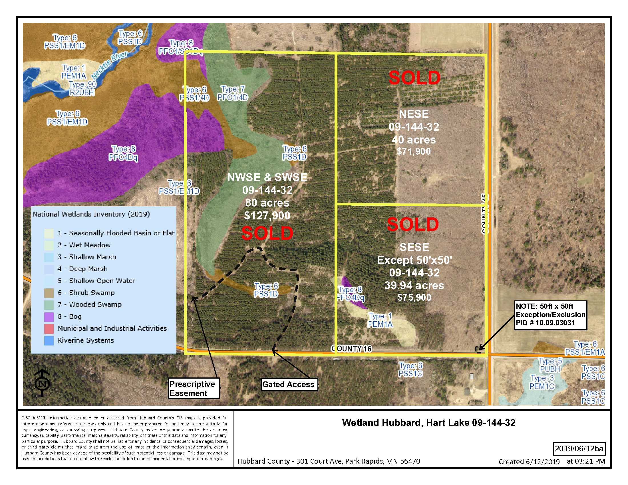
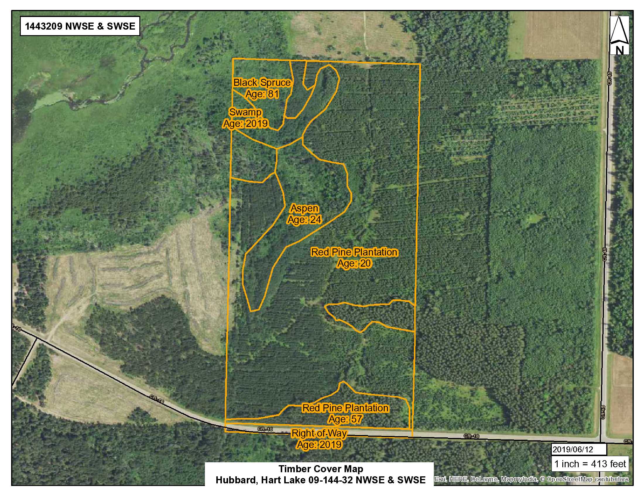
This 80 acre PotlatchDeltic tract is centrally located within the Walker/Bemidji lake/recreational areas! The rolling topography tract boasts over 55 acres of mature trees including red pine, black spruce and aspen ranging from 20 to 81 years in age. This tract adjoins public land on its’ entire north & west sides and would make a great hunting/recreational and/or potential home site all within a short drive to shopping, dining and lake area recreation. Property access off paved County Road 16. Additional land available. Located in Bemidji School District.
Main Property Info
Property ID
PID 10.09.00600 & PID 10.09.00700
PID 10.09.00600 & PID 10.09.00700
MLS Number
5262103
5262103
Status
Sold
Sold
List Price
$127,900
$127,900
Selling Price
$115,000
$115,000
Acres
80
80
Zoning
N/A
N/A
City
Laporte
Laporte
Township
Hart Lake Twp
Hart Lake Twp
State
MN
MN
Zip Code
56461
56461
County
Hubbard
Hubbard
Legal Description
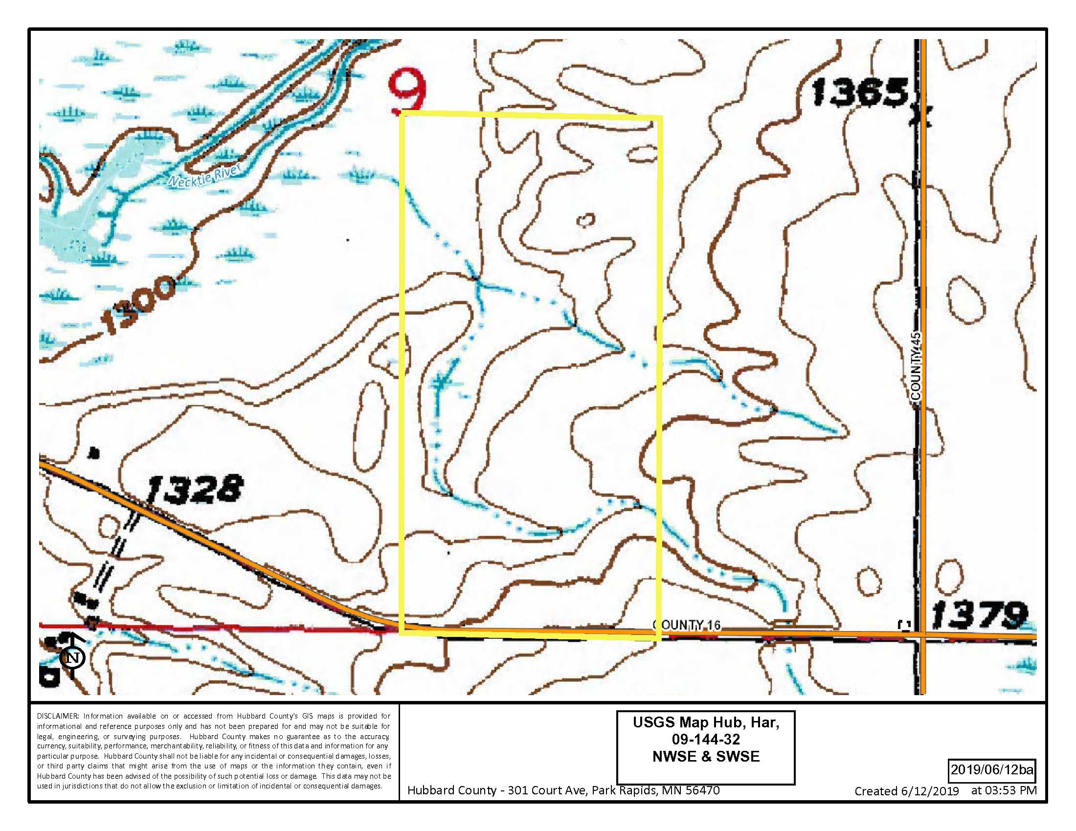
NWSE & SWSE, 09-144-32, Hubbard County, Minnesota. Subject to prescriptive easement and restrictions or reservations of record.
NWSE & SWSE, 09-144-32, Hubbard County, Minnesota. Subject to prescriptive easement and restrictions or reservations of record.
Property Location
Directions
4 miles northwest of Walker at the intersection of Hwy 371 and Hwy 200, continue north on Hwy 371 for 10.6 miles. Turn left (west) onto 136th St. NW (Co Rd 21) and drive 1.9 miles. Continue west onto Co Rd 16 and drive 3.4 miles to property access point on the right (north). Approx GPS Lat: 47.295295, Lon: -94.735295.
4 miles northwest of Walker at the intersection of Hwy 371 and Hwy 200, continue north on Hwy 371 for 10.6 miles. Turn left (west) onto 136th St. NW (Co Rd 21) and drive 1.9 miles. Continue west onto Co Rd 16 and drive 3.4 miles to property access point on the right (north). Approx GPS Lat: 47.295295, Lon: -94.735295.
Access
Gated Access off Co Rd 16. Approx GPS Point Lat: 47.295295, Lon: -94.735295.
Gated Access off Co Rd 16. Approx GPS Point Lat: 47.295295, Lon: -94.735295.
GPS Coordinates
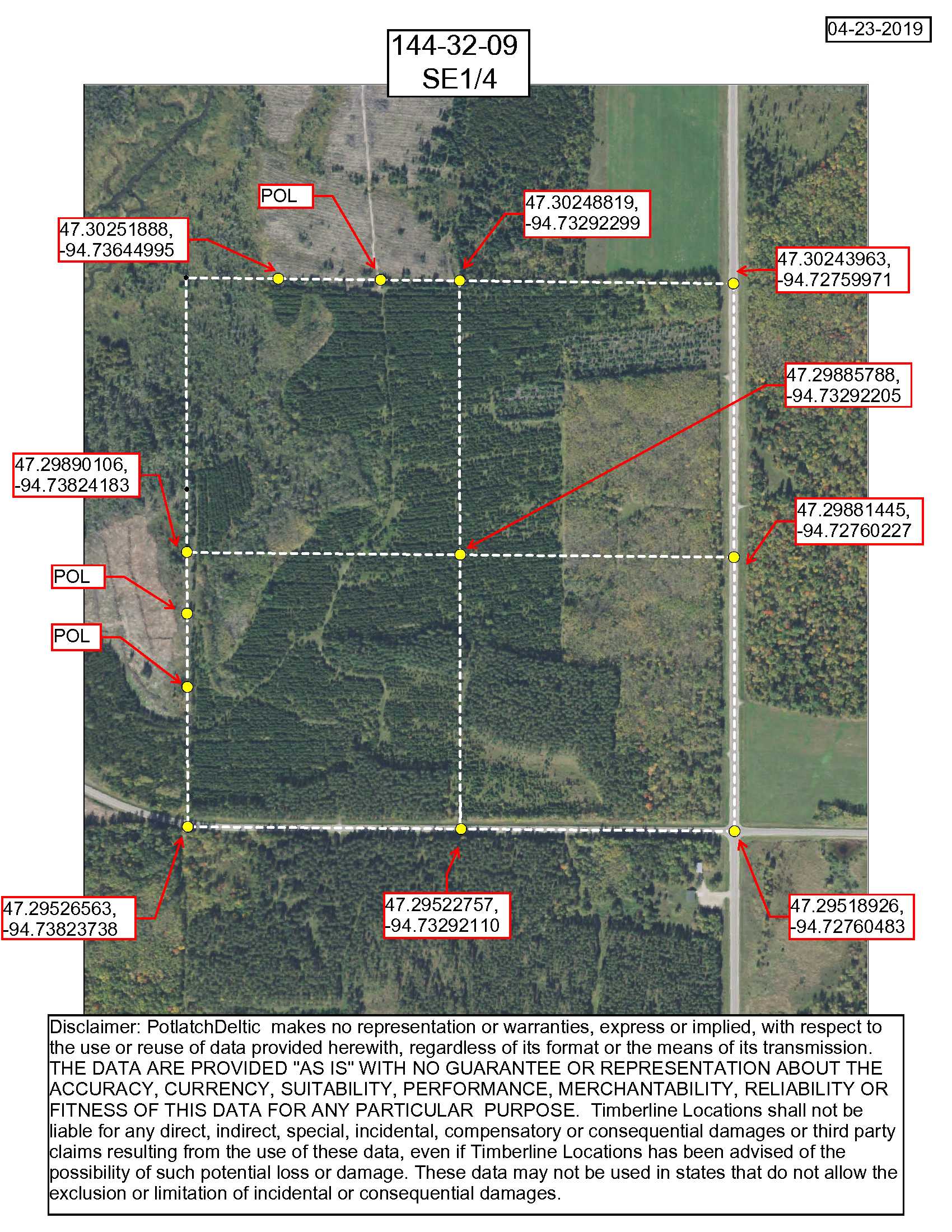
Coordinates to approximate corners/points based on county mapping: NW: 47.302479, -94.738360 NE: 47.302488, -94.732922 SE: 47.295227, -94.732921 SW: 47.295265, -94.738237
Coordinates to approximate corners/points based on county mapping: NW: 47.302479, -94.738360 NE: 47.302488, -94.732922 SE: 47.295227, -94.732921 SW: 47.295265, -94.738237
Address
TBD, Co Rd 16, Laporte MN. 56461
TBD, Co Rd 16, Laporte MN. 56461
School District
Bemidji - 31
Bemidji - 31
Property Details
Pasture Acres
0
0
Wooded Acres
55
55
Dimensions (approx)
1320 x 2640 x 1320 x 2640
1320 x 2640 x 1320 x 2640
Utilities
Available Utilities
Electric
Electric
On Site Utilities
None
None
Power Company
Beltrami Electric (1-800-955-6083)
Beltrami Electric (1-800-955-6083)
Waterfront
Waterfront Name
N/A
N/A
Waterfront Number
N/A
N/A
Waterfront Feet (approx)
N/A
N/A
Waterfront Comments
N/A
N/A
Taxes & Fees
Has Association Fee
No
No
Association Fee
$0
$0
Association Fee Includes
N/A
N/A
Tax Amount
$792
$792
Assessment Amount
0
0
Tax With Assessments
$792
$792
Assessment Pending
No
No
Assessment Description
N/A
N/A
Tax Year
2019
2019
Other Details
Section Number
09
09
Township Number
144
144
Range Number
32
32
Estimated Upland %
74
74
Estimated Wetland %
26
26
Additional Comments
Timber Comments
Red Pine Age 20-57 yrs., Black Spruce Age 81 yrs., Aspen Age 24 yrs.
Red Pine Age 20-57 yrs., Black Spruce Age 81 yrs., Aspen Age 24 yrs.
Hunting Comments
Red Pine Age 20-57 yrs., Black Spruce Age 81 yrs., Aspen Age 24 yrs. Deer Permit Area: 284
Red Pine Age 20-57 yrs., Black Spruce Age 81 yrs., Aspen Age 24 yrs. Deer Permit Area: 284
Disclosures
Easement(s) affect this property. See legal description and maps for details. There is a prescriptive easement that runs through the lower southwest corner of the tract. Acreage, dimensions, and taxes estimated based on county data and mapping or seller data; county disclaimers included by reference; subject to split approval if necessary. Not surveyed. Photos/maps and GPS coordinates for convenience only and not guaranteed; physically inspect prior to purchase. Any deer stands on the land are not property of seller and are not included in sale. Use seller-approved PA and addendum; closing dates the 3rd Wednesday each month.
Easement(s) affect this property. See legal description and maps for details. There is a prescriptive easement that runs through the lower southwest corner of the tract. Acreage, dimensions, and taxes estimated based on county data and mapping or seller data; county disclaimers included by reference; subject to split approval if necessary. Not surveyed. Photos/maps and GPS coordinates for convenience only and not guaranteed; physically inspect prior to purchase. Any deer stands on the land are not property of seller and are not included in sale. Use seller-approved PA and addendum; closing dates the 3rd Wednesday each month.


