


MLS Number : 5137337
Sold $109,900 - Hunting & Recreation
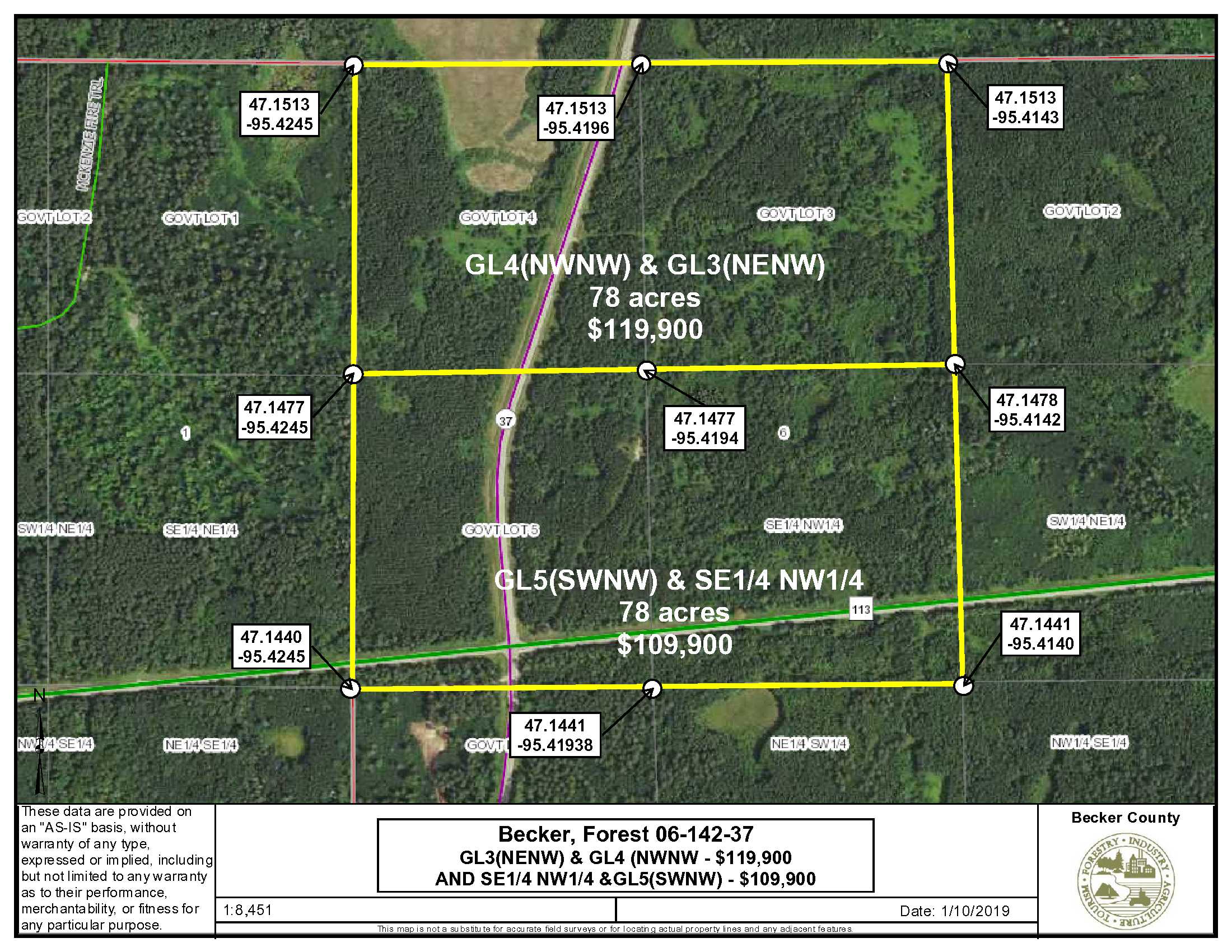
Near Itasca State Park and many lakes and trails in Becker County. Whitetail and upland bird hunting, plus it’s close to snowmobile trails and the North Country Trail. Mostly upland with rolling topography and a few small low areas. PotlatchDeltic land; tree cover is red pine plantation and aspen. It’s 6 miles from Itasca State Park and less than 2 miles to the Bad Medicine Lake access. The Bad Medicine Lake Campground is also nearby. Other lakes are in the area, including Long, Juggler, Pickerel, Elbow and others. Another 78 acre parcel adjoins this tract on the north MLS # 5137162
Main Property Info
Property ID
Part of PID# R120041010
Part of PID# R120041010
MLS Number
5137337
5137337
Status
Sold
Sold
List Price
$109,900
$109,900
Selling Price
$109,900
$109,900
Acres
78
78
Zoning
Agriculture
Agriculture
City
Elbow Lake
Elbow Lake
Township
Forest Twp
Forest Twp
State
MN
MN
Zip Code
56531
56531
County
Becker
Becker
Legal Description
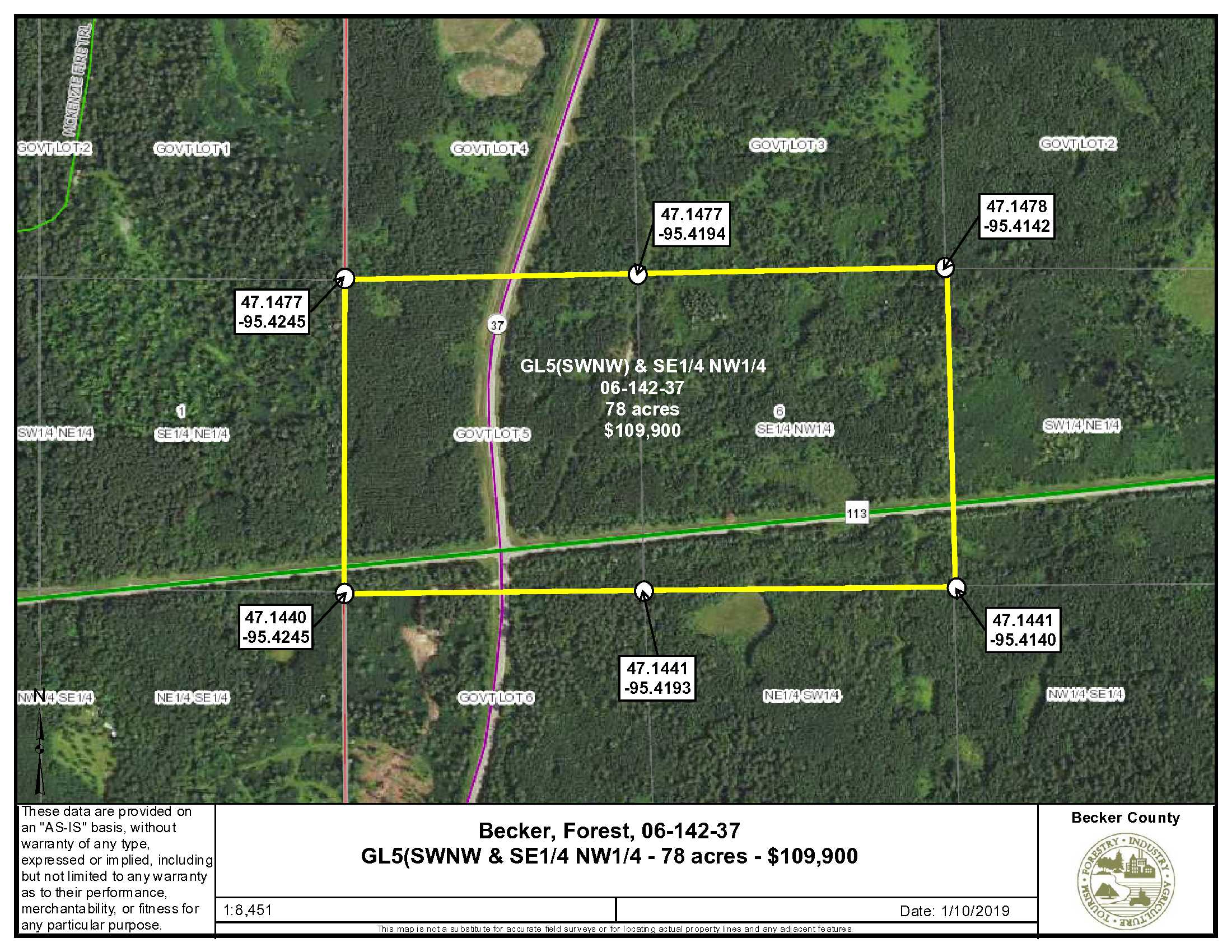
GL5 (also known as SWNW) and SENW, 6-142-37, subject to Co Rd 113 and Co Rd 37 (aka Lost Lake Rd) and subject to easements, restrictions and reservations of record, if any.
GL5 (also known as SWNW) and SENW, 6-142-37, subject to Co Rd 113 and Co Rd 37 (aka Lost Lake Rd) and subject to easements, restrictions and reservations of record, if any.
Property Location
Directions
From Park Rapids, intersection of Hwy 34 and Hwy 71; North on Hwy 71 17.3 miles; West on Co Rd 113 13.5 miles to the intersection of Co Rd 113 and Co Rd 37 (Long Lost Lake Road); this intersection is in the SW quadrant of the tract. See map.
From Park Rapids, intersection of Hwy 34 and Hwy 71; North on Hwy 71 17.3 miles; West on Co Rd 113 13.5 miles to the intersection of Co Rd 113 and Co Rd 37 (Long Lost Lake Road); this intersection is in the SW quadrant of the tract. See map.
Access
Access is via Co Rd 113 or Co Rd 37, however there does not appear to be approaches into the property from either road. Contact Becker County regarding installation of approaches. A trail leads from the intersection northeasterly to the north boundary. It’s obviously been used for ATV traffic but there’s no approved approach.
Access is via Co Rd 113 or Co Rd 37, however there does not appear to be approaches into the property from either road. Contact Becker County regarding installation of approaches. A trail leads from the intersection northeasterly to the north boundary. It’s obviously been used for ATV traffic but there’s no approved approach.
GPS Coordinates
Coordinates to approximate corners/points based on county mapping: SW 47.1440/-95.4245, NW 47.1477/-95.4245, NE 47.1478/-95.4142, SE 47.1441/-95.4140
Coordinates to approximate corners/points based on county mapping: SW 47.1440/-95.4245, NW 47.1477/-95.4245, NE 47.1478/-95.4142, SE 47.1441/-95.4140
Address
TBD Co. Rd. 37, Elbow Lake
TBD Co. Rd. 37, Elbow Lake
School District
Waubun-Ogema-White Earth - 435
Waubun-Ogema-White Earth - 435
Property Details
Dimensions (approx)
2640 x 1320 x 2640 x 1320
2640 x 1320 x 2640 x 1320
Utilities
Available Utilities
Nearest utilities approx. 1 mile away
Nearest utilities approx. 1 mile away
On Site Utilities
none
none
Taxes & Fees
Tax Amount
$545
$545
Tax With Assessments
$545
$545
Tax Year
2020
2020
Other Details
Section Number
06
06
Township Number
142
142
Range Number
37
37
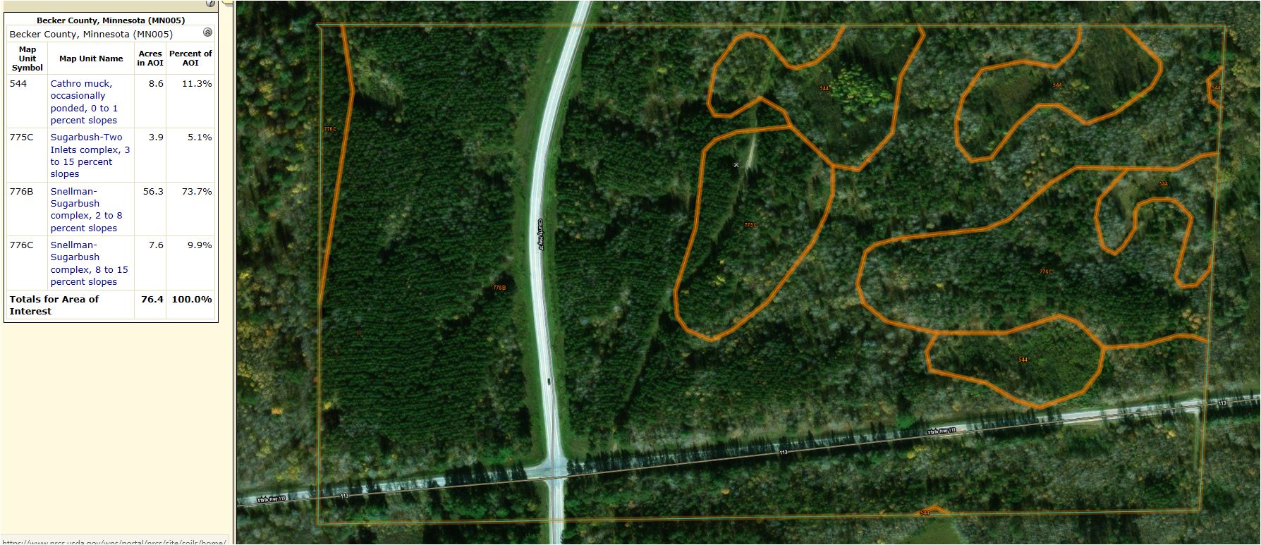
Estimated Upland %
89%
89%
Estimated Wetland %
11%
11%
Additional Comments
Timber Comments
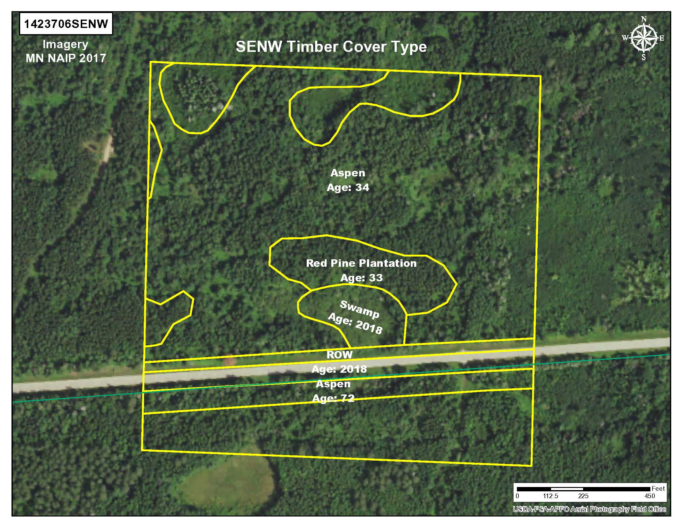
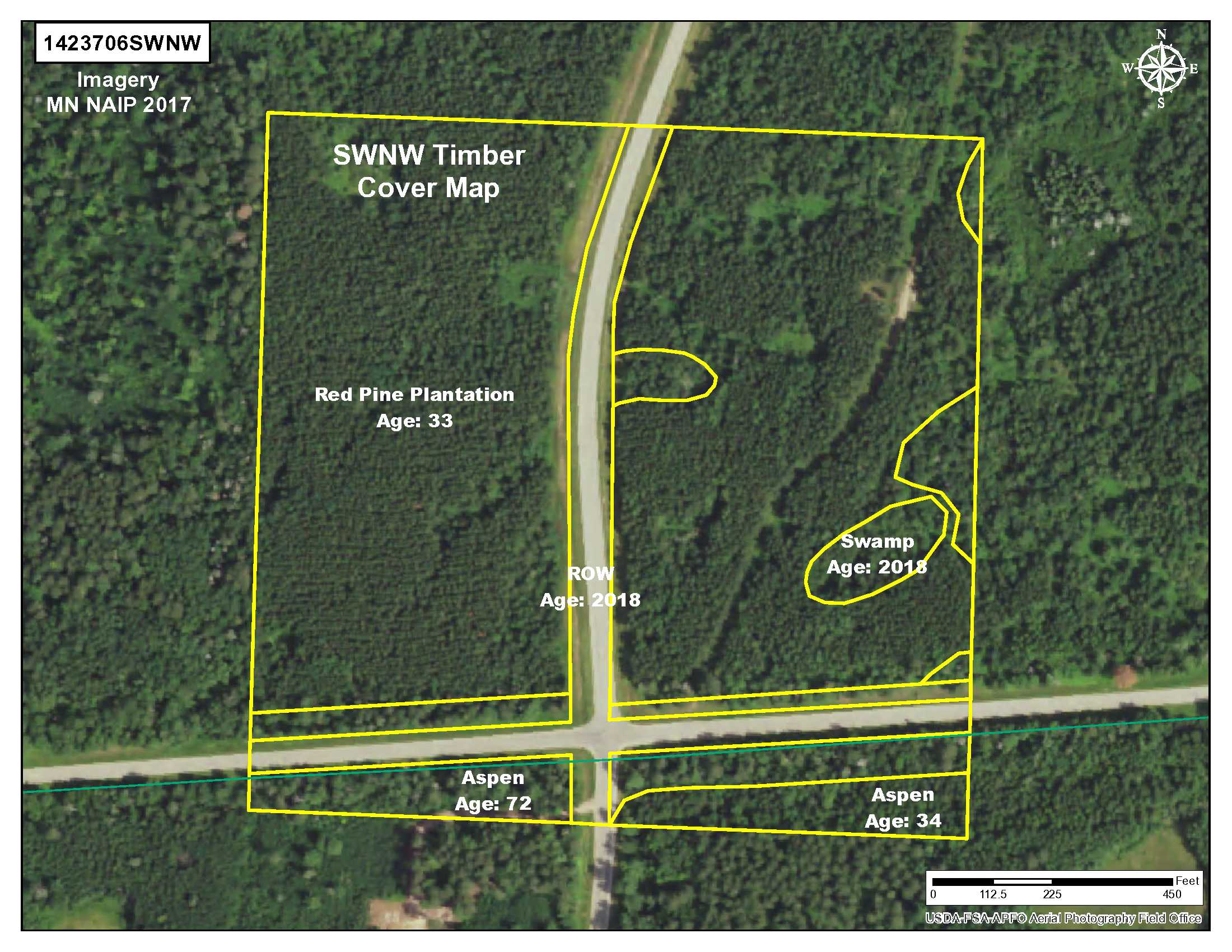
This property has been managed according to Forest Stewardship Council (FSC) standards. If timber value is important to you, seek the advice of a competent forester to determine species, volumes, and values. West of Co Rd 37 is 33 year-old red pine plantation. The balance of the property is mostly 34 year-old aspen.
This property has been managed according to Forest Stewardship Council (FSC) standards. If timber value is important to you, seek the advice of a competent forester to determine species, volumes, and values. West of Co Rd 37 is 33 year-old red pine plantation. The balance of the property is mostly 34 year-old aspen.
Hunting Comments
Hunting zone: GL 5 and SENW – permit area 184 (North of Co Rd 113) and area 298 south of Co Rd 113
Hunting zone: GL 5 and SENW – permit area 184 (North of Co Rd 113) and area 298 south of Co Rd 113
Disclosures
This parcel represents a split of PID #120041010; taxes were estimated to be ½ of the total taxes for the entire parcel. Zoned Agricultural. Acreage, dimensions, and taxes are estimated based on county data and mapping or Seller data and is not guaranteed. County disclaimers included by reference; subject to split approval if necessary.The property has not been surveyed and if accurate corner location is important to your use, it is recommended you hire a registered land surveyor. Photos/maps for convenience only and not guaranteed; physically inspect prior to purchase. Any deer stands on the land are not property of seller and are not included in sale. Use seller-approved PA and addendum; closing dates the 3rd Wednesday each month.
This parcel represents a split of PID #120041010; taxes were estimated to be ½ of the total taxes for the entire parcel. Zoned Agricultural. Acreage, dimensions, and taxes are estimated based on county data and mapping or Seller data and is not guaranteed. County disclaimers included by reference; subject to split approval if necessary.The property has not been surveyed and if accurate corner location is important to your use, it is recommended you hire a registered land surveyor. Photos/maps for convenience only and not guaranteed; physically inspect prior to purchase. Any deer stands on the land are not property of seller and are not included in sale. Use seller-approved PA and addendum; closing dates the 3rd Wednesday each month.


