MLS Number : 4654635
Sold $53,450 - Home & Cabin Sites
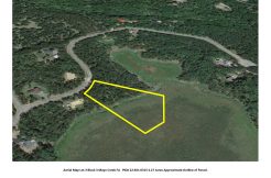
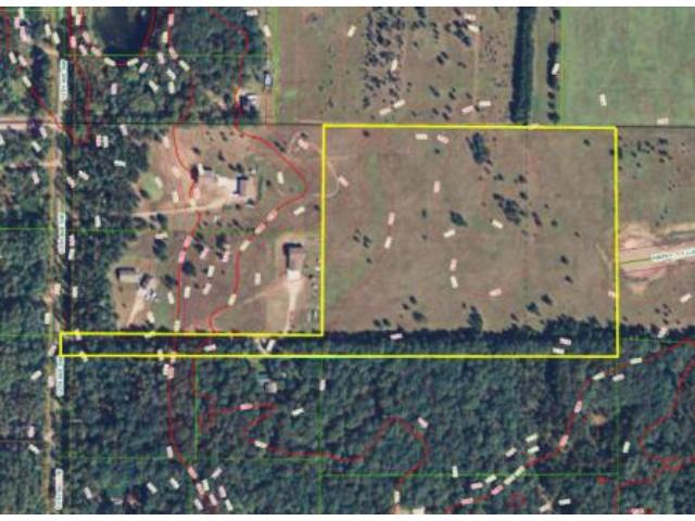
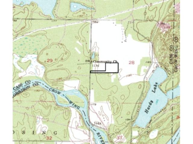
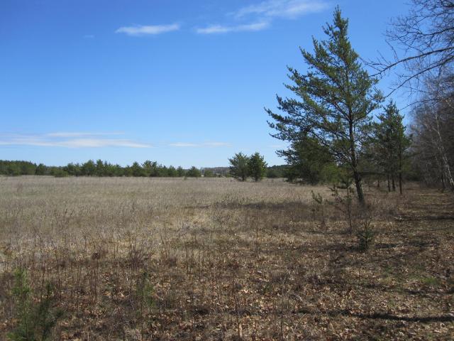
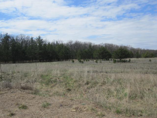
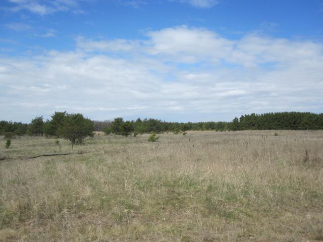
Estate-sized home site in a prime location west of Baxter/Brainerd. 14+ acres of open, level land that has been surveyed and offers over 12 acres of buildable area set back from the road for privacy. It has rural feeling but is located on a paved twp road in an established neighborhood w/ shopping, medical facilities, schools, dining, and entertainment minutes away. An excellent spot close to Hardy Lake and the Crow Wing River so you can enjoy the Brainerd Lakes vacation area year-round!
Main Property Info
Property ID
411283400
411283400
MLS Number
4654635
4654635
Status
Sold
Sold
List Price
$56,900
$56,900
Selling Price
$53,450
$53,450
Acres
14.600
14.600
Zoning
Rural Residential 2.5
Rural Residential 2.5
City
Pillager
Pillager
Township
Sylvan Twp
Sylvan Twp
State
MN
MN
Zip Code
56473
56473
County
Cass
Cass
Legal Description
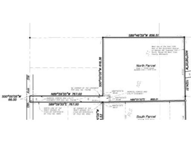
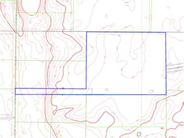
"North Parcel" - Pt of Tract B, RLS #31, 28-133-29. Subject to ingress/egress/utility easement; easement in Doc. No. T19748; deed restrictions; and any other easements, restrictions, or reservations of record. (See survey for full legal description.)
"North Parcel" - Pt of Tract B, RLS #31, 28-133-29. Subject to ingress/egress/utility easement; easement in Doc. No. T19748; deed restrictions; and any other easements, restrictions, or reservations of record. (See survey for full legal description.)
Property Location
Directions
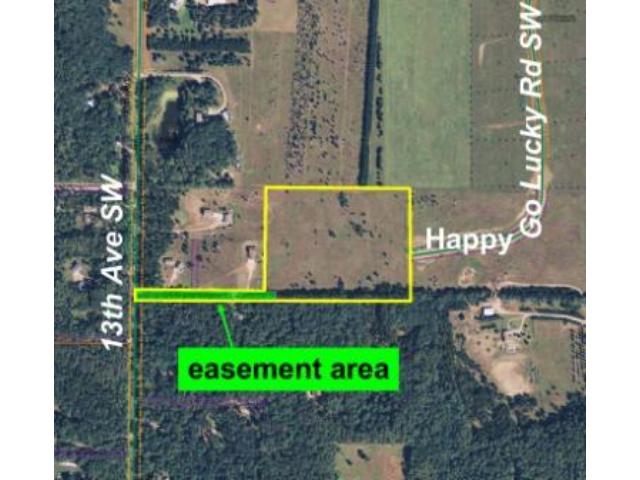
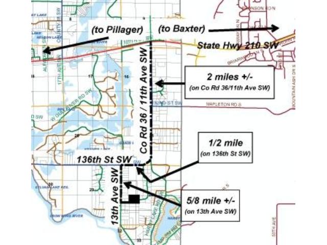
From State Hwy 210 & State Hwy 371 in Baxter, west on State Hwy 210 for 4 6/10 miles. Left on CR 36/11th Ave SW/Camp Jim Rd/Hardy Lake Rd 2 miles. Veer right on 136th St SW 1/2 mile. Left on 13th Ave SW 5/8 mile to easement trail on left (at address #13824, 13828, 13830) which goes over the property
From State Hwy 210 & State Hwy 371 in Baxter, west on State Hwy 210 for 4 6/10 miles. Left on CR 36/11th Ave SW/Camp Jim Rd/Hardy Lake Rd 2 miles. Veer right on 136th St SW 1/2 mile. Left on 13th Ave SW 5/8 mile to easement trail on left (at address #13824, 13828, 13830) which goes over the property
Access
A 66-foot-wide easement portion of the tract fronts 13th Ave SW, and the easement trail leads into the southwest corner of the property. ALTERNATE DIRECTIONS VIA HAPPY GO LUCKY RD SW: From State Hwy 210 & State Hwy 371 in Baxter, west on State Hwy 210 for 4 6/10 miles. Left(south) on Co Rd 36/11th Ave SW/Camp Jim Rd/Hardy Lake Rd 2 miles. Veer right(west) on 136th St SW 1/10 mile. Left(south) on Happy Go Lucky Rd SW 8/10 mile to property straight ahead at end of cul-de-sac.
A 66-foot-wide easement portion of the tract fronts 13th Ave SW, and the easement trail leads into the southwest corner of the property. ALTERNATE DIRECTIONS VIA HAPPY GO LUCKY RD SW: From State Hwy 210 & State Hwy 371 in Baxter, west on State Hwy 210 for 4 6/10 miles. Left(south) on Co Rd 36/11th Ave SW/Camp Jim Rd/Hardy Lake Rd 2 miles. Veer right(west) on 136th St SW 1/10 mile. Left(south) on Happy Go Lucky Rd SW 8/10 mile to property straight ahead at end of cul-de-sac.
GPS Coordinates
GPS coordinates to approx corners and points based on county mapping: Point where the easement trail starts at 13th Ave SW = 46.3023, -94.3487;
GPS coordinates to approx corners and points based on county mapping: Point where the easement trail starts at 13th Ave SW = 46.3023, -94.3487;
Address
TBD 13th Avenue
TBD 13th Avenue
School District
Pillager - 116
Pillager - 116
Property Details
Dimensions (approx)
684x673x856x868
684x673x856x868
Utilities
Available Utilities
Electric
Electric
On Site Utilities
Electric
Electric
Power Company
Crow Wing Power (1-800-648-9401)
Crow Wing Power (1-800-648-9401)
Taxes & Fees
Association Fee
$0
$0
Tax Amount
$468
$468
Assessment Amount
0
0
Tax With Assessments
$468
$468
Tax Year
2016
2016
Other Details
Section Number
28
28
Township Number
133
133
Range Number
29
29
Estimated Upland %
99
99
Estimated Wetland %
1
1
Additional Comments
Timber Comments
This property has been managed according to Forest Stewardship Council (FSC) standards. If timber value is important to you, seek the advice of a competent forester to determine species, volumes and values.
This property has been managed according to Forest Stewardship Council (FSC) standards. If timber value is important to you, seek the advice of a competent forester to determine species, volumes and values.
Disclosures
Subject to ingress, egress, and utility easement; easement in Doc. No. T19748; and any other easements, restrictions, or reservations of record. See survey for exact dimensions. Acreage based on county data and mapping; county disclaimers included by reference. Photos/maps for convenience only and not guaranteed; tree cover may be different than depicted; physically inspect prior to purchase.
Subject to ingress, egress, and utility easement; easement in Doc. No. T19748; and any other easements, restrictions, or reservations of record. See survey for exact dimensions. Acreage based on county data and mapping; county disclaimers included by reference. Photos/maps for convenience only and not guaranteed; tree cover may be different than depicted; physically inspect prior to purchase.