

MLS Number : 4826925
Sold $61,000 - Hunting & Recreation
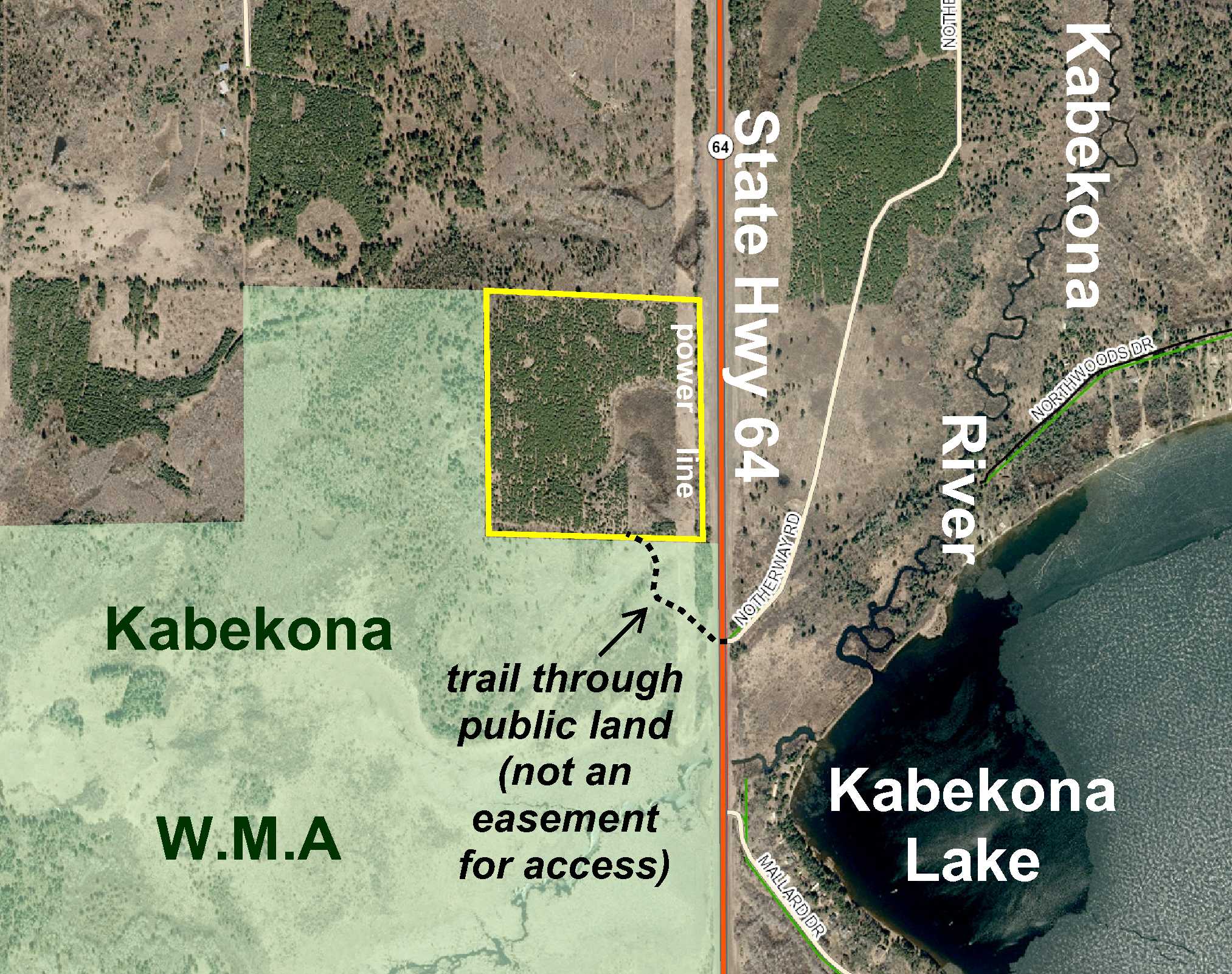
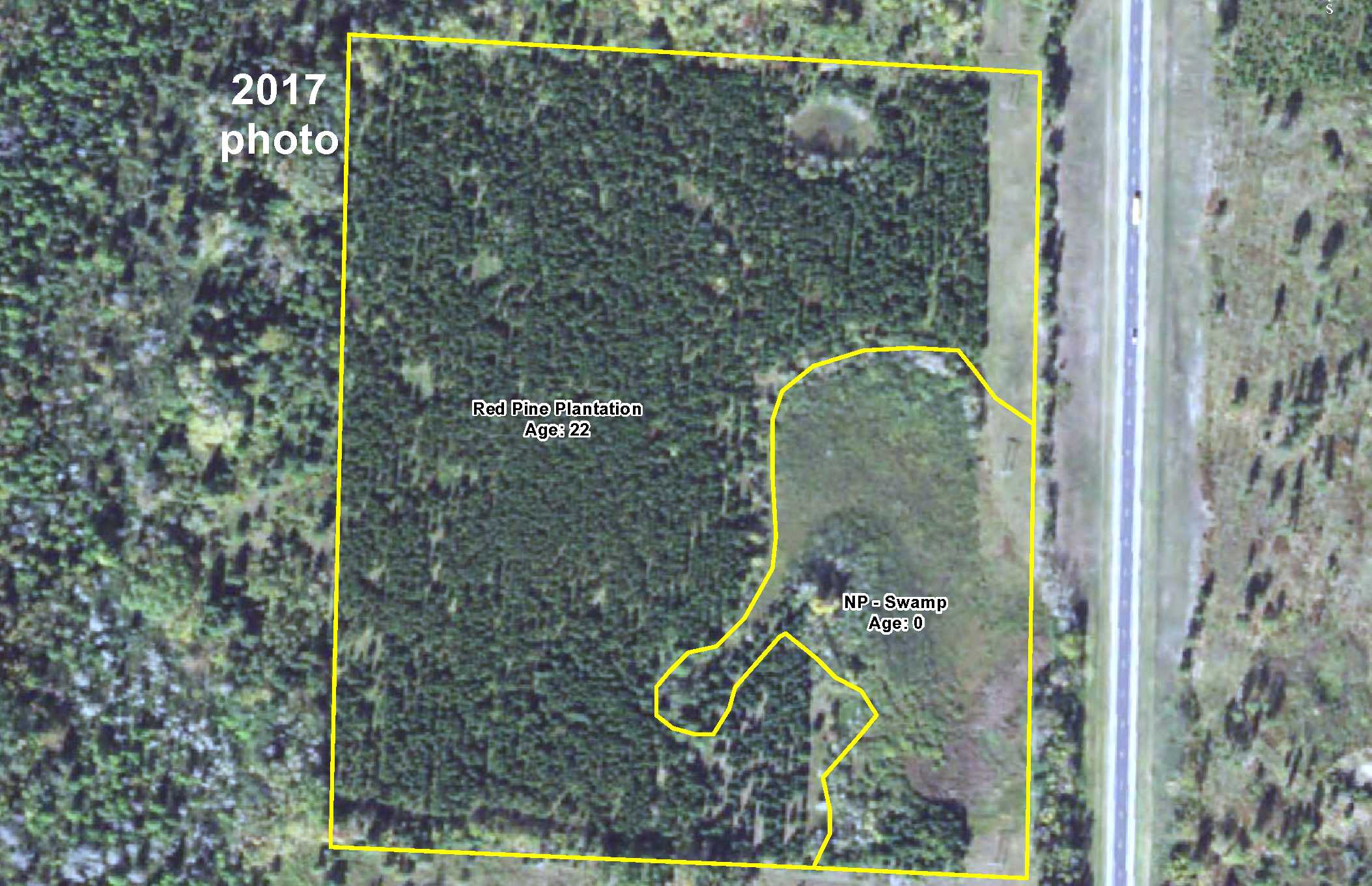
Great tract of Potlatch land by Kabekona Lake southwest of Laporte. Wooded upland slopes toward wetland in the southeast corner. Conveniently located on State Hwy 64 only 2 miles from Laporte with a trail through the adjoining public Kabekona WMA land (not an easement) leading into the south side of the tract. There has been focus on maintaining water levels of the wetlands in the WMA for production of waterfowl as well as regeneration of lowland brush and management of young and old age forest to provide a variety of habitat types, so this property is sure to be abundant with wildlife for all of your hunting ventures!
Main Property Info
Property ID
122400600
122400600
MLS Number
4826925
4826925
Status
Sold
Sold
List Price
$69,900
$69,900
Selling Price
$61,000
$61,000
Acres
36.15
36.15
Zoning
not zoned
not zoned
City
Laporte
Laporte
Township
Hendrickson Twp
Hendrickson Twp
State
MN
MN
Zip Code
56461
56461
County
Hubbard
Hubbard
Legal Description
NWSE except highway right-of-way, 24-143-33. Subject to power line and easements, restrictions, or reservations of record.
NWSE except highway right-of-way, 24-143-33. Subject to power line and easements, restrictions, or reservations of record.
Property Location
Directions
From the intersection of State Hwy 200 and State Hwy 64 west of Laporte, south on State Hwy 64 for 2 miles to northeast corner of the property (approx 2/10 mile past address #36701). [To view property: Continue another 3/10 mile, turn right on trail (not an easement), and follow trail northwesterly and north through public WMA land into south side of property.]
From the intersection of State Hwy 200 and State Hwy 64 west of Laporte, south on State Hwy 64 for 2 miles to northeast corner of the property (approx 2/10 mile past address #36701). [To view property: Continue another 3/10 mile, turn right on trail (not an easement), and follow trail northwesterly and north through public WMA land into south side of property.]
Access
State Hwy 64 runs along the east side of the property. A trail off State Hwy 64 leads through public land into the south part of the property; however, said trail is not an easement for access.
State Hwy 64 runs along the east side of the property. A trail off State Hwy 64 leads through public land into the south part of the property; however, said trail is not an easement for access.
GPS Coordinates
Coordinates to approximate corners/points based on flagging and county mapping: NE corner along State Hwy 64 = 47.1870, -94.7965; SE corner along State Hwy 64 = 47.1834, -94.7964; point where trail through public land enters south side of property = 47.1834, -94.7989; SW corner (near where trail exits west side of the property) = 47.1835, -94.8017; NW corner = 47.1871, -94.8017.
Coordinates to approximate corners/points based on flagging and county mapping: NE corner along State Hwy 64 = 47.1870, -94.7965; SE corner along State Hwy 64 = 47.1834, -94.7964; point where trail through public land enters south side of property = 47.1834, -94.7989; SW corner (near where trail exits west side of the property) = 47.1835, -94.8017; NW corner = 47.1871, -94.8017.
Address
State Hwy 64
State Hwy 64
School District
Laporte - 306
Laporte - 306
Property Details
Dimensions (approx)
1320 x 1180 x 1320 x 1180
1320 x 1180 x 1320 x 1180
Utilities
Power Company
Beltrami Electric (1-800-955-6083)
Beltrami Electric (1-800-955-6083)
Taxes & Fees
Tax Amount
$374
$374
Assessment Amount
0
0
Tax With Assessments
$374
$374
Tax Year
2017
2017
Other Details
Section Number
24
24
Township Number
143
143
Range Number
33
33
Estimated Upland %
75
75
Estimated Wetland %
25
25
Additional Comments
Timber Comments
This property has been managed according to Forest Stewardship Council (FSC) standards and is wooded in red pine plantation. If timber value is important to you, seek the advice of a competent forester to determine species, volumes and values.
This property has been managed according to Forest Stewardship Council (FSC) standards and is wooded in red pine plantation. If timber value is important to you, seek the advice of a competent forester to determine species, volumes and values.
Hunting Comments
This property adjoins public land in MN Firearms Deer Zone 259. The adjoining Kabekona WMA has been the focus of wetland management to maintain water levels for the production of waterfowl and regeneration of lowland brush and young and old age forest management to provide a variety of habitat types for wildlife. Game species include deer, bear, small game, forest upland birds, and waterfowl.
This property adjoins public land in MN Firearms Deer Zone 259. The adjoining Kabekona WMA has been the focus of wetland management to maintain water levels for the production of waterfowl and regeneration of lowland brush and young and old age forest management to provide a variety of habitat types for wildlife. Game species include deer, bear, small game, forest upland birds, and waterfowl.
Disclosures
Not surveyed; acreage and dimensions approximate based on county data and mapping; county disclaimers included by reference. Photos/maps for convenience only and not guaranteed; physically inspect prior to purchase. Any deer stands on the land are not property of seller and are not included in sale. Use seller-approved PA and addendum; closing dates the 3rd Wednesday each month.
Not surveyed; acreage and dimensions approximate based on county data and mapping; county disclaimers included by reference. Photos/maps for convenience only and not guaranteed; physically inspect prior to purchase. Any deer stands on the land are not property of seller and are not included in sale. Use seller-approved PA and addendum; closing dates the 3rd Wednesday each month.


