
MLS Number : 4730027
Sold $44,353 - Hunting & Recreation
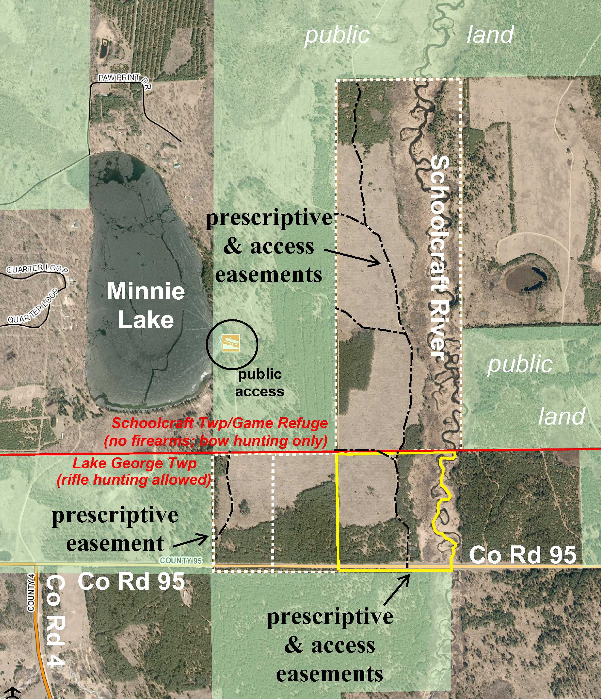
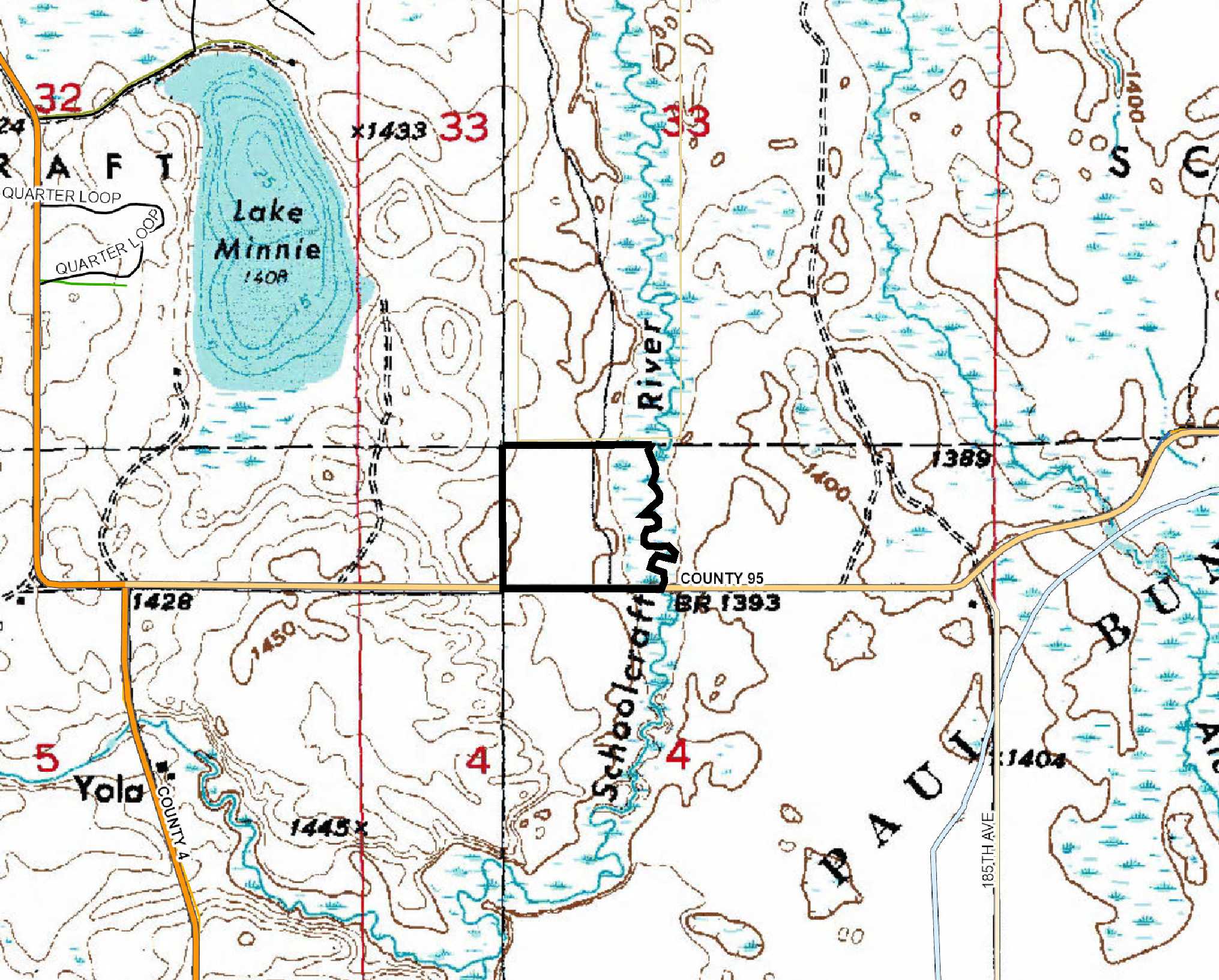
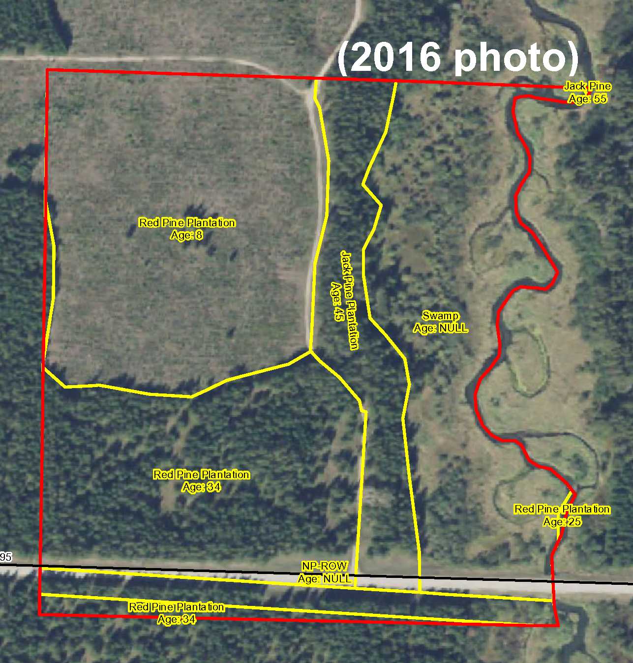
Potlatch land on the Schoolcraft River just off the shores of Lake Minnie northeast of Lake George. Tract has been surveyed. Level to sloping topography with the river as the east boundary. Timber includes red pine and jack pine. Gravel county road along the south and an easement trail provides access through the entire tract. Public Paul Bunyan State Forest land adjoins the south. Minutes from Itasca State Park.
Main Property Info
Property ID
170400500
170400500
MLS Number
4730027
4730027
Status
Sold
Sold
List Price
$49,900
$49,900
Selling Price
$44,353
$44,353
Acres
32.69
32.69
Zoning
east half is in Forested River Shoreland Zone
east half is in Forested River Shoreland Zone
City
Lake George
Lake George
Township
Lake George Twp
Lake George Twp
State
MN
MN
Zip Code
56458
56458
County
Hubbard
Hubbard
Legal Description
Pt GL3 lying west of river, 4-143-34. Subject to Co Rd 95; prescriptive easement, easement to be granted, and easement to be retained over existing trail; and any other easements, restrictions, or reservations of record.
Pt GL3 lying west of river, 4-143-34. Subject to Co Rd 95; prescriptive easement, easement to be granted, and easement to be retained over existing trail; and any other easements, restrictions, or reservations of record.
Property Location
Directions
From the intersection of US Hwy 71/State Hwy 200 & CR 4 in Lake George, east on US Hwy 71/State Hwy 200 for 1/2 mile. Left on CR 68 (185th Ave) for 2 miles. Left on CR 95 for 6/10 mile to easement trail on right which leads northerly through the entire tract. (ALTERNATE DIRECTIONS: From the intersection of US Hwy 71/State Hwy 200 and Co Rd 4 in Lake George, north then west then north on Co Rd 4 for 3 2/10 miles. Right on Co Rd 95 for 8/10 mile to to easement trail on left which leads northerly through the entire tract.)
From the intersection of US Hwy 71/State Hwy 200 & CR 4 in Lake George, east on US Hwy 71/State Hwy 200 for 1/2 mile. Left on CR 68 (185th Ave) for 2 miles. Left on CR 95 for 6/10 mile to easement trail on right which leads northerly through the entire tract. (ALTERNATE DIRECTIONS: From the intersection of US Hwy 71/State Hwy 200 and Co Rd 4 in Lake George, north then west then north on Co Rd 4 for 3 2/10 miles. Right on Co Rd 95 for 8/10 mile to to easement trail on left which leads northerly through the entire tract.)
Access
Gravel Co Rd 95 is along the south and an easement trail provides access through the entire tract.
Gravel Co Rd 95 is along the south and an easement trail provides access through the entire tract.
GPS Coordinates
Coordinates to approximate corners/points based on county mapping: Point where easement trail off Co Rd 95 enters property = 47.2363, -94.9967; SE corner along Co Rd 95 = 47.2361, -94.9948; SW corner along Co Rd 95 = 47.2361, -94.9997; NW corner = 47.2396, -94.9997; point where easement trail exits north boundary = 47.2396, -94.9971; NE corner (river) = 47.2396, -94.9946.
Coordinates to approximate corners/points based on county mapping: Point where easement trail off Co Rd 95 enters property = 47.2363, -94.9967; SE corner along Co Rd 95 = 47.2361, -94.9948; SW corner along Co Rd 95 = 47.2361, -94.9997; NW corner = 47.2396, -94.9997; point where easement trail exits north boundary = 47.2396, -94.9971; NE corner (river) = 47.2396, -94.9946.
Address
County Road 95
County Road 95
School District
Laporte - 306
Laporte - 306
Property Details
Dimensions (approx)
1221 x 1311 x 1228 x 1880
1221 x 1311 x 1228 x 1880
Utilities
Power Company
Itasca-Mantrap Co-op (1-888-713-3377)
Itasca-Mantrap Co-op (1-888-713-3377)
Waterfront
Waterfront Name
Schoolcraft River
Schoolcraft River
Waterfront Feet (approx)
1880
1880
Taxes & Fees
Tax Amount
$466
$466
Tax With Assessments
$466
$466
Assessment Pending
No
No
Tax Year
2016
2016
Other Details
Section Number
4
4
Township Number
143
143
Range Number
34
34
Estimated Upland %
65
65
Estimated Wetland %
35
35
Additional Comments
Timber Comments
This property has been managed according to Forest Stewardship Council (FSC) standards. Timber includes red pine and jack pine. If timber value is important to you, seek the advice of a competent forester to determine species, volumes and values.
This property has been managed according to Forest Stewardship Council (FSC) standards. Timber includes red pine and jack pine. If timber value is important to you, seek the advice of a competent forester to determine species, volumes and values.
Hunting Comments
This property adjoins public land in MN Firearms Deer Zone 184.
This property adjoins public land in MN Firearms Deer Zone 184.
Disclosures
FEMA has not determined flood hazard conditions for this area; however, the river may be prone to flooding. See survey for exact dimensions; survey indicates approx 35 acres whereas county parcel info indicates 32.69 acres. County disclaimers included by reference. Photos/maps for convenience only and not guaranteed; tree cover may be different than depicted; physically inspect prior to purchase. Any deer stands on the land are not property of seller and are not included in sale. Use seller-approved PA and addendum; closing dates the 2nd Wednesday each month.
FEMA has not determined flood hazard conditions for this area; however, the river may be prone to flooding. See survey for exact dimensions; survey indicates approx 35 acres whereas county parcel info indicates 32.69 acres. County disclaimers included by reference. Photos/maps for convenience only and not guaranteed; tree cover may be different than depicted; physically inspect prior to purchase. Any deer stands on the land are not property of seller and are not included in sale. Use seller-approved PA and addendum; closing dates the 2nd Wednesday each month.


