
MLS Number : 4716988
Sold $41,900 - Hunting & Recreation
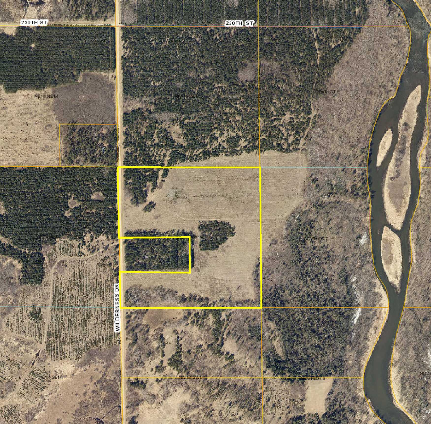
Potlatch land by the Crow Wing River south of Nimrod. Fairly-level terrain with small wetland area along south boundary. Gravel county road access along the west. Public land with trail to the river adjoins the north and east sides.
Main Property Info
Property ID
R060352010
R060352010
MLS Number
4716988
4716988
Status
Sold
Sold
List Price
$41,900
$41,900
Selling Price
$41,900
$41,900
Acres
35
35
Zoning
A-2 Mixed Agriculture
A-2 Mixed Agriculture
City
Wadena
Wadena
Township
Lyons Township
Lyons Township
State
MN
MN
Zip Code
56481
56481
County
Wadena
Wadena
Legal Description
SWNW exc north 5 acres of south 10 acres of west 20 acres, 35-136-33. Subject to any easements, restrictions, or reservations of record.
SWNW exc north 5 acres of south 10 acres of west 20 acres, 35-136-33. Subject to any easements, restrictions, or reservations of record.
Property Location
Directions
From intersection of Co Rd 12 & Co Rd 26 at the south end of Nimrod, south on Co Rd 26 for 4 1/10 miles. Left on Co Rd 9 for 3 miles. Right on Wilderness Dr (Co Rd 138) for 1 1/4 mile to NW corner of the property.
From intersection of Co Rd 12 & Co Rd 26 at the south end of Nimrod, south on Co Rd 26 for 4 1/10 miles. Left on Co Rd 9 for 3 miles. Right on Wilderness Dr (Co Rd 138) for 1 1/4 mile to NW corner of the property.
Access
Gravel county road (Wilderness Dr) is along the west side.
Gravel county road (Wilderness Dr) is along the west side.
GPS Coordinates
See Supplements for a map of flagged points.
See Supplements for a map of flagged points.
Address
Wilderness Drive
Wilderness Drive
School District
Sebeka - 820
Sebeka - 820
Property Details
Dimensions (approx)
1320x1320x1320x1320
1320x1320x1320x1320
Utilities
Power Company
Todd-Wadena Electric (1-800-320-8932)
Todd-Wadena Electric (1-800-320-8932)
Taxes & Fees
Tax Amount
$476
$476
Tax With Assessments
$476
$476
Tax Year
2016
2016
Other Details
Section Number
35
35
Township Number
136
136
Range Number
33
33
Estimated Upland %
95
95
Estimated Wetland %
5
5
Additional Comments
Timber Comments
This property has been managed according to Forest Stewardship Council (FSC) standards. If timber value is important to you, seek the advice of a competent forester to determine species, volumes and values.
This property has been managed according to Forest Stewardship Council (FSC) standards. If timber value is important to you, seek the advice of a competent forester to determine species, volumes and values.
Disclosures
Parcel was recently split; parcel report reflects 2016 taxes for previous 75-acre tract; taxes shown here are estimated for the subject 35-acre tract. Not surveyed; acreage and dimensions approx based on county data and mapping; county disclaimers included by reference. Photos/maps for convenience only and not guaranteed; tree cover may be different than depicted; physically inspect prior to purchase. Any deer stands on the land are not property of seller and are not included in sale. Use seller-approved PA and addendum; closing dates the 2nd Wednesday each month.
Parcel was recently split; parcel report reflects 2016 taxes for previous 75-acre tract; taxes shown here are estimated for the subject 35-acre tract. Not surveyed; acreage and dimensions approx based on county data and mapping; county disclaimers included by reference. Photos/maps for convenience only and not guaranteed; tree cover may be different than depicted; physically inspect prior to purchase. Any deer stands on the land are not property of seller and are not included in sale. Use seller-approved PA and addendum; closing dates the 2nd Wednesday each month.


