

MLS Number : 5325074
Sold $60,000 - Hunting & Recreation
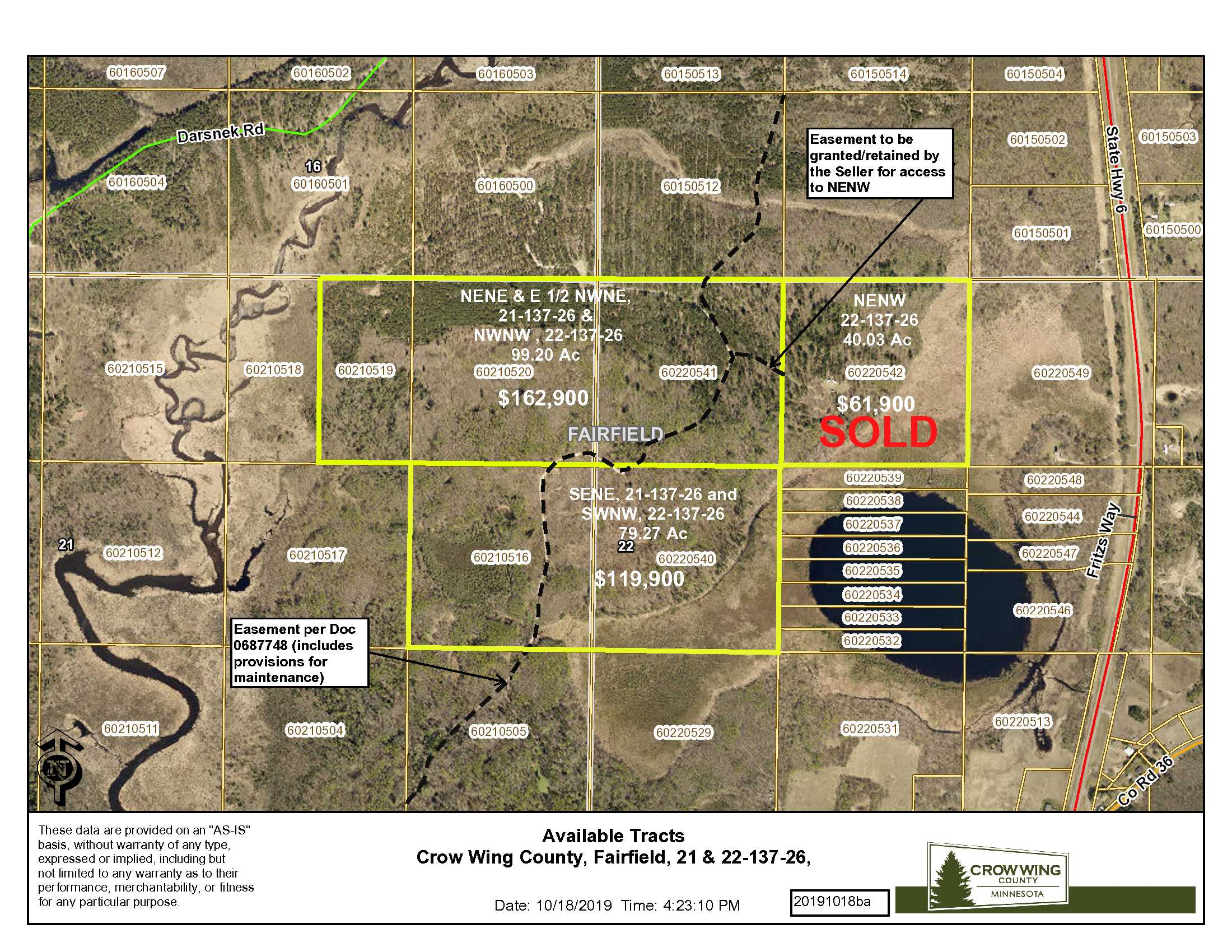
This 40 acre tract is minutes away from Crosslake, Emily and Crosby. Gently rolling terrain and a mix of red pine, jack pine, and aspen make this an excellent hunting/recreational land investment. Big Al’s Bar and Grill and Olson’s Mercantile are just minutes away at the intersection of Co Rd 36 and Hwy 6 and Crosslake is just over 7 miles to the west. Additional land is available.
Main Property Info
Property ID
60220542 (Legacy 600222100000009)
60220542 (Legacy 600222100000009)
MLS Number
5325074
5325074
Status
Sold
Sold
List Price
$61,900
$61,900
Selling Price
$60,000
$60,000
Acres
40
40
Zoning
RR 2.5 & Shoreline per map
RR 2.5 & Shoreline per map
City
Crosby
Crosby
Township
Fairfield Twp
Fairfield Twp
State
MN
MN
Zip Code
56441
56441
County
Crow Wing
Crow Wing
Legal Description
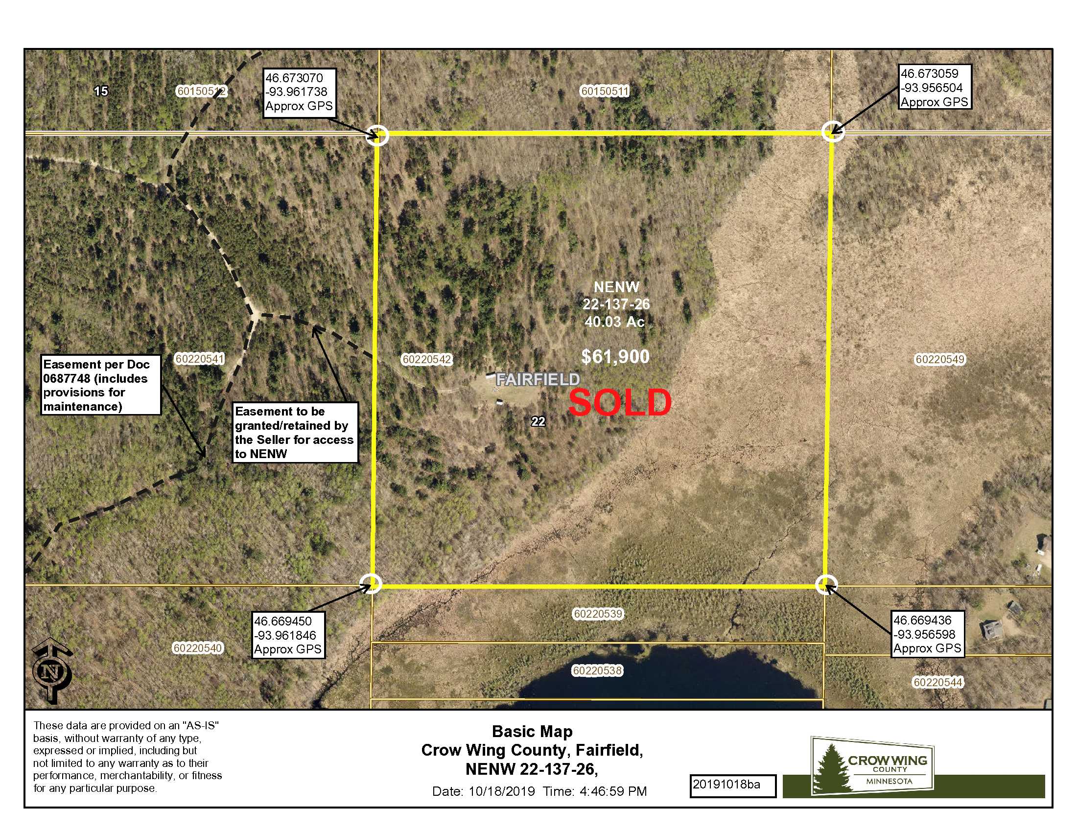
NENW, 22-137-26, with easements for ingress, egress and utility purposes.
NENW, 22-137-26, with easements for ingress, egress and utility purposes.
Property Location
Directions
From the intersection of Hwy 6 and Co Rd 36 (12.9 miles north of Crosby MN); West on Co Rd 36 1.2 miles to easement road on the North side of Co Rd 36; Northerly and Easterly on the easement road 1 mile to the westerly boundary of the tract. Approximate GPS coordinate to this location is: Lat 46.671272, Lon -93.961791
From the intersection of Hwy 6 and Co Rd 36 (12.9 miles north of Crosby MN); West on Co Rd 36 1.2 miles to easement road on the North side of Co Rd 36; Northerly and Easterly on the easement road 1 mile to the westerly boundary of the tract. Approximate GPS coordinate to this location is: Lat 46.671272, Lon -93.961791
Access
Access is via private easements over private property, as described in Document #0687748, from Co Rd 36 (about 1.2 miles west of State Hwy 6). See mapping for the course of the easement road. Approximate GPS coordinate to this location is: Lat 46.671272, Lon -93.961791
Access is via private easements over private property, as described in Document #0687748, from Co Rd 36 (about 1.2 miles west of State Hwy 6). See mapping for the course of the easement road. Approximate GPS coordinate to this location is: Lat 46.671272, Lon -93.961791
GPS Coordinates
Coordinates to approximate corners/points based on county mapping: NW: 46.673070, -93.961738 NE: 46.673059, -93.956504 SE: 46.669436, -93.956598 SW: 46.669450, -93.961846
Coordinates to approximate corners/points based on county mapping: NW: 46.673070, -93.961738 NE: 46.673059, -93.956504 SE: 46.669436, -93.956598 SW: 46.669450, -93.961846
Address
TBD Pt 22-137-26, Off Co Rd 36, Fairfield Twp, Emily, MN 56441
TBD Pt 22-137-26, Off Co Rd 36, Fairfield Twp, Emily, MN 56441
School District
Crosby-Ironton - 182
Crosby-Ironton - 182
Property Details
Pasture Acres
0
0
Wooded Acres
26
26
Dimensions (approx)
1320’ x 1320’ x 1320’ x 1320’
1320’ x 1320’ x 1320’ x 1320’
Utilities
Available Utilities
None
None
On Site Utilities
None
None
Power Company
Crow Wing Power (1-800-648-9401)
Crow Wing Power (1-800-648-9401)
Waterfront
Waterfront Name
N/A
N/A
Waterfront Number
N/A
N/A
Waterfront Feet (approx)
N/A
N/A
Waterfront Comments
N/A
N/A
Taxes & Fees
Has Association Fee
No
No
Association Fee
$0
$0
Association Fee Includes
N/A
N/A
Tax Amount
$292
$292
Assessment Amount
0
0
Tax With Assessments
$292
$292
Assessment Pending
No
No
Assessment Description
N/a
N/a
Tax Year
2019
2019
Other Details
Section Number
22
22
Township Number
137
137
Range Number
26
26
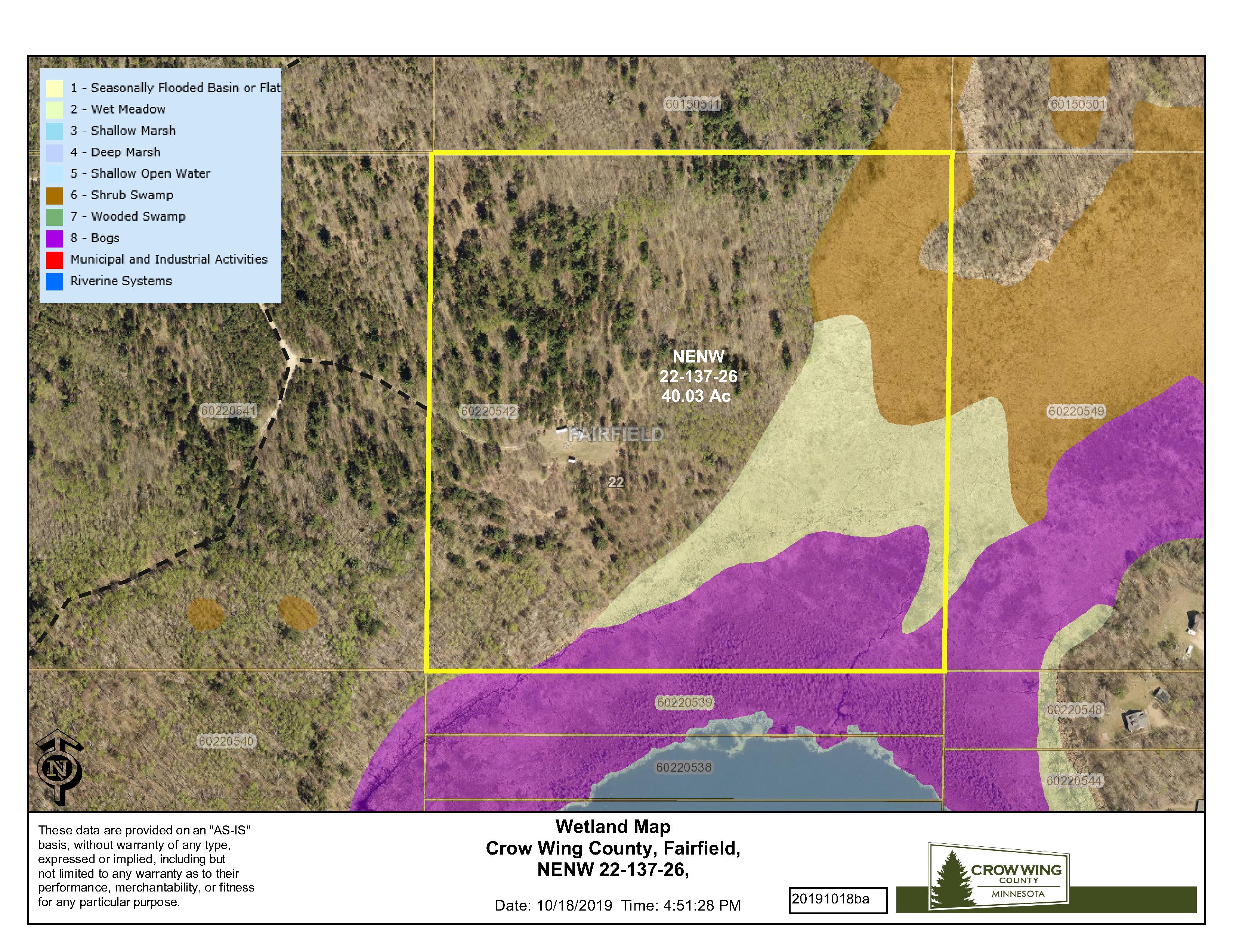
Estimated Upland %
65
65
Estimated Wetland %
35
35
Additional Comments
Timber Comments
Combination of Red Pine 23-73 years. Aspen 20-27 years. Jack Pine 70 years.
Combination of Red Pine 23-73 years. Aspen 20-27 years. Jack Pine 70 years.
Hunting Comments
Deer Permit Area: 604
Deer Permit Area: 604
Disclosures
Easement(s) affect this property. See legal description and maps for details. Shared easements affect this property and easements granted and reserved/retained will include terms governing shared use of the easements. Acreage, dimensions, and taxes estimated based on county data and mapping or seller data; county disclaimers included by reference; subject to split approval if necessary. Not surveyed. Photos/maps and GPS coordinates for convenience only and not guaranteed; physically inspect prior to purchase. Any deer stands on the land are not property of seller and are not included in sale
Easement(s) affect this property. See legal description and maps for details. Shared easements affect this property and easements granted and reserved/retained will include terms governing shared use of the easements. Acreage, dimensions, and taxes estimated based on county data and mapping or seller data; county disclaimers included by reference; subject to split approval if necessary. Not surveyed. Photos/maps and GPS coordinates for convenience only and not guaranteed; physically inspect prior to purchase. Any deer stands on the land are not property of seller and are not included in sale


