


MLS Number : 4957181
Sold $199,900 - Hunting & Recreation
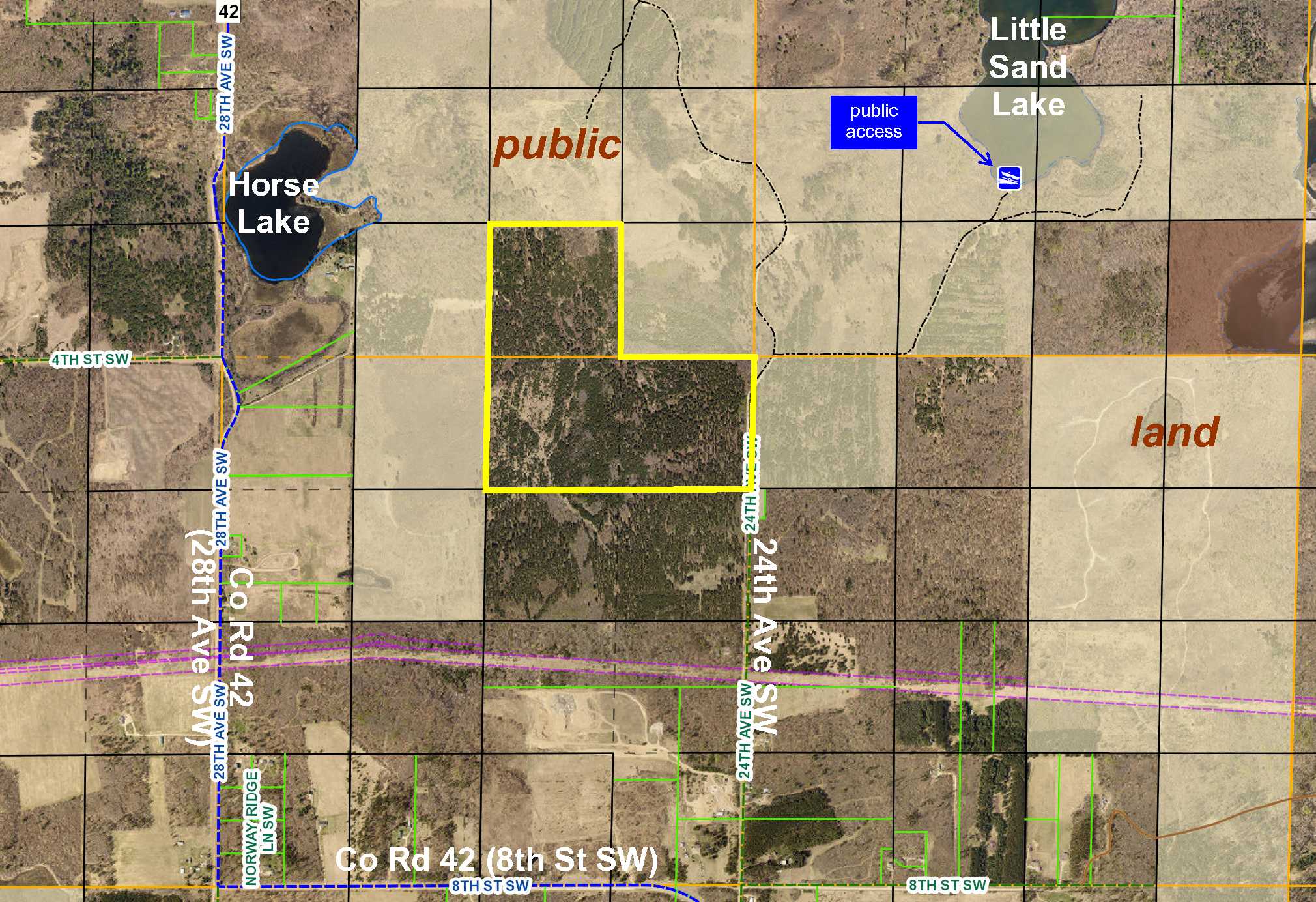
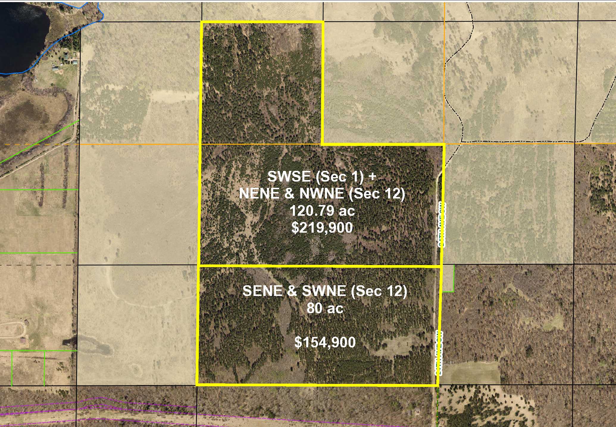
Rural PotlatchDeltic land by Little Sand Lake and Horse Lake north of Pine River. Upland with rolling topography and wooded with red pine, jack pine, and aspen. Gravel township road along the east side. Public land adjoins the north, west, and east sides for plenty of hunting, ATV riding, and snowmobiling space. Public access to Little Sand Lake only 1 mile away. Utilities are within 1/4 mile.
Main Property Info
Property ID
310014300 & Pt 310121100
310014300 & Pt 310121100
MLS Number
4957181
4957181
Status
Sold
Sold
List Price
$219,900
$219,900
Selling Price
$199,900
$199,900
Acres
120.79
120.79
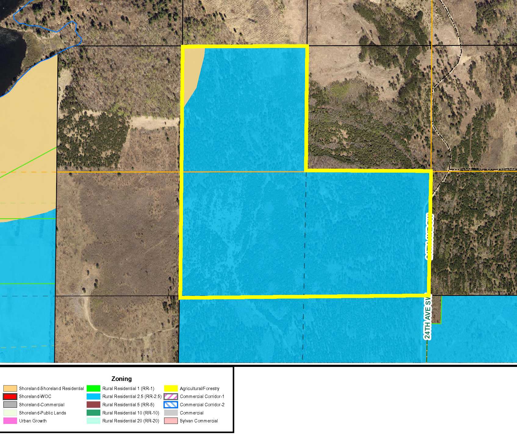
Zoning
Rural Res 2.5
Rural Res 2.5
City
Backus
Backus
Township
Pine River Twp
Pine River Twp
State
MN
MN
Zip Code
56435
56435
County
Cass
Cass
Legal Description
SWSE, 1-138-30 and NENE & NWNE, 12-138-30. Subject to 24th Ave SW and any easements, restrictions, or reservations of record.
SWSE, 1-138-30 and NENE & NWNE, 12-138-30. Subject to 24th Ave SW and any easements, restrictions, or reservations of record.
Property Location
Directions
From the intersection of State Hwy 371 and Co Rd 42 in Pine River, northeast on Co Rd 42 for 4 miles. Veer right onto 24th Ave SW 3/4 mile to property on left.
From the intersection of State Hwy 371 and Co Rd 42 in Pine River, northeast on Co Rd 42 for 4 miles. Veer right onto 24th Ave SW 3/4 mile to property on left.
Access
Gravel township road 24th Ave SW is along the east side.
Gravel township road 24th Ave SW is along the east side.
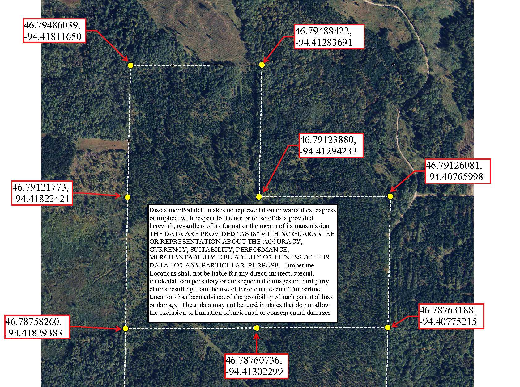
GPS Coordinates
See map for coordinates to flagged approximate corners/points.
See map for coordinates to flagged approximate corners/points.
Address
24th Ave SW
24th Ave SW
School District
Pine River-Backus - 2174
Pine River-Backus - 2174
Property Details
Dimensions (approx)
1320 x 2640 x 2640 x 1320 x 1320 x 1320 IRR
1320 x 2640 x 2640 x 1320 x 1320 x 1320 IRR
Utilities
Power Company
Crow Wing Power (1-800-648-9401)
Crow Wing Power (1-800-648-9401)
Taxes & Fees
Tax Amount
$1,471
$1,471
Tax Year
2018
2018
Other Details
Section Number
01 & 12
01 & 12
Township Number
138
138
Range Number
30
30
Estimated Upland %
99
99
Estimated Wetland %
1
1
Additional Comments
Timber Comments
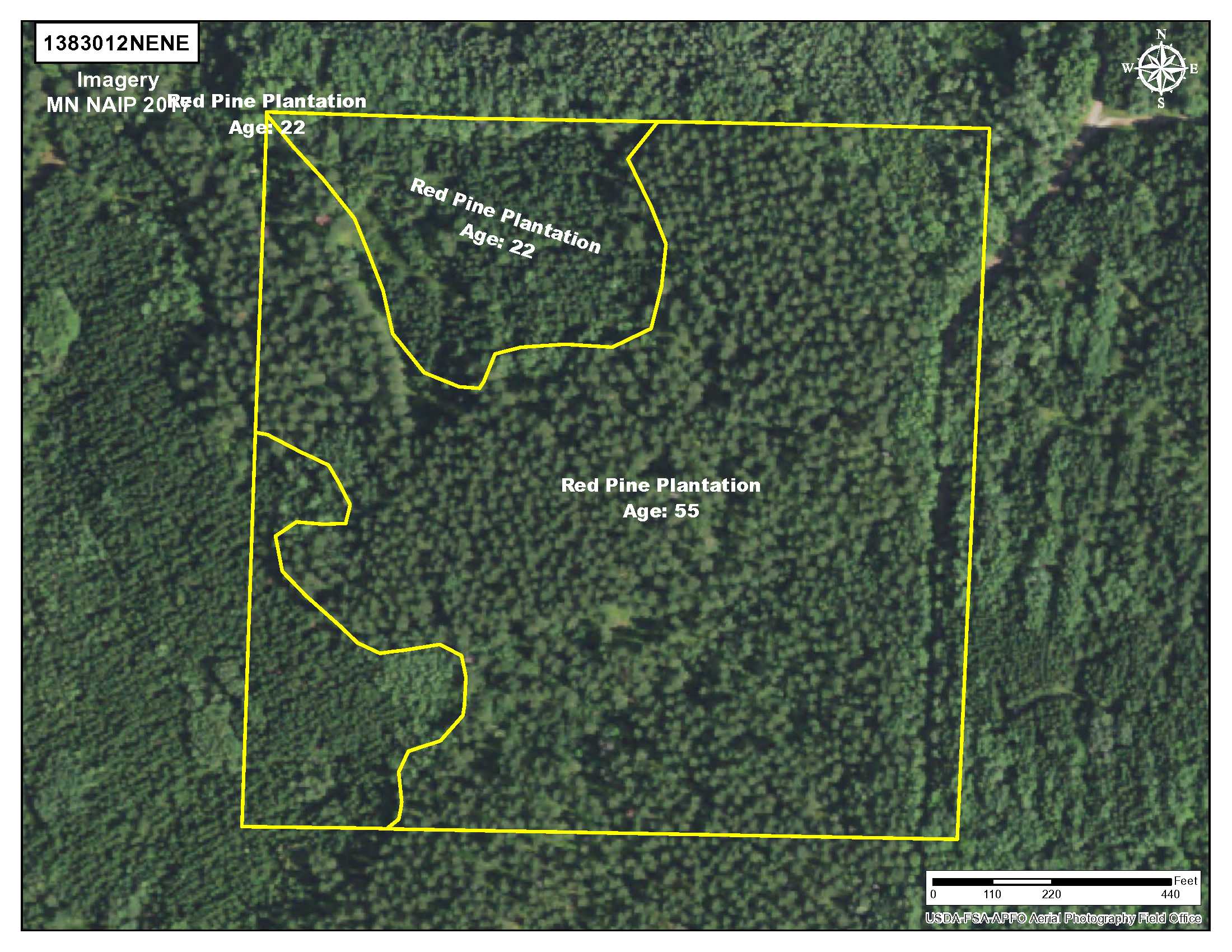
This property has been managed according to Forest Stewardship Council (FSC) standards and is wooded with red pine, jack pine, and aspen. If timber value is important to you, seek the advice of a competent forester to determine species, volumes, and values.
This property has been managed according to Forest Stewardship Council (FSC) standards and is wooded with red pine, jack pine, and aspen. If timber value is important to you, seek the advice of a competent forester to determine species, volumes, and values.
Hunting Comments
This property adjoins public land in MN Firearms Deer Zone 172.
This property adjoins public land in MN Firearms Deer Zone 172.
Disclosures
Parcel split (PID 310121100); acreage, dimensions, and taxes estimated based on county data and mapping; county disclaimers included by reference; subject to split approval if necessary. Not surveyed. Photos/maps for convenience only and not guaranteed; physically inspect prior to purchase. Any deer stands on the land are not property of seller and are not included in sale. Use seller-approved PA and addendum; closing dates the 3rd Wednesday each month.
Parcel split (PID 310121100); acreage, dimensions, and taxes estimated based on county data and mapping; county disclaimers included by reference; subject to split approval if necessary. Not surveyed. Photos/maps for convenience only and not guaranteed; physically inspect prior to purchase. Any deer stands on the land are not property of seller and are not included in sale. Use seller-approved PA and addendum; closing dates the 3rd Wednesday each month.


