


MLS Number : 4652294
Sold $82,000 - Hunting & Recreation
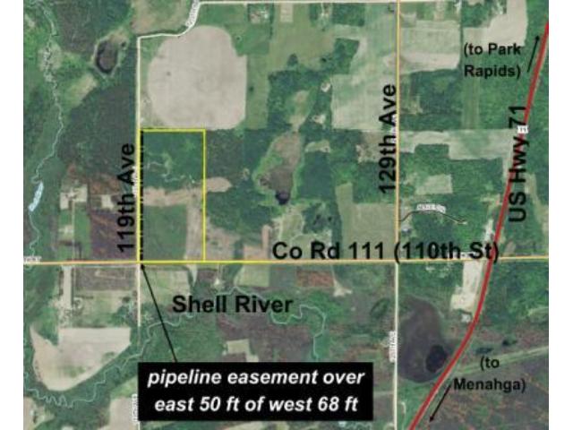
Priced below county’s ELV! Great opportunity to own a large tract of Potlatch land conveniently located just over a mile off US Hwy 71 between Menahga and Park Rapids. Terrain is mostly level to gently-rolling upland. May have agricultural potential. Good gravel roads along the south and west. Shell River is only 1/4 mile south. Pipeline easement runs near the west line. Timber was damaged by fire in 2013 but is regenerating.
Main Property Info
Property ID
252800500
252800500
MLS Number
4652294
4652294
Status
Sold
Sold
List Price
$89,900
$89,900
Selling Price
$82,000
$82,000
Acres
80.000
80.000
Zoning
not zoned
not zoned
City
Menahga
Menahga
Township
Straight River Township
Straight River Township
State
MN
MN
Zip Code
56464
56464
County
Hubbard
Hubbard
Legal Description
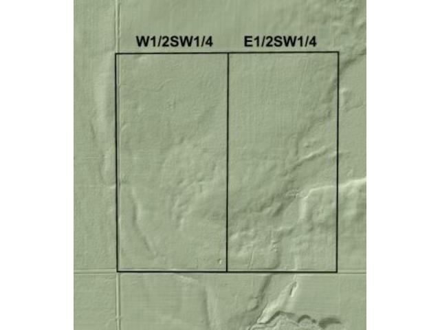
W1/2SW1/4, 28-139-35. Subject to Co Rd 111 (110th St); 119th Ave; pipeline easement over the east 50 ft of the west 68 ft per Doc #209214; and any other easements, restrictions, or reservations of record.
W1/2SW1/4, 28-139-35. Subject to Co Rd 111 (110th St); 119th Ave; pipeline easement over the east 50 ft of the west 68 ft per Doc #209214; and any other easements, restrictions, or reservations of record.
Property Location
Directions
From intersection of US Hwy 71 and Co Rd 111 (110th St) between Menahga and Park Rapids, west on Co Rd 111 (110th St) 1 2/10 miles to property on right (across from address #12117). (SW corner is at intersection of Co Rd 111 (110th St) and 119th Ave.)
From intersection of US Hwy 71 and Co Rd 111 (110th St) between Menahga and Park Rapids, west on Co Rd 111 (110th St) 1 2/10 miles to property on right (across from address #12117). (SW corner is at intersection of Co Rd 111 (110th St) and 119th Ave.)
Access
Unpaved Co Rd 111 (110th St) is along the south boundary of this land and unpaved 119th Ave is along the west boundary.
Unpaved Co Rd 111 (110th St) is along the south boundary of this land and unpaved 119th Ave is along the west boundary.
GPS Coordinates
GPS coordinates to approximate corners and points based on county mapping: SE corner along Co Rd 111 (110th St) = 46.8196, -95.1160; SW corner at the intersection of Co Rd 111 (110th St) and 119th Ave = 46.8196, -95.1214; NW corner along 119th Ave = 46.8269, -95.1213; NE corner = 46.8269, -95.1159
GPS coordinates to approximate corners and points based on county mapping: SE corner along Co Rd 111 (110th St) = 46.8196, -95.1160; SW corner at the intersection of Co Rd 111 (110th St) and 119th Ave = 46.8196, -95.1214; NW corner along 119th Ave = 46.8269, -95.1213; NE corner = 46.8269, -95.1159
Address
W2SW 110th Street
W2SW 110th Street
School District
Park Rapids - 309
Park Rapids - 309
Property Details
Dimensions (approx)
1320x1320x2640x2640
1320x1320x2640x2640
Utilities
Available Utilities
Electric
Electric
On Site Utilities
None
None
Power Company
Itasca-Mantrap Co-op (1-888-713-3377)
Itasca-Mantrap Co-op (1-888-713-3377)
Taxes & Fees
Association Fee
$0
$0
Tax Amount
$698
$698
Tax With Assessments
$698
$698
Tax Year
2015
2015
Other Details
Section Number
28
28
Township Number
139
139
Range Number
35
35
Additional Comments
Timber Comments
This property has been managed according to Forest Stewardship Council (FSC) standards. Timber was damaged by fire in 2013 but is regenerating. If timber value is important to you, seek the advice of a competent forester to determine species, volumes and values.
This property has been managed according to Forest Stewardship Council (FSC) standards. Timber was damaged by fire in 2013 but is regenerating. If timber value is important to you, seek the advice of a competent forester to determine species, volumes and values.
Hunting Comments
This property is near public land.
This property is near public land.
Disclosures
Subject to pipeline easement over the east 50 ft of the west 68 ft per Doc #209214. Not surveyed; acreage and dimensions approximate based on county data and mapping; county disclaimers included by reference. Photos/maps for convenience only and not guaranteed; tree cover may be different than depicted; physically inspect prior to purchase. Any deer stands on the land are not property of seller and are not included in sale. Use seller-approved PA and addendum; closing dates the 2nd Wednesday each month.
Subject to pipeline easement over the east 50 ft of the west 68 ft per Doc #209214. Not surveyed; acreage and dimensions approximate based on county data and mapping; county disclaimers included by reference. Photos/maps for convenience only and not guaranteed; tree cover may be different than depicted; physically inspect prior to purchase. Any deer stands on the land are not property of seller and are not included in sale. Use seller-approved PA and addendum; closing dates the 2nd Wednesday each month.


