
MLS Number : 4968614
Sold $740,000 - Hunting & Recreation, Premier & Development
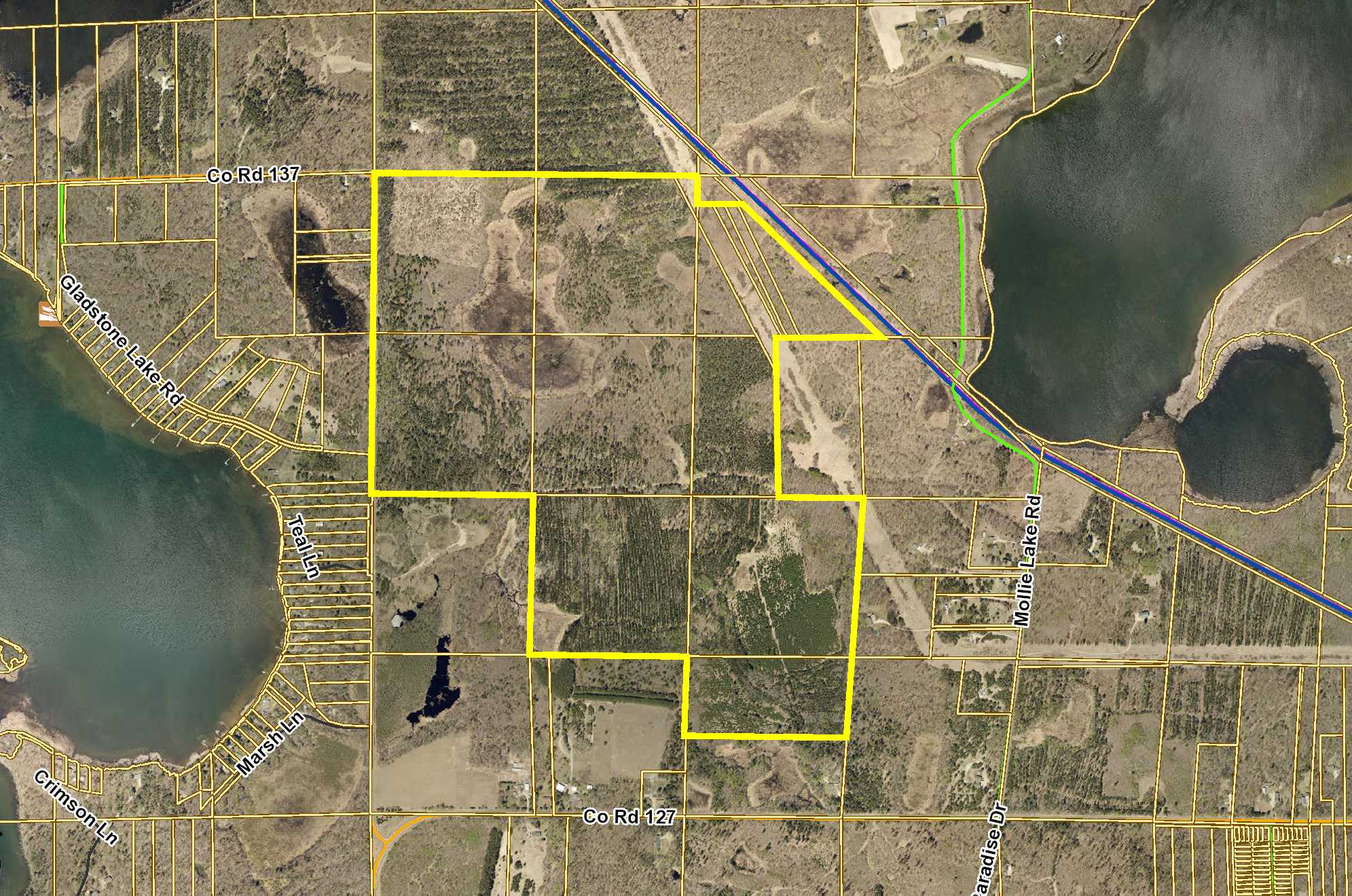
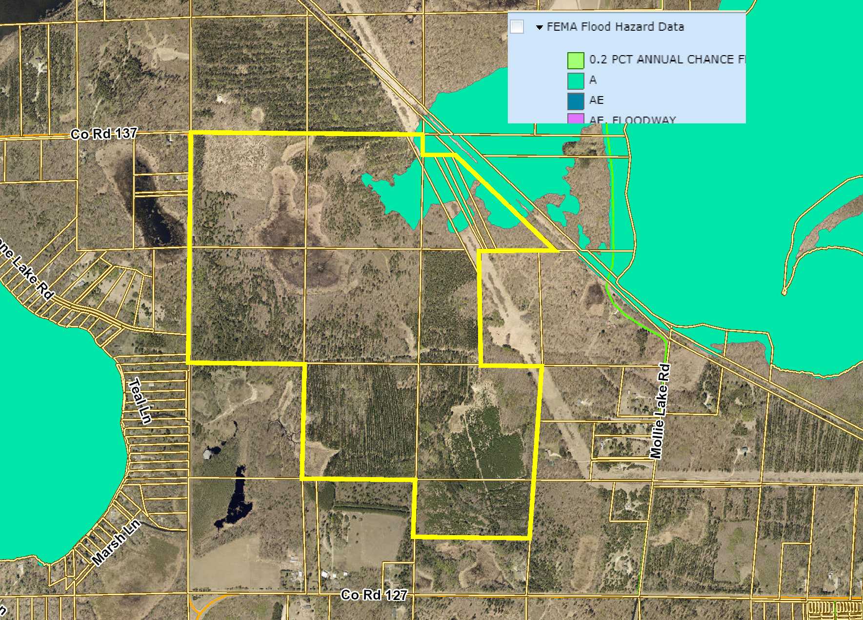
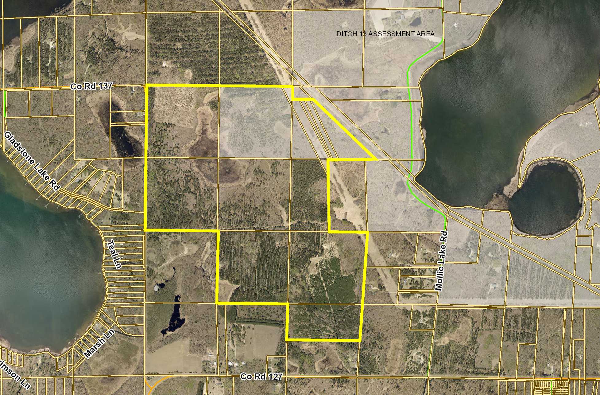
Expansive PotlatchDeltic land between Mollie Lake and Gladstone Lake southeast of Nisswa. Approx 300 acres of varying terrain combining upland and wetland. Timber is primarily aspen and red pine along with some oak and jack pine. Paved county road along the west side for access. Paul Bunyan Trail for walking, biking, snowmobiling and other recreation is along portion of the northeast side. Public access to Gladstone Lake less than a mile away. Zoned to allow for future subdivision or development.
Main Property Info
Property ID
Pt 730281201B00009 & 730281201C00009 & 730281300B00009 & 730282100000009 & 730282100A00009 & 730282200000009 & 730282300000009 & 730282400000009 & 730283100000009 & 730284200000009 & 730284300A00009
Pt 730281201B00009 & 730281201C00009 & 730281300B00009 & 730282100000009 & 730282100A00009 & 730282200000009 & 730282300000009 & 730282400000009 & 730283100000009 & 730284200000009 & 730284300A00009
MLS Number
4968614
4968614
Status
Sold
Sold
List Price
$810,200
$810,200
Selling Price
$740,000
$740,000
Acres
300
300
Zoning
Rural Res 2.5 & Rural Res 10 & Rural Res 20 & Shoreland
Rural Res 2.5 & Rural Res 10 & Rural Res 20 & Shoreland
City
Nisswa
Nisswa
Township
Lake Edward Twp
Lake Edward Twp
State
MN
MN
Zip Code
56468
56468
County
Crow Wing
Crow Wing
Legal Description
Pt GL1 lying west of Paul Bunyan Trail & N1/2SWSE & NESW & NW1/4 & NWSE & W1/2SWNE, 28-135-28. Subject to Co Rd 137 and any easements, restrictions, or reservations of record.
Pt GL1 lying west of Paul Bunyan Trail & N1/2SWSE & NESW & NW1/4 & NWSE & W1/2SWNE, 28-135-28. Subject to Co Rd 137 and any easements, restrictions, or reservations of record.
Property Location
Directions
From the intersection of State Hwy 371 and Ojibwa Rd north of Brainerd/Baxter, east on Ojibwa Rd 2.3 miles. Right on Co Rd 127 N (Ojibwa Park Rd N) 2.6 miles. Left on Co Rd 137 N for 0.6 mile to property on right (across from Gladstone Ln).
From the intersection of State Hwy 371 and Ojibwa Rd north of Brainerd/Baxter, east on Ojibwa Rd 2.3 miles. Right on Co Rd 127 N (Ojibwa Park Rd N) 2.6 miles. Left on Co Rd 137 N for 0.6 mile to property on right (across from Gladstone Ln).
Access
Paved Co Rd 137 N is along the west side.
Paved Co Rd 137 N is along the west side.
Address
Co Rd 137
Co Rd 137
School District
Brainerd - 181
Brainerd - 181
Property Details
Dimensions (approx)
2640 x 2640 x 256 x 394 x 1627 x 907 x 1320 x 660 x 2054 x 1320 x 660 x 1320 x 1320 x 1320 IRR
2640 x 2640 x 256 x 394 x 1627 x 907 x 1320 x 660 x 2054 x 1320 x 660 x 1320 x 1320 x 1320 IRR
Utilities
Power Company
Crow Wing Power (1-800-648-9401)
Crow Wing Power (1-800-648-9401)
Taxes & Fees
Tax Amount
$3,114
$3,114
Assessment Amount
349.24
349.24
Tax With Assessments
$3,463
$3,463
Assessment Description
Ditch 13
Ditch 13
Tax Year
2018
2018
Other Details
Section Number
28
28
Township Number
135
135
Range Number
28
28
Estimated Upland %
90
90
Estimated Wetland %
10
10
Additional Comments
Timber Comments
This property has been managed according to Forest Stewardship Council (FSC) standards. If timber value is important to you, seek the advice of a competent forester to determine species, volumes, and values.
This property has been managed according to Forest Stewardship Council (FSC) standards. If timber value is important to you, seek the advice of a competent forester to determine species, volumes, and values.
Disclosures
Portions of the land fall within Ditch 13 Assessment Area and are subject to related special assessments. Portions of the land fall within FEMA Flood Zone A. Parcel split (PID 730281201B00009); acreage, dimensions, and taxes estimated based on county data and mapping; county disclaimers included by reference; subject to split approval if necessary. Not surveyed. Photos/maps for convenience only and not guaranteed; physically inspect prior to purchase. Any deer stands on the land are not property of seller and are not included in sale. Use seller-approved PA and addendum; closing dates the 3rd Wednesday each month.
Portions of the land fall within Ditch 13 Assessment Area and are subject to related special assessments. Portions of the land fall within FEMA Flood Zone A. Parcel split (PID 730281201B00009); acreage, dimensions, and taxes estimated based on county data and mapping; county disclaimers included by reference; subject to split approval if necessary. Not surveyed. Photos/maps for convenience only and not guaranteed; physically inspect prior to purchase. Any deer stands on the land are not property of seller and are not included in sale. Use seller-approved PA and addendum; closing dates the 3rd Wednesday each month.