

MLS Number : 4995977
Sold $97,000 - Hunting & Recreation
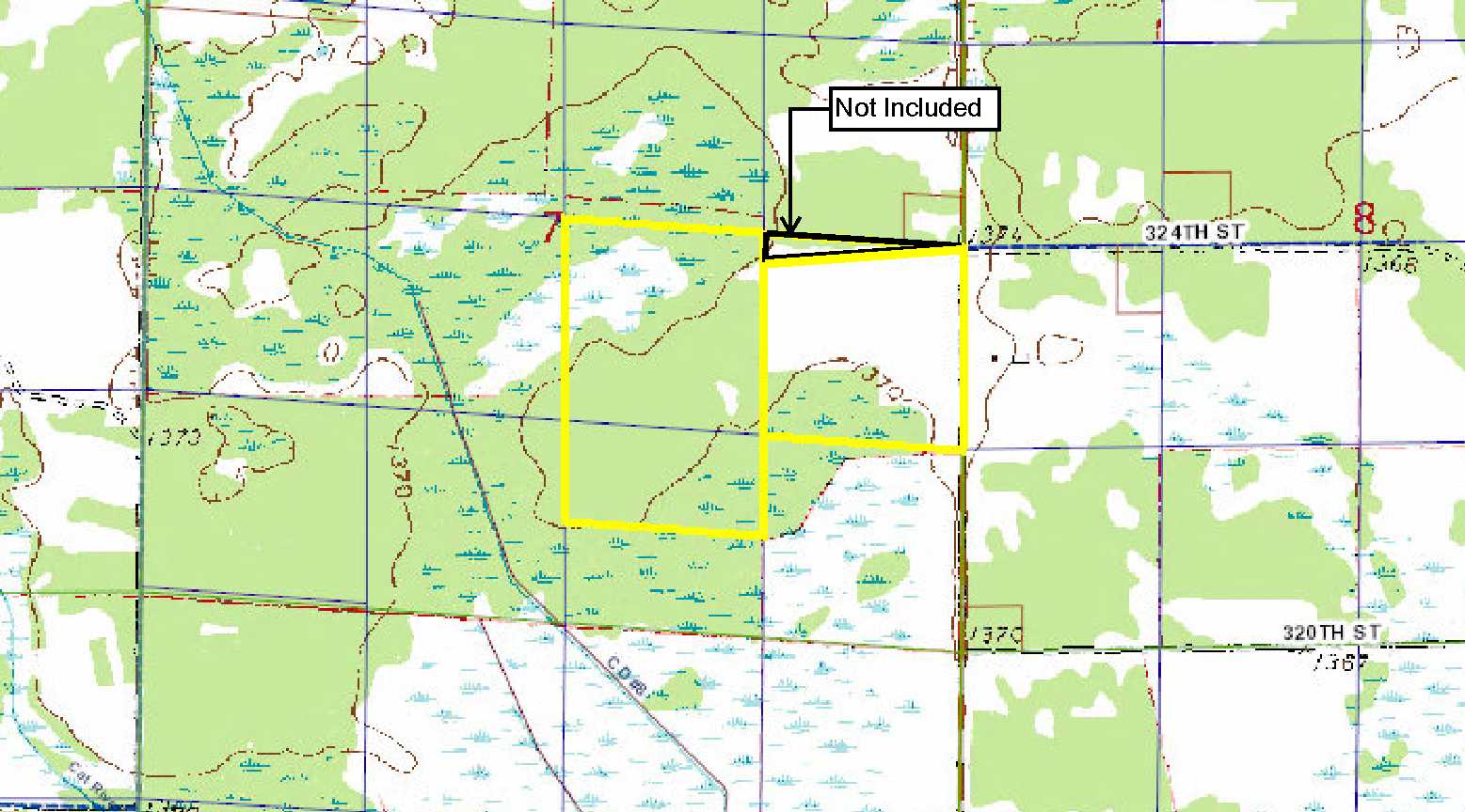
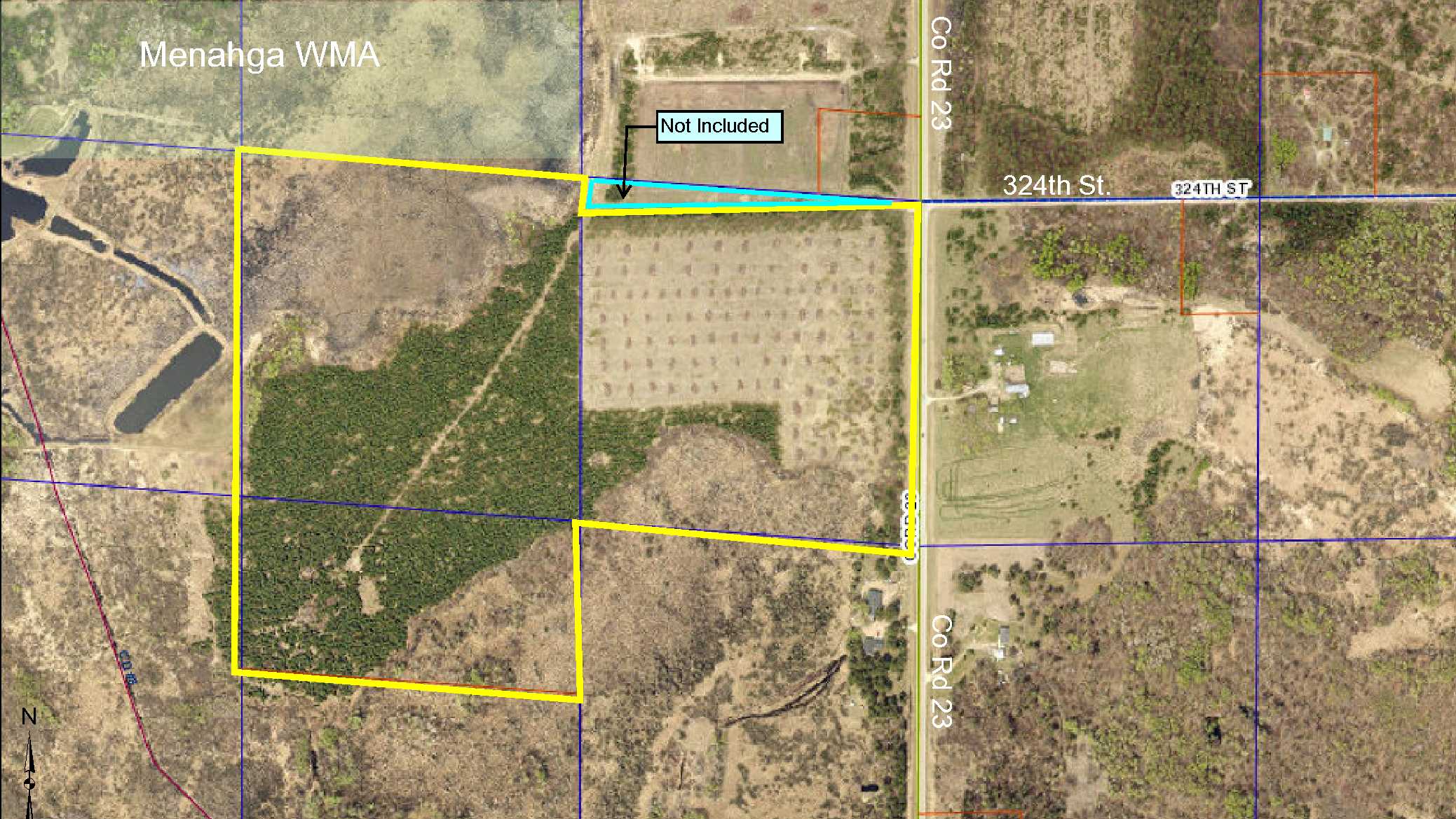
Potlatch acreage adjoining Menahga Wildlife Mgmt Area (WMA) east of Menahga and Sebeka. Level topography with wetlands in the northwest and along the south and upland throughout the middle. Paved county road access along the east side. Hunting & recreation, rural home location or potential farmland. North property line is irregular with a fenceline along the north boundary of the NESE. Timber was harvested on the NESE and buffers were left on the north and east sides with a nice red pine plantation on the balance of the property.
Main Property Info
Property ID
070074010 & 070074020
070074010 & 070074020
MLS Number
4995977
4995977
Status
Sold
Sold
List Price
$99,900
$99,900
Selling Price
$97,000
$97,000
Acres
97
97
Zoning
A-2 MIxed Agriculture
A-2 MIxed Agriculture
City
Menahga
Menahga
Township
Meadow Twp
Meadow Twp
State
MN
MN
Zip Code
56464
56464
County
Wadena
Wadena
Legal Description
pt NESE & NWSE & N2SWSE, 7-137-34. Subject to Co Rd 23 and any easements, restrictions, or reservations of record.
pt NESE & NWSE & N2SWSE, 7-137-34. Subject to Co Rd 23 and any easements, restrictions, or reservations of record.
Property Location
Directions
From the intersection of US Hwy 71 and Co Rd 13 between Sebeka and Menahga, east on Co Rd 13 for 4 4/10 miles. Right on Co Rd 23 (Hubbard Rd) for 1/2 mile to trail on right entering the northeast corner of the land.
From the intersection of US Hwy 71 and Co Rd 13 between Sebeka and Menahga, east on Co Rd 13 for 4 4/10 miles. Right on Co Rd 23 (Hubbard Rd) for 1/2 mile to trail on right entering the northeast corner of the land.
Access
Paved Co Rd 23 is along the east side of this property.
Paved Co Rd 23 is along the east side of this property.
GPS Coordinates
Coordinates to approximate corners/points based on county mapping: NE corner along Co Rd 23 (and approx trail entrance) = 46.6949, -95.0167; SE corner along Co Rd 23 = 46.6912, -95.0167; SW corner of pt NESE = 46.6915, -95.0220; NW corner of pt NESE = 46.6948, -95.0220; SE corner of N2SWSE = 46.6896, -95.0220; SW corner = 46.6899, -95.0272; NW corner = 46.6954, -95.0273.
Coordinates to approximate corners/points based on county mapping: NE corner along Co Rd 23 (and approx trail entrance) = 46.6949, -95.0167; SE corner along Co Rd 23 = 46.6912, -95.0167; SW corner of pt NESE = 46.6915, -95.0220; NW corner of pt NESE = 46.6948, -95.0220; SE corner of N2SWSE = 46.6896, -95.0220; SW corner = 46.6899, -95.0272; NW corner = 46.6954, -95.0273.
Address
NESE&NWSE&N2SWSE County Road 23
NESE&NWSE&N2SWSE County Road 23
School District
Sebeka - 820
Sebeka - 820
Property Details
Dimensions (approx)
1320 x 1320 x 660 x 1320 x 1980 x 2640
1320 x 1320 x 660 x 1320 x 1980 x 2640
Utilities
Power Company
Todd-Wadena Electric (1-800-320-8932)
Todd-Wadena Electric (1-800-320-8932)
Taxes & Fees
Tax Amount
$1,440
$1,440
Tax Year
2018
2018
Other Details
Section Number
7
7
Township Number
137
137
Range Number
34
34
Estimated Upland %
60
60
Estimated Wetland %
40
40
Additional Comments
Timber Comments
This property has been managed according to Forest Stewardship Council (FSC) standards. The upland areas of NWSE & N2 SWSE red pine plantation (Norway pine). Pt NESE has been clear cut with buffers left along the north and east sides. NOTE: Seller will be clear-cutting almost all mature pine from NESE. If timber value is important to you, seek the advice of a competent forester to determine species, volumes and values.
This property has been managed according to Forest Stewardship Council (FSC) standards. The upland areas of NWSE & N2 SWSE red pine plantation (Norway pine). Pt NESE has been clear cut with buffers left along the north and east sides. NOTE: Seller will be clear-cutting almost all mature pine from NESE. If timber value is important to you, seek the advice of a competent forester to determine species, volumes and values.
Hunting Comments
This property adjoins public land in MN Firearms Deer Zone 241. The adjoining Menahga WMA provides opportunities for hunting whitetail deer, bear, small game, forest upland birds, and waterfowl.
This property adjoins public land in MN Firearms Deer Zone 241. The adjoining Menahga WMA provides opportunities for hunting whitetail deer, bear, small game, forest upland birds, and waterfowl.
Disclosures
Boundary of NESE will run along fenceline. Buffers left on N & E after timber harvest ot NESE. Not surveyed; acreage and dimensions approximate based on county data and mapping; county disclaimers included by reference. Photos/maps for convenience only and not guaranteed; tree cover may be different than depicted; physically inspect prior to purchase. Any deer stands on the land are not property of seller and are not included in sale. Use seller-approved PA and addendum; closing dates the 3rd Wednesday each month. Seller will provide complete legal description prior to close.
Boundary of NESE will run along fenceline. Buffers left on N & E after timber harvest ot NESE. Not surveyed; acreage and dimensions approximate based on county data and mapping; county disclaimers included by reference. Photos/maps for convenience only and not guaranteed; tree cover may be different than depicted; physically inspect prior to purchase. Any deer stands on the land are not property of seller and are not included in sale. Use seller-approved PA and addendum; closing dates the 3rd Wednesday each month. Seller will provide complete legal description prior to close.


