

MLS Number : 4997784
Sold $112,900 - Hunting & Recreation
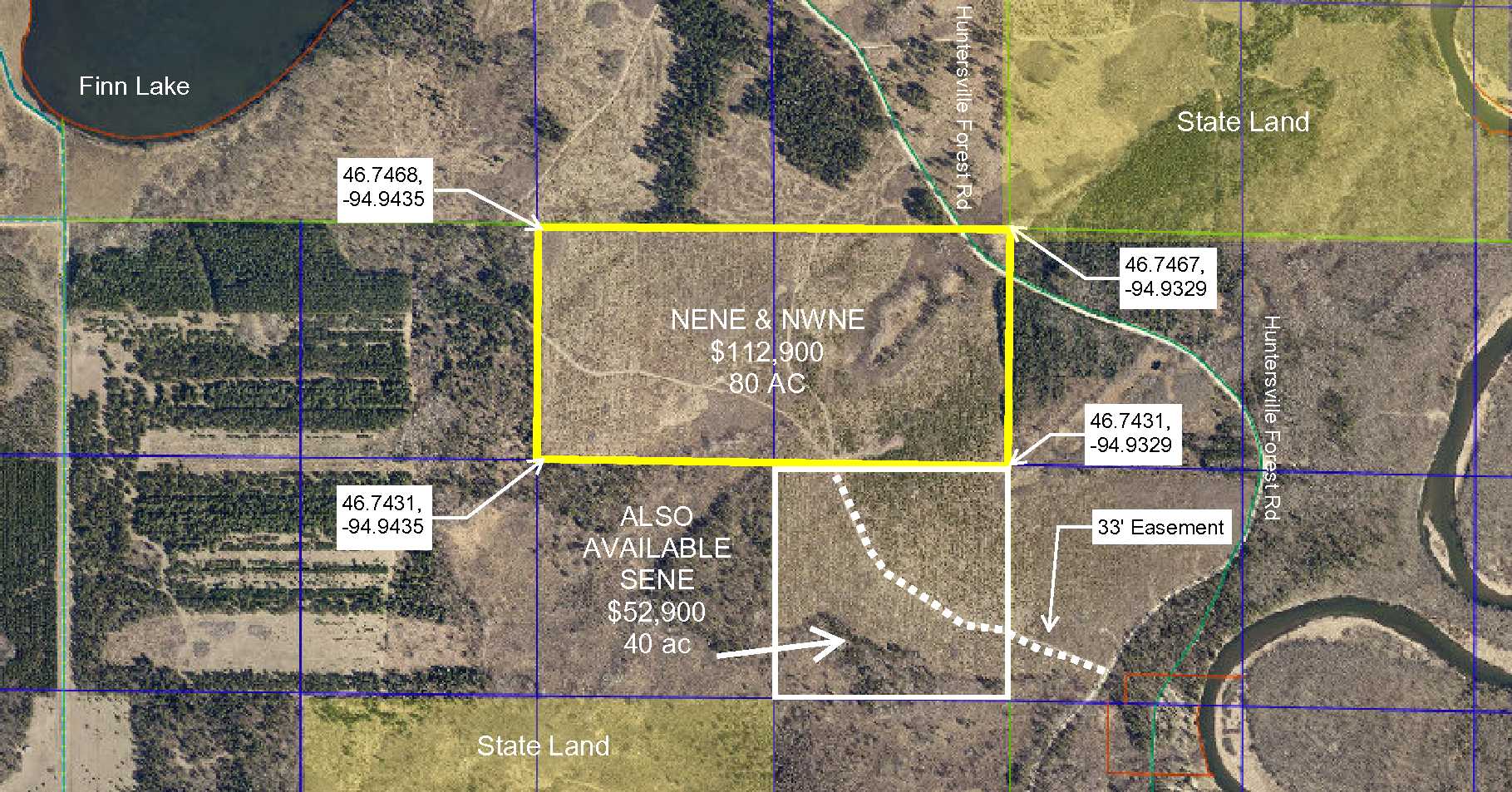
Get your hunting gear ready! This 80 acres has gently rolling terrain with younger red pine plantation and aspen growth. Close to the Crow Wing River, multiple lakes, restaurants, and shopping in Menahga and Park Rapids and Wadena Snowmobile Trail 214 runs through the property. Access to the parcel through easement as shown in the aerial photo or from Huntersville Forest Rd in the NE corner of the property (access but not insurable). Public access and campground on the Crow Wing River are nearby & the property adjoins the Huntersville State Forest. (NOTE: not a township maintained road to NE corner) Additional 40-acre parcel available to the south, MLS #4997771.
Main Property Info
Property ID
Pt R120261010
Pt R120261010
MLS Number
4997784
4997784
Status
Sold
Sold
List Price
$112,900
$112,900
Selling Price
$112,900
$112,900
Acres
80
80
Zoning
Agricultural A2
Agricultural A2
City
Menahga
Menahga
Township
Shell River Twp
Shell River Twp
State
MN
MN
Zip Code
56464
56464
County
Wadena
Wadena
Legal Description
NENE & NWNE, 26-138-34, together with a 33 ingress/egress easements over & across SENE to south line of subject property and together with a 33' easement from Huntersville Forest Rd over and across the SWSW 25-136-34, subject to any easements, reservations, and restrictions of record.
NENE & NWNE, 26-138-34, together with a 33 ingress/egress easements over & across SENE to south line of subject property and together with a 33' easement from Huntersville Forest Rd over and across the SWSW 25-136-34, subject to any easements, reservations, and restrictions of record.
Property Location
Directions
In Menahga from the intersection of Hwy 71 and Co Rd 31, go east 4 miles to Co Rd 23 (Hubbard Rd), turn south for 1.5 miles to 340th St, turn east for 4 miles to Huntersville Forest Rd, turn north (.2 miles before Mary Brown Bridge). Continue 1.5 miles to trail entrance on the west side of the road.
In Menahga from the intersection of Hwy 71 and Co Rd 31, go east 4 miles to Co Rd 23 (Hubbard Rd), turn south for 1.5 miles to 340th St, turn east for 4 miles to Huntersville Forest Rd, turn north (.2 miles before Mary Brown Bridge). Continue 1.5 miles to trail entrance on the west side of the road.
Access
Access to property on trail off of Huntersville Forest Rd. approximately .4 miles to the south line of the property. Huntersville Forest Rd also intersects the NE corner of the property. (NOTE: not a township maintained road from Casey's Landing Road)
Access to property on trail off of Huntersville Forest Rd. approximately .4 miles to the south line of the property. Huntersville Forest Rd also intersects the NE corner of the property. (NOTE: not a township maintained road from Casey's Landing Road)
GPS Coordinates
Coordinates to approximate corners/points based on county mapping: NE corner = 46.7467, -94.9329; SE corner = 46.7431, -94.9329; SW corner = 46.7431, -94.9435; NW corner = 46.7468, -94.9435.
Coordinates to approximate corners/points based on county mapping: NE corner = 46.7467, -94.9329; SE corner = 46.7431, -94.9329; SW corner = 46.7431, -94.9435; NW corner = 46.7468, -94.9435.
Address
TBD Huntersville Forest Rd
TBD Huntersville Forest Rd
School District
Menahga - 821
Menahga - 821
Property Details
Dimensions (approx)
2640 x 1320 x 2640 x 1320
2640 x 1320 x 2640 x 1320
Utilities
Power Company
Todd-Wadena Electric (1-800-320-8932)
Todd-Wadena Electric (1-800-320-8932)
Taxes & Fees
Tax Amount
$1,242
$1,242
Tax With Assessments
$1,242
$1,242
Tax Year
2020
2020
Other Details
Section Number
26
26
Township Number
138
138
Range Number
34
34
Estimated Upland %
96
96
Estimated Wetland %
4
4
Additional Comments
Timber Comments
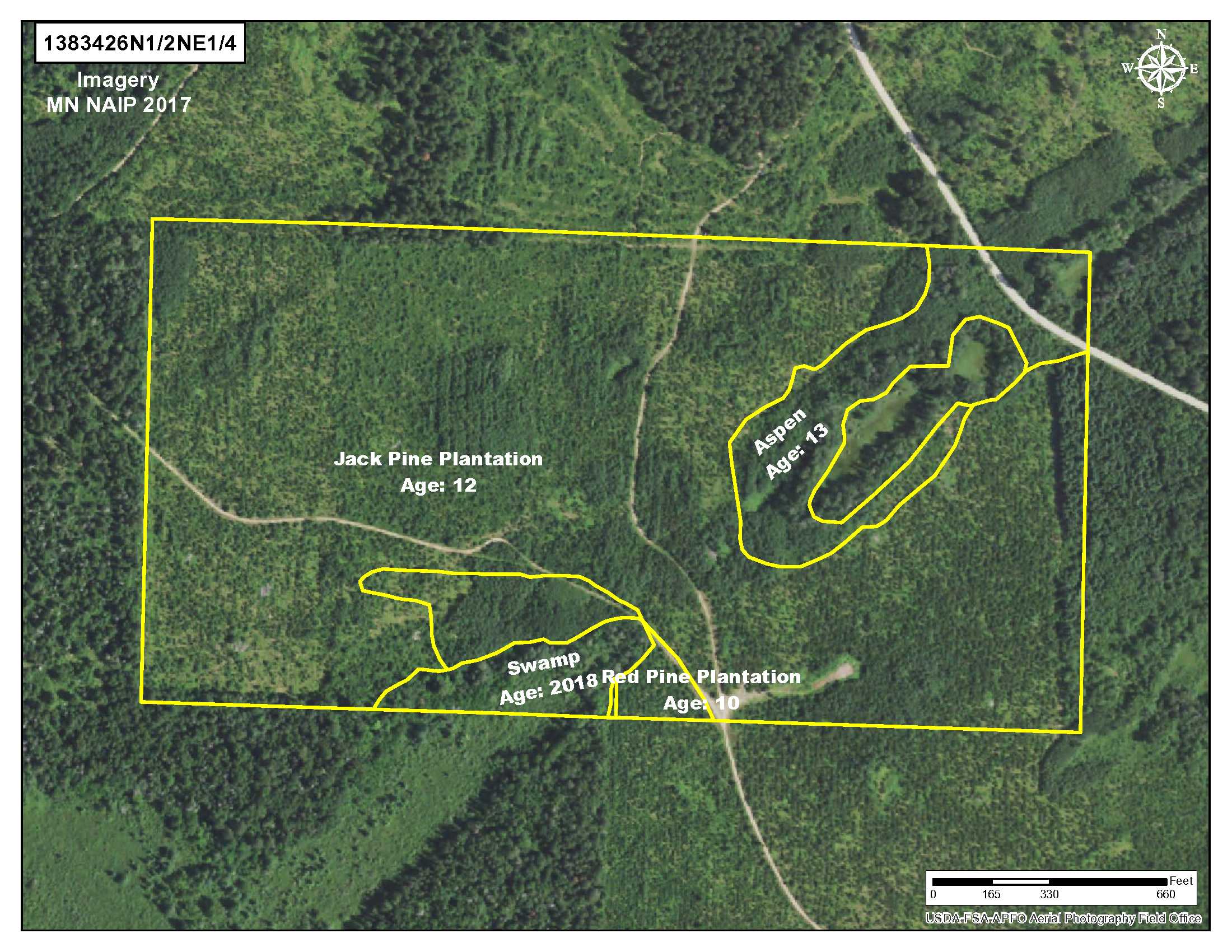
This property has been managed according to Forest Stewardship Council (FSC) standards. If timber value is important to you, seek the advice of a competent forester to determine species, volumes, and values. Jack Pine and Red Pine plantation and aspen on property.
This property has been managed according to Forest Stewardship Council (FSC) standards. If timber value is important to you, seek the advice of a competent forester to determine species, volumes, and values. Jack Pine and Red Pine plantation and aspen on property.
Hunting Comments
Located in MN Firearms Deer Zone 246.
Located in MN Firearms Deer Zone 246.
Disclosures
Together with an easement over and across SENE to south line of subject property and together with a 33' easement from Huntersville Forest Rd over and across the SWSW 25-136-34. Subject to snowmobile trails. Parcel split; acreage, dimensions, and taxes estimated based on county data and mapping; county disclaimers included by reference; subject to split approval if necessary. Not surveyed. Photos/maps for convenience only and not guaranteed; physically inspect prior to purchase. Any deer stands on the land are not property of seller and are not included in sale. Use seller-approved PA and addendum; closing dates the 3rd Wednesday each month. Huntersville Forest Road is not a township maintained road, but is a DNR prescriptive easement over the NE corner of this property.
Together with an easement over and across SENE to south line of subject property and together with a 33' easement from Huntersville Forest Rd over and across the SWSW 25-136-34. Subject to snowmobile trails. Parcel split; acreage, dimensions, and taxes estimated based on county data and mapping; county disclaimers included by reference; subject to split approval if necessary. Not surveyed. Photos/maps for convenience only and not guaranteed; physically inspect prior to purchase. Any deer stands on the land are not property of seller and are not included in sale. Use seller-approved PA and addendum; closing dates the 3rd Wednesday each month. Huntersville Forest Road is not a township maintained road, but is a DNR prescriptive easement over the NE corner of this property.


