
MLS Number : 4979194
Sold $34,900 - Hunting & Recreation, Premier & Development
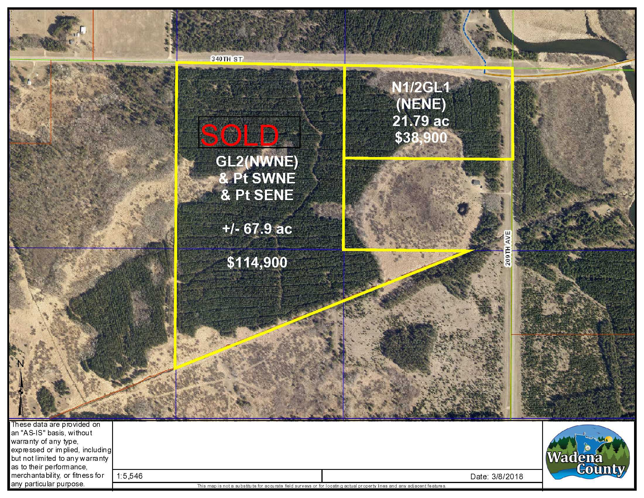
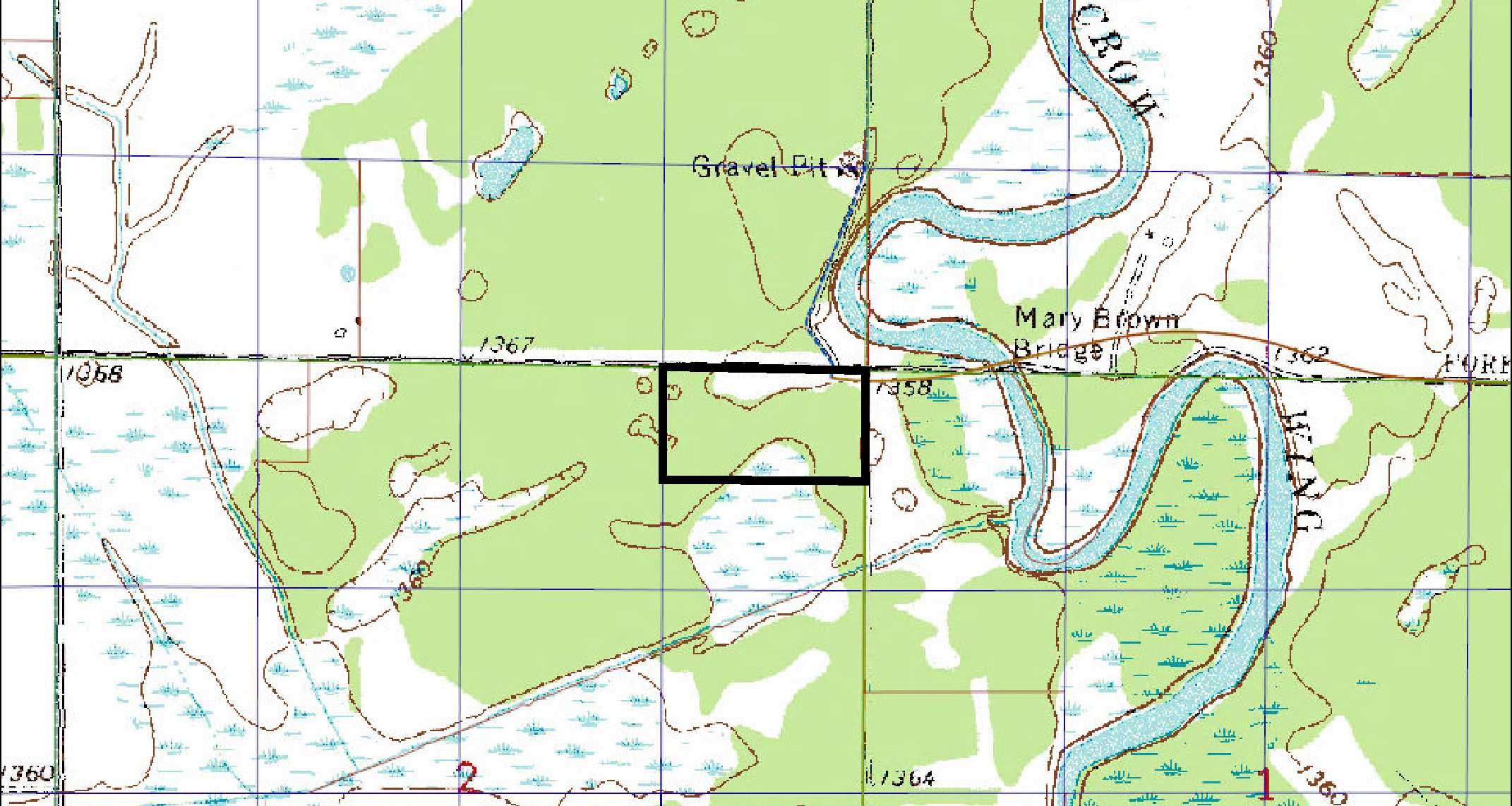
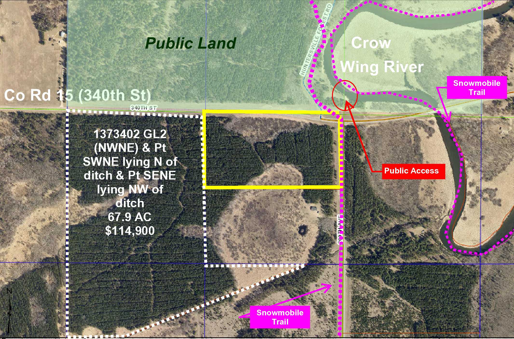
PotlatchDeltic land by the Crow Wing River east of Menagha and Sebeka. Located on the corner of Co Rd 15 (340th St) and Co Rd 14 (209th Ave) with access to the Crow Wing River and all it has to offer, from canoeing, kayaking, tubing, etc. A snowmobile trail runs along the property edge, part of Wadena Trail Breakers, Inc. and part of the MnUSA Corridor 69. With utilities within 1/4 mile, this site has building potential.
Main Property Info
Property ID
Pt 070021010
Pt 070021010
MLS Number
4979194
4979194
Status
Sold
Sold
List Price
$38,900
$38,900
Selling Price
$34,900
$34,900
Acres
21.79
21.79
Zoning
A2 Mixed Ag
A2 Mixed Ag
City
Menahga
Menahga
Township
Meadow Twp
Meadow Twp
State
MN
MN
Zip Code
56464
56464
County
Wadena
Wadena
Legal Description
N2GL1 (NENE) 02-137-34. Subject to Co Rd 15 (340th St) and 209th Ave, and any other easements, restrictions or reservations of record.
N2GL1 (NENE) 02-137-34. Subject to Co Rd 15 (340th St) and 209th Ave, and any other easements, restrictions or reservations of record.
Property Location
Directions
From the intersection of US Hwy 71 and Co Rd 13 north of Sebeka, east on Co Rd 13 for 4.4 miles. Left on Co Rd 23 (Hubbard Rd) 1.1 miles. Right on Co Rd 15 (340th St) 4 miles to property located on the right, directly before 209th Ave.
From the intersection of US Hwy 71 and Co Rd 13 north of Sebeka, east on Co Rd 13 for 4.4 miles. Left on Co Rd 23 (Hubbard Rd) 1.1 miles. Right on Co Rd 15 (340th St) 4 miles to property located on the right, directly before 209th Ave.
Access
Direct access to the property from the paved road Co Rd 15 (340th St) is along the north boundary and the paved road Co Rd 14 along the east boundary. Direct access from public roads, however, no approach has been constructed.
Direct access to the property from the paved road Co Rd 15 (340th St) is along the north boundary and the paved road Co Rd 14 along the east boundary. Direct access from public roads, however, no approach has been constructed.
GPS Coordinates
Coordinates to approximate corners/points based on county mapping: From northeast corner of property, 46.7176 - 94.9380 to northeast corner 46.7176 - 94.9328, to southeast corner 46.7156 - 94.9327 to southwest corner 46.7156 - 94.9327.
Coordinates to approximate corners/points based on county mapping: From northeast corner of property, 46.7176 - 94.9380 to northeast corner 46.7176 - 94.9328, to southeast corner 46.7156 - 94.9327 to southwest corner 46.7156 - 94.9327.
Address
Co Rd 15 (340th St)
Co Rd 15 (340th St)
School District
Menahga - 821
Menahga - 821
Property Details
Dimensions (approx)
1320 x 725 x 1320 x 725
1320 x 725 x 1320 x 725
Utilities
Available Utilities
Electric
Electric
Power Company
Todd-Wadena Electric (1-800-320-8932)
Todd-Wadena Electric (1-800-320-8932)
Taxes & Fees
Tax Amount
$357
$357
Assessment Amount
0
0
Tax Year
2018
2018
Other Details
Section Number
02
02
Township Number
137
137
Range Number
34
34
Estimated Upland %
70
70
Estimated Wetland %
30
30
Additional Comments
Timber Comments
This property has been managed according to Forest Stewardship Council (FSC) standards and is wooded with red pine plantation. If timber value is important to you, seek the advice of a competent forester to determine species, volumes, and values.
This property has been managed according to Forest Stewardship Council (FSC) standards and is wooded with red pine plantation. If timber value is important to you, seek the advice of a competent forester to determine species, volumes, and values.
Hunting Comments
Located in MN Firearms Deer Zone 246 with public land nearby to the north.
Located in MN Firearms Deer Zone 246 with public land nearby to the north.
Disclosures
Subject to snowmobile trail along east side. Parcel split; acreage, dimensions, and taxes estimated based on county data and mapping; county disclaimers included by reference; subject to split approval if necessary. Not surveyed. Photos/maps for convenience only and not guaranteed; physically inspect prior to purchase. Any deer stands on the land are not property of seller and are not included in sale. Use seller-approved PA and addendum; closing dates the 3rd Wednesday each month.
Subject to snowmobile trail along east side. Parcel split; acreage, dimensions, and taxes estimated based on county data and mapping; county disclaimers included by reference; subject to split approval if necessary. Not surveyed. Photos/maps for convenience only and not guaranteed; physically inspect prior to purchase. Any deer stands on the land are not property of seller and are not included in sale. Use seller-approved PA and addendum; closing dates the 3rd Wednesday each month.