
MLS Number : 4941355
Sold $113,500 - Hunting & Recreation, Waterfront Properties
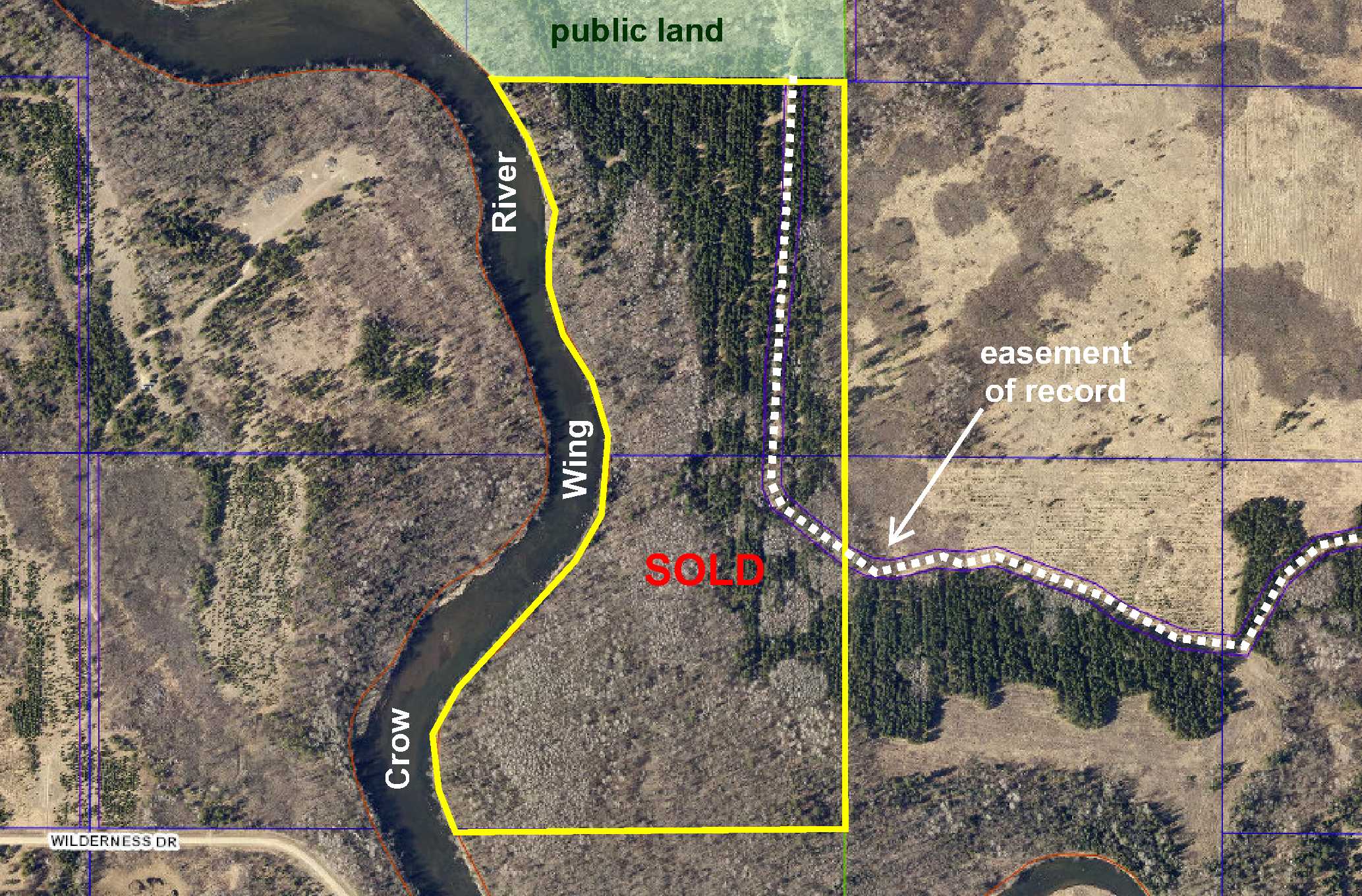
Secluded PotlatchDeltic land on the Crow Wing River southeast of Nimrod. Fairly level upland topography wooded with red pine, jack pine, and oak. Approx 2,970 ft of pristine river frontage. Access via gated easement trail from 271st Ave (Co Rd 140). The easement trail continues through portion of the property to provide access to public land adjoining the north. Excellent deer and waterfowl habitat for hunting. Snowmobile trail along the river offers great winter recreation too!
Main Property Info
Property ID
060151010 & 060154020
060151010 & 060154020
MLS Number
4941355
4941355
Status
Sold
Sold
List Price
$125,900
$125,900
Selling Price
$113,500
$113,500
Acres
68.05
68.05
Zoning
A-2 Mixed Agriculture & S-1 Shoreland Overlay
A-2 Mixed Agriculture & S-1 Shoreland Overlay
City
Verndale
Verndale
Township
Lyons Twp
Lyons Twp
State
MN
MN
Zip Code
56481
56481
County
Wadena
Wadena
Legal Description
GL3(SENE) & GL4(NESE), 15-136-33. Together with easements in Doc 216280 and Exhibits A-1, A-2, B-1, and B-2 (see Supplements); subject to easement in Doc 243221 and any other easements, restrictions, or reservations of record.
GL3(SENE) & GL4(NESE), 15-136-33. Together with easements in Doc 216280 and Exhibits A-1, A-2, B-1, and B-2 (see Supplements); subject to easement in Doc 243221 and any other easements, restrictions, or reservations of record.
Property Location
Directions
From the intersection of State Hwy 64 & Cass Co Rd 23 (60th St SW) north of Motley, west on Cass Co Rd 23 (60th St SW), which turns into Wadena Co Rd 7, for 5 miles. Right on Co Rd 140 (271st Ave) for 1.3 miles. Left (west, south, and west) on easement trail (gated) 1.8 miles into east side of the property.
From the intersection of State Hwy 64 & Cass Co Rd 23 (60th St SW) north of Motley, west on Cass Co Rd 23 (60th St SW), which turns into Wadena Co Rd 7, for 5 miles. Right on Co Rd 140 (271st Ave) for 1.3 miles. Left (west, south, and west) on easement trail (gated) 1.8 miles into east side of the property.
Access
The property is accessed via gated easement trail from 271st Ave (Co Rd 140).
The property is accessed via gated easement trail from 271st Ave (Co Rd 140).
GPS Coordinates
See map for coordinates to approximate corners/points based on county mapping.
See map for coordinates to approximate corners/points based on county mapping.
Address
271st Ave (Co Rd 140)
271st Ave (Co Rd 140)
School District
Sebeka - 820
Sebeka - 820
Property Details
Dimensions (approx)
2640 x 1368 x 2971 x 1233 IRR
2640 x 1368 x 2971 x 1233 IRR
Utilities
Power Company
Todd-Wadena Electric (1-800-320-8932)
Todd-Wadena Electric (1-800-320-8932)
Waterfront
Waterfront Name
Crow Wing River
Crow Wing River
Waterfront Feet (approx)
2970
2970
Taxes & Fees
Tax Amount
$1,716
$1,716
Tax With Assessments
$1,716
$1,716
Tax Year
2020
2020
Other Details
Section Number
15
15
Township Number
136
136
Range Number
33
33
Estimated Upland %
99
99
Estimated Wetland %
1
1
Additional Comments
Timber Comments
This property has been managed according to Forest Stewardship Council (FSC) standards and is wooded with red pine, jack, pine, and oak. If timber value is important to you, seek the advice of a competent forester to determine species, volumes, and values.
This property has been managed according to Forest Stewardship Council (FSC) standards and is wooded with red pine, jack, pine, and oak. If timber value is important to you, seek the advice of a competent forester to determine species, volumes, and values.
Hunting Comments
This property adjoins public land in MN Firearms Deer Zone 246.
This property adjoins public land in MN Firearms Deer Zone 246.
Disclosures
Easement trail is gated; contact listing agent for information on viewing. Portions along the river fall within the FEMA flood zone. Not surveyed; acreage and dimensions approximate based on county data and mapping; county disclaimers included by reference. Photos/maps for convenience only and not guaranteed; physically inspect prior to purchase. Any deer stands on the land are not property of seller and are not included in sale. Use seller-approved PA and addendum; closing dates the 3rd Wednesday each month.
Easement trail is gated; contact listing agent for information on viewing. Portions along the river fall within the FEMA flood zone. Not surveyed; acreage and dimensions approximate based on county data and mapping; county disclaimers included by reference. Photos/maps for convenience only and not guaranteed; physically inspect prior to purchase. Any deer stands on the land are not property of seller and are not included in sale. Use seller-approved PA and addendum; closing dates the 3rd Wednesday each month.


