


MLS Number : 4832052
Sold $103,300 - Hunting & Recreation
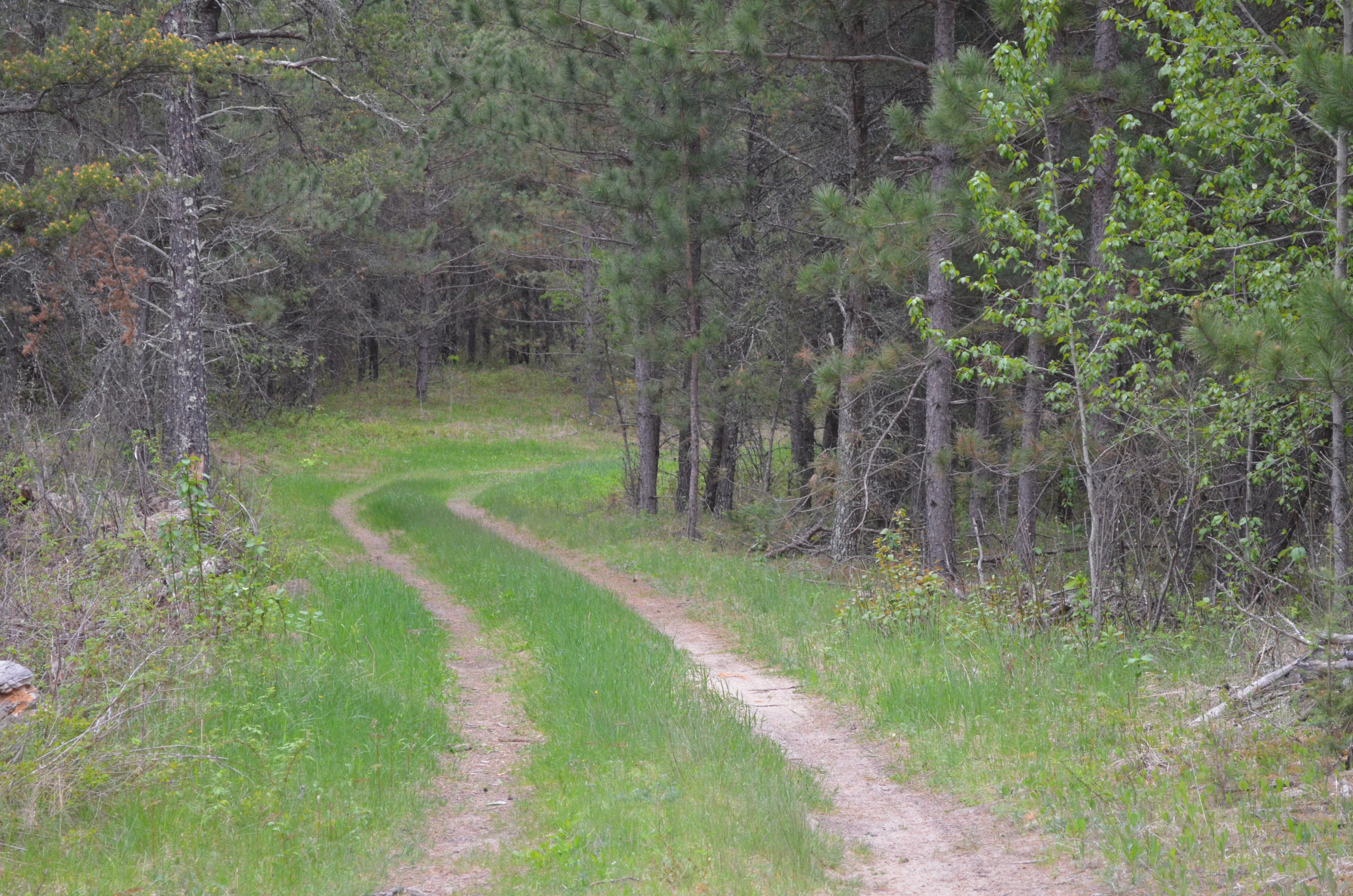
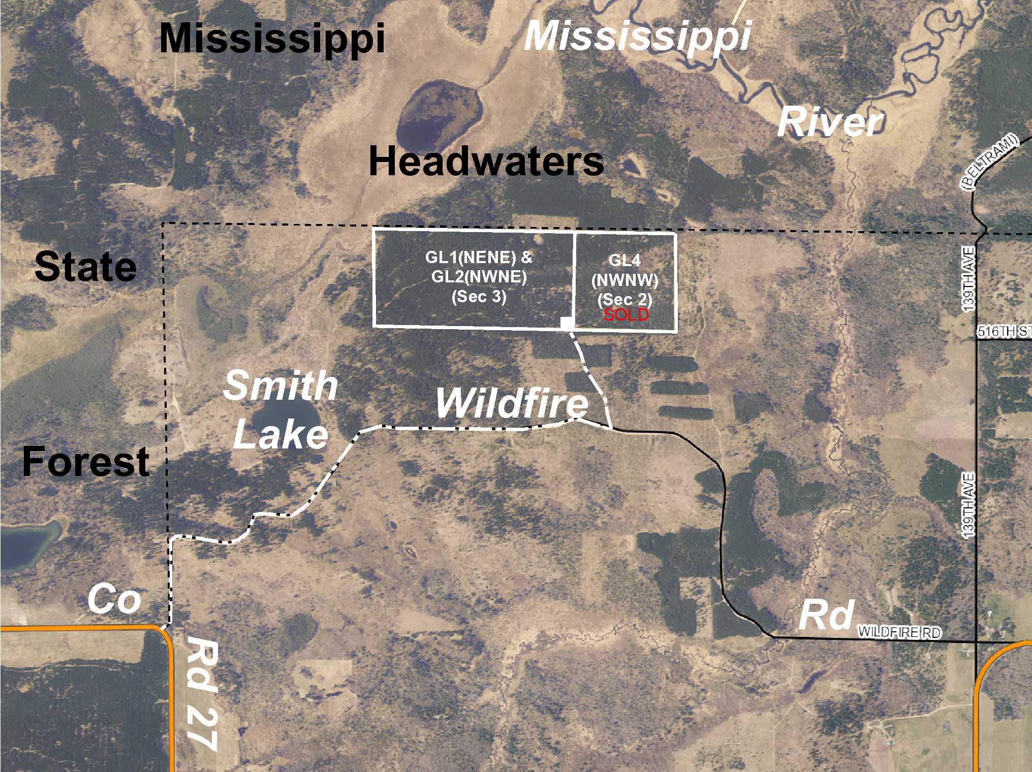
Potlatch land by the Mississippi River south of Solway. Level to sloping upland wooded with varying ages of red pine. Public land adjoins three sides, including public Mississippi Headwaters State Forest land to the north. Access is via an easement trail from Wildfire Rd. Fantastic opportunity to secure some accessible-but-remote hunting land for years of enjoyment.
Main Property Info
Property ID
080300100 & 080300200
080300100 & 080300200
MLS Number
4832052
4832052
Status
Sold
Sold
List Price
$112,900
$112,900
Selling Price
$103,300
$103,300
Acres
76.52
76.52
Zoning
not zoned
not zoned
City
Solway
Solway
Township
Fern Twp
Fern Twp
State
MN
MN
Zip Code
56678
56678
County
Hubbard
Hubbard
Legal Description
GL1(NENE) & GL2(NWNE), 03-145-35. Together with easement described in Doc# A000388361. Subject to easement over the south 50 ft of the east 50 ft of GL1(NENE) and any other easements, restrictions, or reservations of record.
GL1(NENE) & GL2(NWNE), 03-145-35. Together with easement described in Doc# A000388361. Subject to easement over the south 50 ft of the east 50 ft of GL1(NENE) and any other easements, restrictions, or reservations of record.
Property Location
Directions
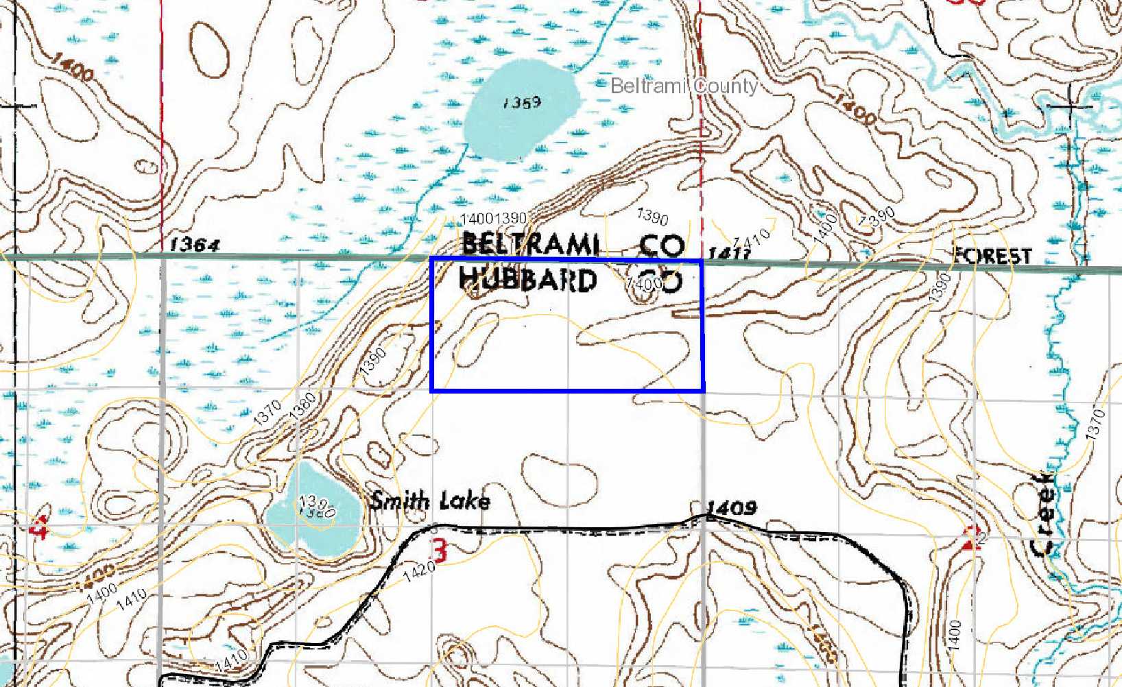
From the intersection of US Hwy 2 and Beltrami Co Rd 5 (Centerline Rd N) in Solway, south on Beltrami Co Rd 5 (Centerline Rd N) (which turns into Hubbard Co Rd 27) for 8 9/10 miles. Left on Wildfire Rd 1 1/2 miles. Left on easement trail for 2/10 mile into southeast corner of the property.
From the intersection of US Hwy 2 and Beltrami Co Rd 5 (Centerline Rd N) in Solway, south on Beltrami Co Rd 5 (Centerline Rd N) (which turns into Hubbard Co Rd 27) for 8 9/10 miles. Left on Wildfire Rd 1 1/2 miles. Left on easement trail for 2/10 mile into southeast corner of the property.
Access
Access is via an easement trail off Wildfire Rd.
Access is via an easement trail off Wildfire Rd.
GPS Coordinates
Coordinates to approximate corners/points based on flagged points: SE corner (near where easement trail enters) = 47.4088, -95.0980; SW corner = 47.4089, -95.1086; NW corner = 47.4124, -95.1086; NE corner = 47.4123, -95.0979.
Coordinates to approximate corners/points based on flagged points: SE corner (near where easement trail enters) = 47.4088, -95.0980; SW corner = 47.4089, -95.1086; NW corner = 47.4124, -95.1086; NE corner = 47.4123, -95.0979.
Address
Wildfire Rd
Wildfire Rd
School District
Bemidji - 31
Bemidji - 31
Property Details
Dimensions (approx)
2640 x 1270 x 2640 x 1270
2640 x 1270 x 2640 x 1270
Utilities
Power Company
Beltrami Electric (1-800-955-6083)
Beltrami Electric (1-800-955-6083)
Taxes & Fees
Tax Amount
$882
$882
Tax Year
2018
2018
Other Details
Section Number
03
03
Township Number
145
145
Range Number
35
35
Estimated Upland %
99
99
Estimated Wetland %
1
1
Additional Comments
Timber Comments
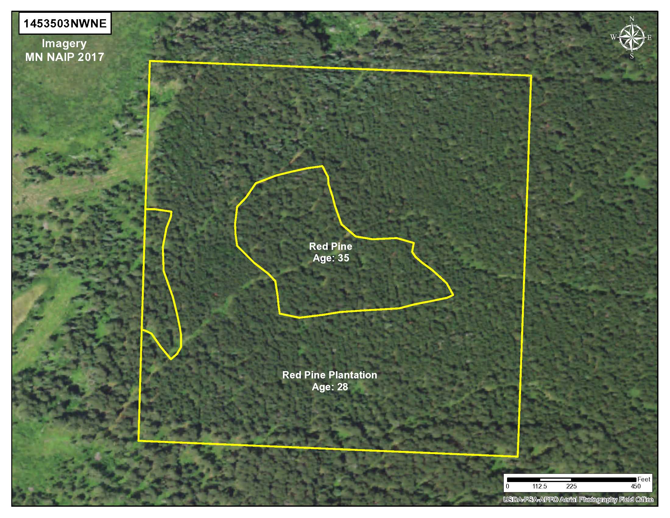
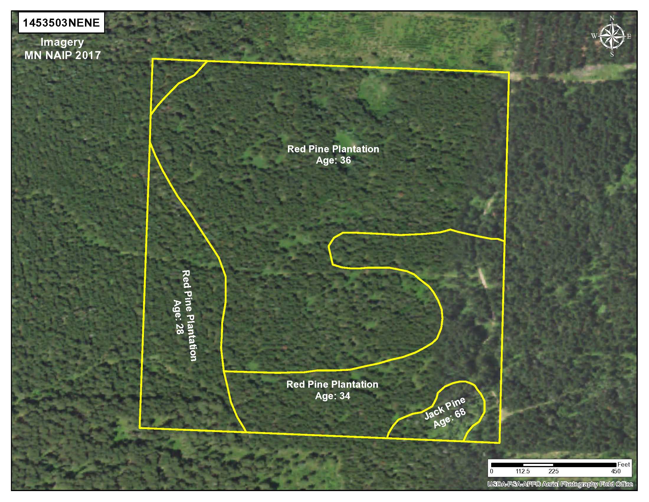
This property has been managed according to Forest Stewardship Council (FSC) standards and is wooded with varying ages of red pine. If timber value is important to you, seek the advice of a competent forester to determine species, volumes and values.
This property has been managed according to Forest Stewardship Council (FSC) standards and is wooded with varying ages of red pine. If timber value is important to you, seek the advice of a competent forester to determine species, volumes and values.
Hunting Comments
This property adjoins public land in MN Firearms Deer Zone 184.
This property adjoins public land in MN Firearms Deer Zone 184.
Disclosures
Not surveyed; acreage and dimensions approximate based on county data and mapping; county disclaimers included by reference. Photos/maps for convenience only and not guaranteed; physically inspect prior to purchase. Any deer stands on the land are not property of seller and are not included in sale. Use seller-approved PA and addendum; closing dates the 3rd Wednesday each month.
Not surveyed; acreage and dimensions approximate based on county data and mapping; county disclaimers included by reference. Photos/maps for convenience only and not guaranteed; physically inspect prior to purchase. Any deer stands on the land are not property of seller and are not included in sale. Use seller-approved PA and addendum; closing dates the 3rd Wednesday each month.


